Los Angeles
Routes
Los Angeles offers an exceptionally varied landscape for running, with routes that span mountains, canyons, beaches, lakes, and grand urban boulevards. In the heart of the city, runners gravitate toward Griffith Park, a vast oasis with everything from gentle fire roads to challenging climbs, while nearby Runyon Canyon and the Santa Monica Mountains provide even more rugged trail options with panoramic views. Closer to the neighborhoods, Echo Park and the Silver Lake Reservoir offer relaxed, scenic loops perfect for everyday miles. For breezier, flatter running, the oceanfront paths through Santa Monica, Venice, and into Marina del Rey deliver wide, continuous stretches ideal for long, scenic efforts. LA’s iconic boulevards, including Sunset, Hollywood, Santa Monica, Wilshire, and Exposition, also create long, connective routes through vibrant corridors of the city. Beyond the core, LA County adds still more variety, from foothill trails around Pasadena and Altadena to coastal paths along the ocean, giving runners a rich range of terrain without traveling far.

Culture
Los Angeles has one of the most diverse and visually stunning running scenes in the country, anchored by a vibrant, community-driven culture. The city’s run club scene is especially lively and neighborhood-focused, with groups like Koreatown Run Club, Good Vibes Track Club, and Silver Lake Track Club creating welcoming spaces that blend fitness, friendship, and LA’s creative energy. New running stores such as LSD Running in Echo Park and Heartbreak Hill Running Company in Santa Monica have become community hubs for group runs and local events. Capping it all off is the Los Angeles Marathon, one of the largest in the nation, alongside countless local races throughout LA and Orange County that showcase the region’s year-round perfect running weather and passionate running culture.
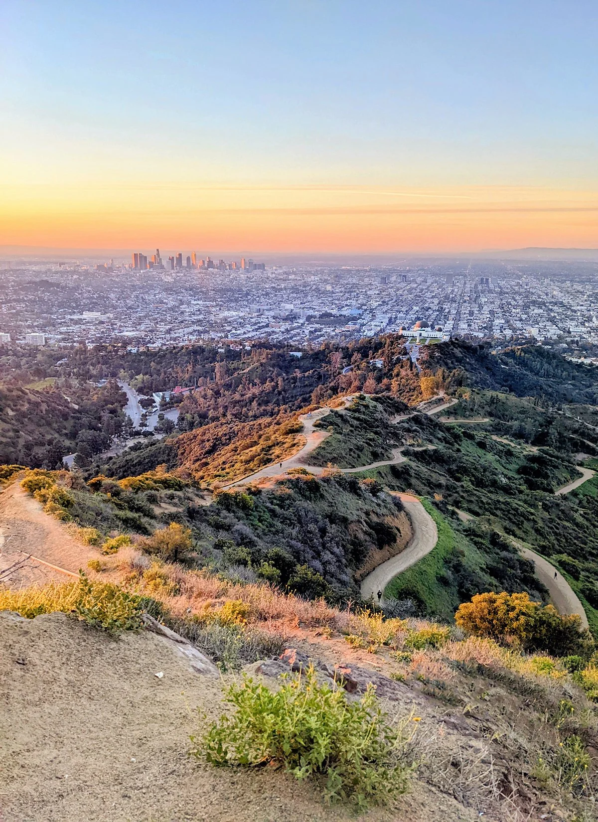
1. Griffith Park
• Start & Finish: Greek Theater
• Course Profile: 5.1 miles, 1040 ft+, mostly trail (Strava in bio)
Griffith Park is one of the country's largest city parks with urban wilderness. A sunrise trail run in Griffith, featuring breathtaking panoramic views at Griffith Observatory and/or Mt. Hollywood Summit is an unforgettable LA experience. This route is a loop starting and ending at the Greek Theater. It follows (counter clockwise) Riverside Trail, Hogback Trail, Mt Hollywood Trail, and Boy Scout Trail. Griffith Park has a myriad of trails so other options are abundant. In particular, if you want to enjoy nature without climbing hills, Main Trail is a long, flat trail along the LA river on the east periphery of the park.
Along this 5-mile route, there are two particular places to visit.
- Griffith Observatory: The Los Angeles landmark sits on a hill overlooking Downtown LA and Hollywood, and offers free-admission to scientific exhibits inside the observatory, as well as a telescope.
- Mt. Hollywood Summit: This is the hill straight above the observatory (not the hill that the Hollywood sign sits on, which js actually Mt. Lee) and offers an even grander, sweeping view.
- To "visit" Hollywood Sign, take the single track Mt. Chapel Trail off Mt. Hollywood Dr. It leads to Mt. Lee Dr, which goes above the iconic sign. This will make a 3.7-mile out and back detour from Mt. Hollwyood Summit with additional 800 ft+.
Also check out Dante's View and Amir's Garden.
The route connects with
- Silver Lake - Echo Park (Route #5)
- Hollywood Blvd (Route #7)
- LA River Trail (Route #14)
Run Clubs / @blacklistla usually has their Saturday long run in the park, and sometimes does @silverlaketrackclub too.
Cafe / Maru Coffee and Friends & Family are among my favorite coffee shops and bakeries in the city. Many other cafes are located on Hillhurst Ave, Vermont Ave, and Hollywood Blvd.
Transit / Hollywood/Western in on Metro Line A (Red). Metro Bus 96, 180, 182 serve the Los Feliz neighborhood.

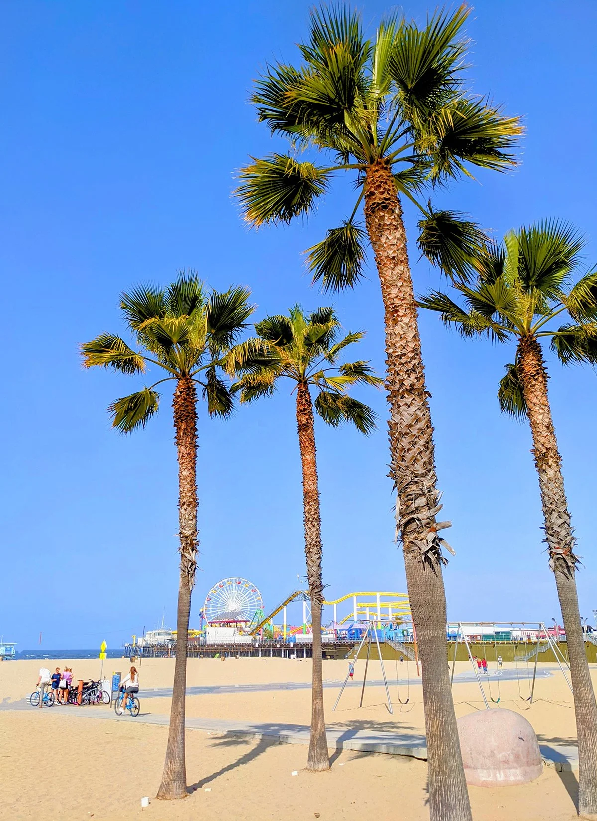
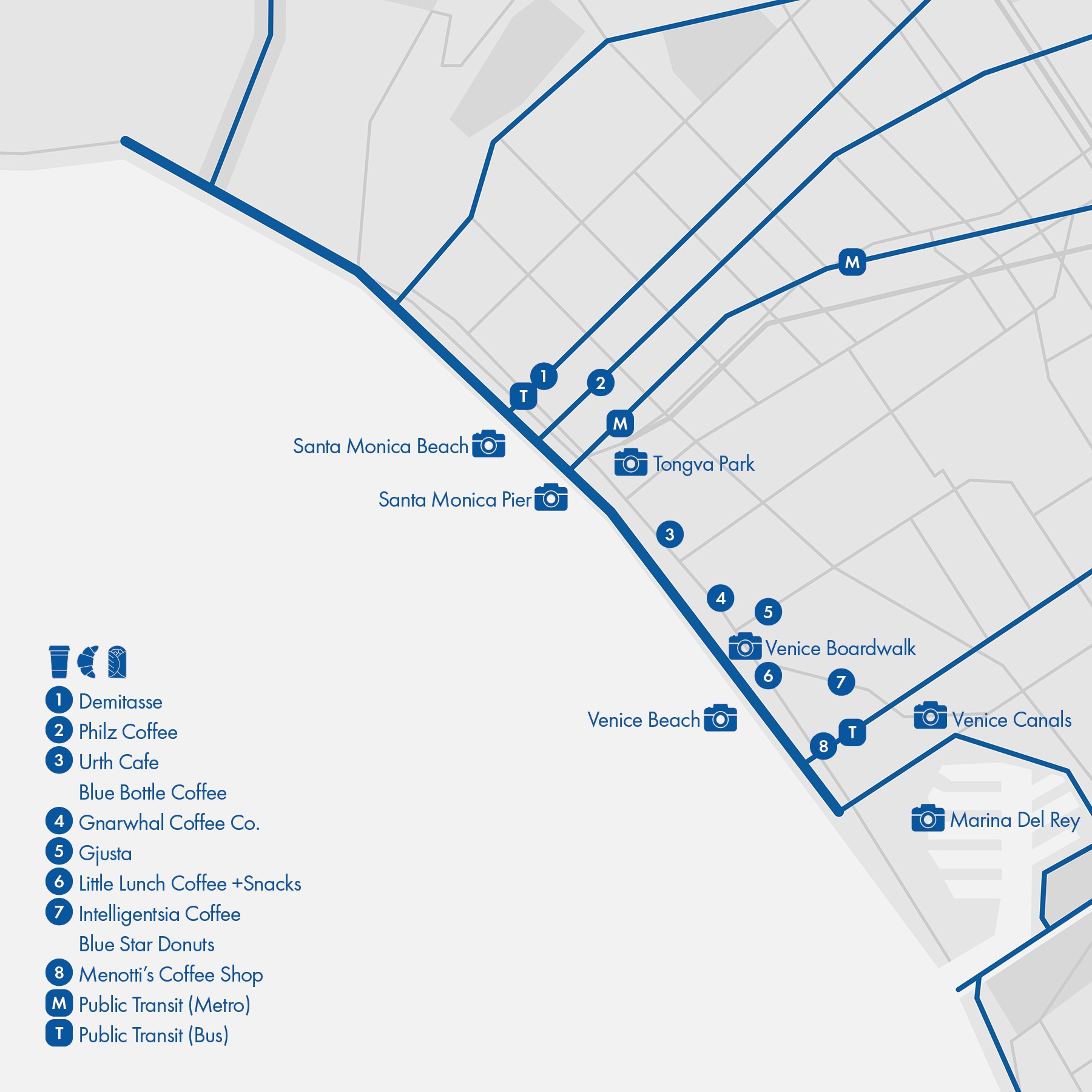
2. Ocean Front
• Start & Finish: Will Rogers Beach (Pacific Palisades), Venice Beach
• Course Profile: 6.4 miles, flat; multi-use path (Strava in bio)
This trail connecting Santa Monica and Venice is a true fitness hub, it is heavily used by walkers, runners, cyclists, rollerblade rollers, surfers...The trail goes as north as Temescal Canyon Rd and runs on the beach southward till Washington Blvd in Venice. It's easy to follow, just watch out for trail traffic and intersections.
Things to see and visit:
- Beaches: It's oceanfront, what else do you expect? Check out the original muscle beach in Santa Monica and skate park in Venice.
- Santa Monica Pier: The iconic pier marks the west end of US Route 66 and has a small amusement park that can be see from far away.
- Tongva Park: named after the indigenous Tongva people, the small downtown park has an oceanview overlook.
- Venice Boardwalk: known for funky souvenir shops and street artists, it is ususlly packed with tourists.
- Venice Canals: the Venice inspired canals are calm and surrounded by colorful houses, with narrow walk paths.
The route connects with many running routes that end by the ocean:
- Santa Monica Mountains Trails (Route #13)
- San Vicente / Santa Monica / Wilshire / Venice / Exposition Blvd (Route #18/#7/#8/#9/#10)
- Ballona Creek Trail (Route #19)
- Beach Cities "The Strand" (Route #20)
Run Clubs / many run clubs are based in this area, including
@venicerunclub @larebels @trackclubla with different run options. The lastest addition is a social run by @luftlosangeles called Junk Miles
Cafe / Santa Monica and Venice are two of the most touristy destinations in LA so you'll have no problem finding cafes, especially around 3rd Street Promenade (P10) in Santa Monica, along Main St in Ocean Park, and on Abbot Kinney Blvd in Venice.
Transit / Metro Line E (Expo) connects Downtown Santa Monica, Downtown Culver City and Downtown LA. The ocean front area is served by various lines of LA Metro Bus, Santa Monica Big Blue Bus, as well as Culver CityBus.
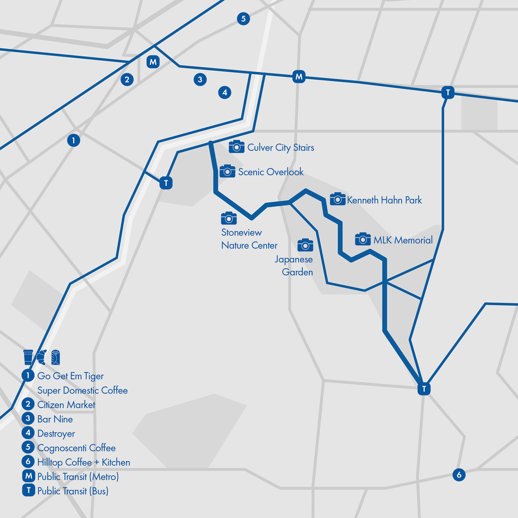
3. Baldwin Hills

• Start & Finish: Baldwin Hills Scenic Overlook trailhead
• Course Profile: 7 miles out and back, 1225 ft+; mostly trails, steep stairs optional (Strava link in bio)
South of Hollywood Hills, LA is one gigantic urban sprawl. Baldwin Hills is home to the only sizable mountains in this flatland. This route starts at the foot of Culver City Stairs, it continues to Kenneth Hahn park via Park to Playa Bridge and loops around in the big park before returning to the start. Besides the two official pedestrian entry points to Kenneth Hahn Park, there is a trail between the northeast part of the park and La Brea Ave (at Veronica St).
Things to see and visit
- Culver City Stairs & Scenic Overlook: The formidable stairs consist of 282 big, irregular steps, averaging 10 inches each. A switchback trail is the alternative option to go up to the hilltop overlook and trails.
- Stoneview Nature Center: a small nature center near Park to Playa Bridge, with weekend programs.
- Kenneth Hahn Park: the big state park features several miles of mountain trails, a small lake, a Japanese Garden, a Hummingbird Garden, and Martin Luther King, Jr. Memorial (P6). The views around Autumn's Peak are great.
This route is part of the Park to Playa Trail. The trail continues east of Kenneth Hahn Park along Stocker St (P9). Additional routes:
- Continue to Venice / Exposition Blvd (Route #9/#10)
- Continue to Ballona Creek Trail (Route #19)
Run Clubs /
@goodvibes_tc is a large run club based in nearby Rancho Cienega Rec Center
@movementrunners and @angelcityrunclub have weekly runs in Culver City
@thebreakfastrunclub runs from Norman O. Houston Park
Cafe / Downtown Culver City, packed with coffee shops and cafes, is several blocks away from Culver City Stairs. My favorites, however, are Destroyer and Bar Nine in the industrial area just east of downtown.
Transit / Metro Line E (Expo) stops at La Cienega Blvd and Downtown Culver City; the area is served by LA Metro Bus 33, 35, 37, 38, 105, 217, as well as Culver City Bus CC1 and CC4.
4. Elysian Park

• Start & Finish: Sunset Blvd at Lilac Pl (Strava in bio)
• Course Profile: 6.2 miles loop, 575 ft+; streets and trails
Elysian Park is a large, hilly city park just north of Downtown LA, site of Dodger Stadium. This route follows the main roads in the park and loops back to the start point from outside the park. Trail detours and shortcuts can be taken at different intersections.
Things to see and visit
- Angels Point: An overlook point on a small hill, where a post-modern metal sculpture of local artist Peter Shire is installed.
- Point Grand View: The name says it all. Follow the palm tree lined Grand View Dr for the sweeping view at this hidden gem viewpoint in Elysian Park.
- Dodger Stadium: The least urbanism-friendly ballpark, and the worst place to start a big city marathon. Still, it's Dodger Stadium.
- LA State Historic Park: A massive urban park with open green space and walking trails.
- Everett Park: The small hillside park looks out directly to Downtown LA.
- Chinatown: Though not as impressive as Chinatown of SF or NYC, Chinatown Central Plaza is still worth a quick visit.
Additional and alternative routes:
On the west, take Elysian Park Trail (cover, P3) instead of Elysian Park Dr. This dirt trail detour has great views and will add 1.2 miles/170 ft+.
On the north, take Frogtown Trail (P4) instead of Angels Point Rd. This single track trail has more challenging terrains, cliff views, but it is 0.4 mile shorter and 100 ft+ less.
On the east, take Grand View Dr instead of Park View Dr. This detour leads to Point Grand View (see below) and will add 0.7 mile/70 ft+.
- Continue to Silver Lake or Echo Park (Route #5)
- Continue to Downtown LA (Route #6)
- Continue to LA river Trail (Route #14) via bike path along Arroyo Seco Pkwy.
Cafe / Both Echo Park and Chinatown have great food scenes. In particular, visit Hill St and Broadway for traditional Cantonese dim sum for breakfast.
Transit / Chinatown is served by Metro Line L (Gold) and Bus 45, 81, 90, 94, 96. Sunset Blvd is served by Metro Bus 4.

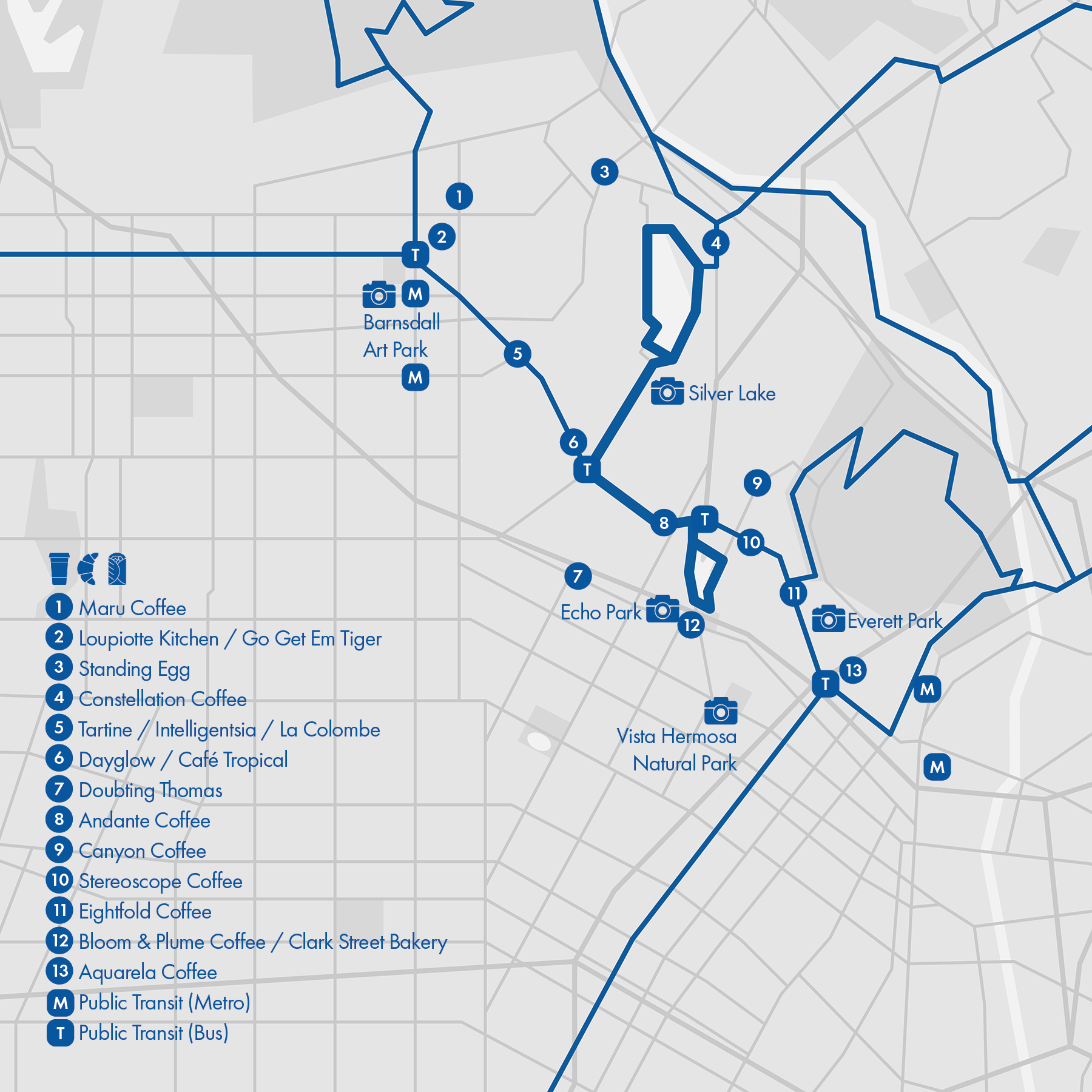
5. Silver Lake - Echo Park

• Start & Finish: Silver Lake Reservoir and Echo Park (Strava in bio)
• Course Profile: 5 miles, 200 ft+; sidewalks
Silverlake and Echo Park are my favorite neighborhoods in LA. The area has countless cafes and shops on the 3-mile stretch of Sunset Blvd, which is on @lamarathon route (P9). Silverlake Reservoir and Echo Park are two popular running spots and both have a loop trail. This route connects them through Sunset Blvd.
Things to see and visit
- Barnsdall Art Park: a hilltop park with The Hollyhock House designed by architect Frank Lloyd Wright. You'll get a good view of Griffith Observatory from here.
- Silver Lake: the hilly, residential neighborhood features a reservoir with a running trail, rolling hills with mural stairs (e.g. "Je t'aime LA" mural), and some of the best coffee shops in town.
- Echo Park: this beautiful park surrounding Echo Park Lake has a big water fountain, a boathouse and a one-mile running loop.
- Everett Park: Quite a hidden gem off Sunset Blvd. The small hillside park looks out directly to Downtown LA.
- Vista Hermosa Natural Park: an urban natural park with a walking trail, picnic areas, and a great view of the LA skyline.
Additional and alternative routes:
- Continue to Griffith Park (Route #1)
- Continue to Elysian Park (Route #4)
- Continue to Downtown LA (Route #6)
- Continue to Hollywood/Santa Monica Blvd (Route #7)
- Continue to LA River Trail (Route #14)
Run Club / @silverlaketrackclub is based in Silver Lake and does Tuesday easy runs on Sunset Blvd, Thursday workouts near Chinatown and Sunday long runs with varying routes.
Cafe / Stereoscope Coffee is my favorite coffee shop in LA. Popular coffee spots also include Maru Coffee, Dayglow, Canyon Coffee... For pastries and breakfast, I enjoyed Cafe Tropical, Doubting Thomas, and Clark Street Echo Park.
Transit / Metro stations at Sunset & Vermont and Union Station are on Line B (Red). Sunset Blvd is served by Metro Bus 4, with Bus 2, 10/48, 92, and 603 also serving this area.
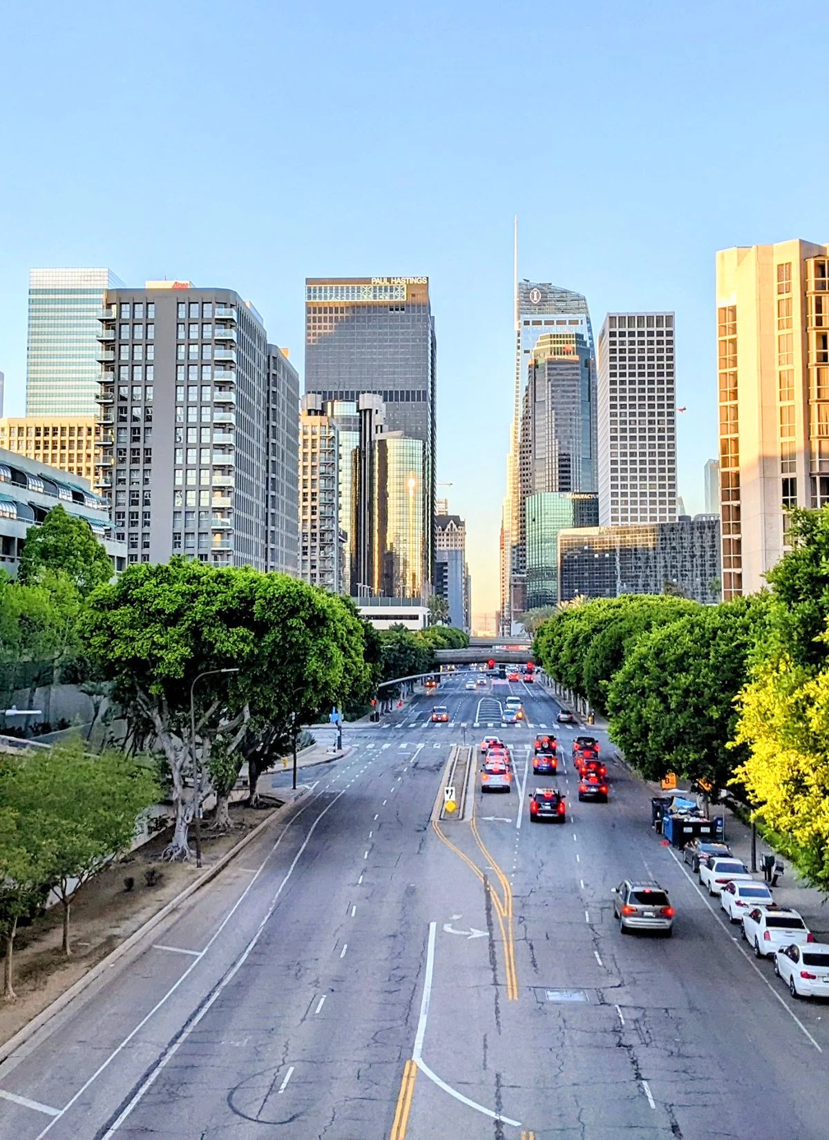
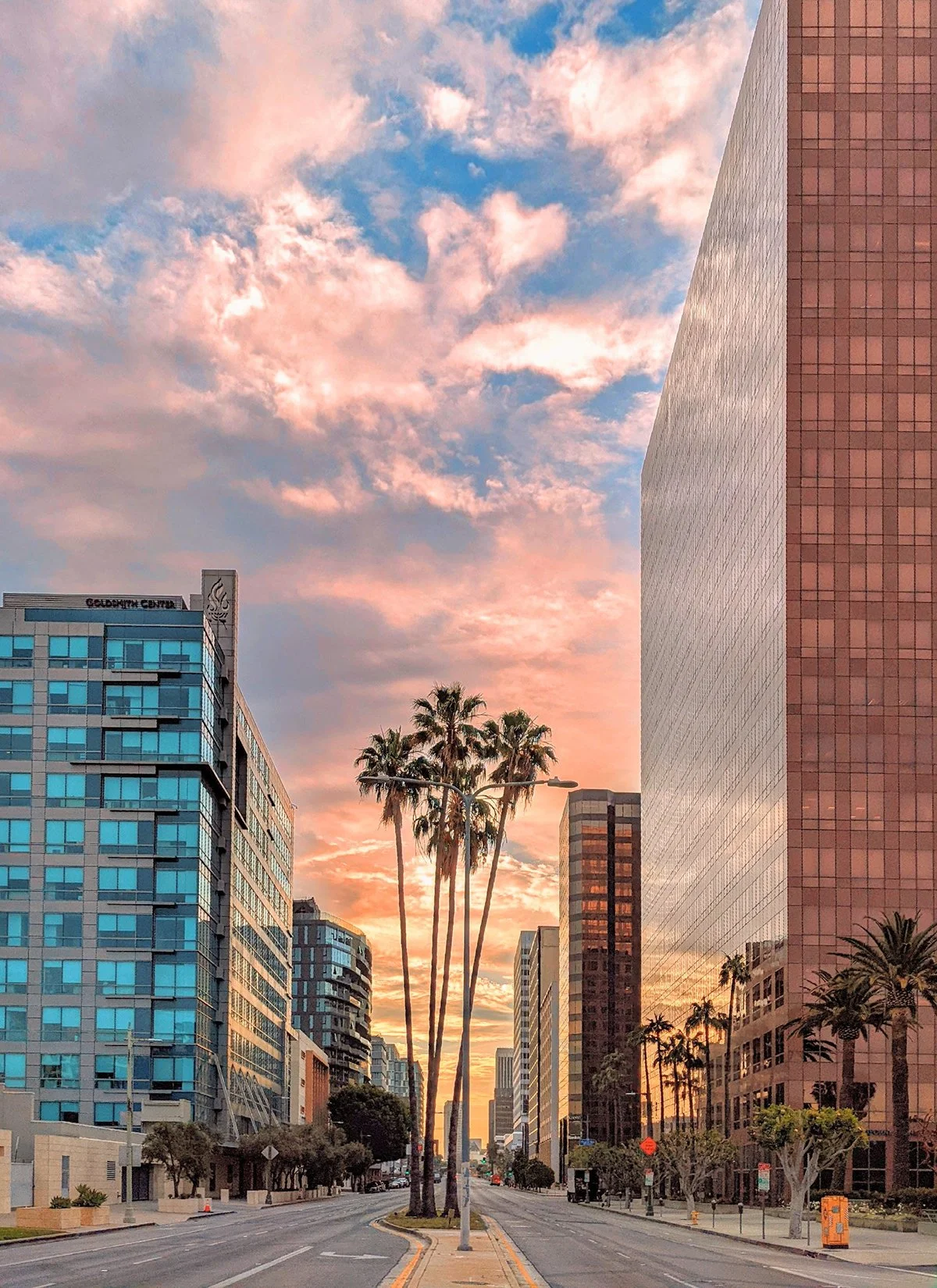
6. Downtown LA
• Start & Finish: Grand Ave (Strava in bio)
• Course Profile: 3-4 miles, 100-200 ft+; sidewalks
Downtown LA is remarkably diverse and vibrant. A short run can take one from Chinatown to Little Tokyo, from art museums to sports stadiums. Though Grand Ave is my favorite, explore as you wish. You may want to stay away from Skid Row, where there is a large homeless population.
Things to see and visit
- Union Station: largest railroad passenger terminal in the West, with a Mission Revival style tower and grand interior.
- Grand Park: big, long urban park that stretches over four city blocks, with LA City Hall on the east end.
- Walt Disney Concert Hall: home of the La Phil, the stunning structure is designed by world-renowned architect Frank Gehry.
- The Broad: art museum with artworks by the most well known contemporary artists. The building itself is also quite a piece of art.
- Arts District: a walkable neighborhood with murals, art studios, boutiques and cafes scattered all over it's short, narrow streets.
- 6th St Bridge: the brand new bridge (replacing a viaduct) features wide bike/ped access on both directions.
Additional and alternative routes:
- Take 1st St to Arts District. You can do a loop through Hollenbeck Park and 6th St.
- Take Figueroa St to Exposition Park
- Continue to Elysian Park (Route #4)
- Continue to Silver Lake - Echo Park (Route #5)
- Continue to Wilshire/Venice/Exposition Blvd (Route #8, 9, 10)
Run Clubs / several run clubs are active in DTLA
@angelcityrunclub @dtlarunning @blacklistla all have weekly group runs from here.
Cafe / It's downtown, so there are coffee shops and cafes everywhere. In particular, check out Grand Central Market and Arts District (along San Mateo and Santa Fe, including Maru Coffee, P10)
Transit / Union Station is the terminus for Metro B, D, L lines, LAX flyaway bus, and MetroLink services to cities and counties around LA. 7th St Metro Station is the transfer point for Metro A, B, D, E line. Downtown area is also heavily served by Metro buses.

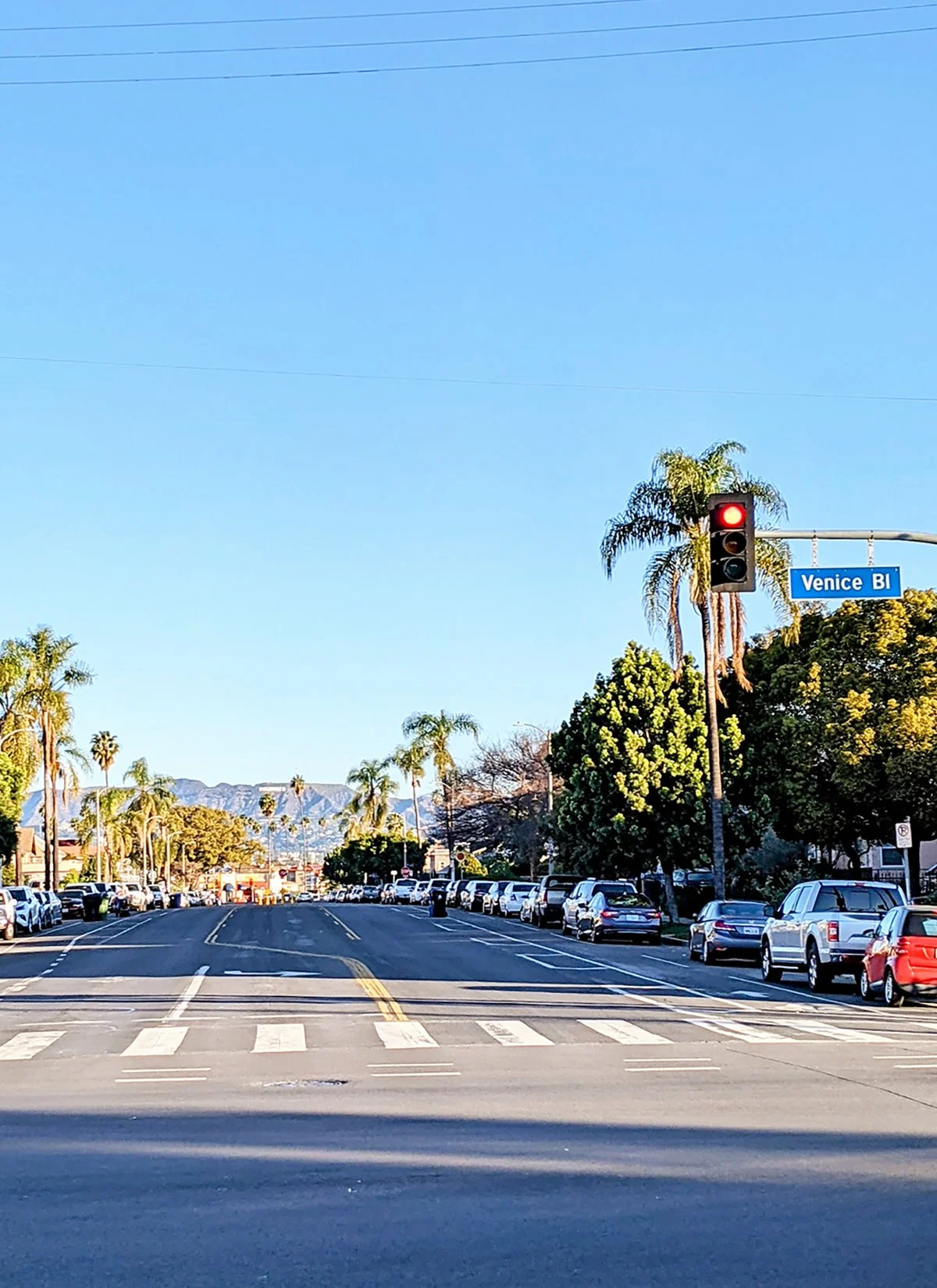
7. Hollywood & Santa Monica Boulevard

• Start & Finish: Hollywood at Vermont; Santa Monica at Ocean (Strava in bio)
• Course Profile: 14.8 miles, 228 ft+; sidewalks
This route along Hollywood Blvd and Santa Monica Blvd largely overlaps with @lamarathon course, and showcases some of the most iconic landmarks of LA. The essential segment is between Hollywood and Century City, after which the course continues downhill to the beach. LA marathon's new course doesn't finish in Santa Monica anymore, so why don't you do it yourself?
Things to see and visit
- Beverly Gardens Park: urban park that features Beverly Hills Sign, a lily pond, and an array of public art installations. Also check out the cactus park one block south.
- Sunset Strip: iconic LA street lined with billboards and is known for its dinning and shopping scene. P7 is shot from 1 Hotel West Hollywood's public deck.
- West Hollywood: The city of WeHo is a hub for LGBTQ community and known for its vibrant night life.
- TCL Chinese Theater: the iconic Hollywood theater hosts movie premiers and shows movies everyday.
- Hollywood Walk of Fame: more than 2700 starts in the sidewalks along Hollywood Blvd. Check out the stars right outside Hollywood/Vine Metro Station.
Additional and alternative routes:
- Santa Monica oceanfront trail (Route #2)
- Wilshire Boulevard (Route #8)
- Runyon Canyon (Route #12)
- Hollywood Reservoir (Route #11)
- Griffith Park (Route #1)
Cafe / There are an abundance of coffee shops and cafes on Santa Monica and Hollywood Blvd, especailly in Downtown Santa Monica, Sawtelle, Beverly Hills, West Hollywood, Sunset Strip, and Hollywood.
- Dayglow is a small coffee shop known for its creative special coffee drinks.
- Friends & Family in East Hollywood is one of my favorite bakery and cafe.
Transit / LA Metro E Line serves Downtown Santa Monica, and Metro A Line serves Hollywood Blvd. LA Metro Bus 4 runs along Santa Monica Blvd. Hollywood Boulevard is a major transit hub for Metro Buses (180, 206, 207, 210, 212, 217).


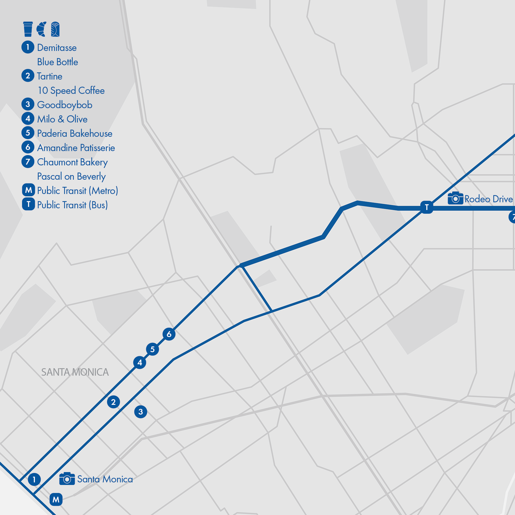
8. Wilshire Boulevard
• Start & Finish: Wilshire Blvd
• Course Profile: 15.8 miles, 516ft; city street sidewalks
Wilshire Boulevard is one of the most prominent streets in Los Angeles, connecting several important business districts of the city. Given the significance of the Wilshire, sidewalks are usually wide and well kept. Running along Wilshire can be a very cool LA experience.
Things to see and visit
- Santa Monica Beach: Wilshire Blvd ends at Ocean Ave on the bluff overlooking the ocean. You can then get down to the beachfront trail.
- Miracle Mile / Museum Row: The prominent stretch is home to several important museums. Don't miss the Urban Light sculpture in front of LACMA and Berlin Wall segments across street.
- Palm Tree Street / Hollywood Sign: Have you seen the Hollywood sign lined up with a palm tree lined street? That is here.
- Koreantown: One of the most diverse and iconic neighborhoods of LA, with a high concentration of restaurants, shopping centers, and metro stations.
- MacArthur Park: The park has a lovely lake and green spaces against LA skyline. Unfortunately homelessness is an issue here.
Additional and alternative routes:
- Continue to Santa Monica oceanfront trail (Route #2)
- Connect to Hollywood or Santa Monica Blvd (Route #7)
- Continue to Downtown LA (Route #6)
Run Clubs /
@koreatownrunclub is a large run club based in Koreatown with four group runs a week
@nightterrorsla does weekly night runs from LACMA
Cafe / Santa Monica: Mid City has better options than the touristy beach area. Check out Goodboybob and 10 Speed for coffee, Paderia, Amandine bakery, Tartine and Milo & Olive for bread and pastries, the latter two offer breakfast and brunch too.
Koreantown: Document Coffee Bar and Yeems Coffee are my favorites coffee shops in Ktown. I also love Asian style bakeries like Paris Baguette and 85°C Bakery.
Transit / LA Metro Purple Line serves the east part of Wilshire between Downtown and Western Ave. Metro Bus 20 and 720 Rapid runs along Wilshire Blvd.

9. Venice Boulevard
• Start & Finish: Venice Blvd
• Course Profile: 13.2 miles, flat; city street sidewalks
Venice Boulevard has the longest bike lanes in LA. It runs 10 miles continuously between the beach and Arlington Ave. While this is not a multi-use bike path, the bike lane creates a buffer between car traffic in the road and the sidewalk, making running on Venice Blvd a little safer and giving runners more space.
Things to see and visit
Venice Boulevard isn't pretty. Except for the west end in Venice Beach, Venice Blvd passes through LA neighborhoods largely unseen by tourists.
- Venice Beach: the beach is known for its broad walk, funky souvnir shops, street artists, and the Muscle Beach. Also check out Abbot Kinney Blvd, the eclectic one-mile street is lined with restaurants, boutiques, galleries and colorful murals.
- Venice Canals: It's exactly what you think it is: canals inspired by Venice, Italy are surrounded by colorful modernist houses.
Additional and alternative routes (west to east):
- Continue to Santa Monica oceanfront trail (Route #2)
- Continue to Marina Del Rey bike path (Route #19)
- Connect to Ballona Creek bike path (Route #19)
- Connect to Exposition Blvd (Route #10)
- Continue to Downtown LA (Route #6)
Cafe / - Downtown Venice features many good cafes, including Menotti's Coffee and Little Lunch a block away from the beach, Intelligentsia, Blue Bottle and Gjelina on the famed Abbot Kinney Blvd.
- Superba Food + Bread: The beautiful bakery cafe with a spacious rustic chic dinning hall and sunny outdoor dining area. It offers everything from coffee to pastry to full breakfast and brunch meals.
- It's not hard to find coffee shops between Venice and Culver City. Check out Röckenwagner and MillCross if you are looking for more than just a cup of joe.
Transit / LA Metro Bus 33 Line runs along Venice Boulevard. Culver City 1 connects Venice beach to downtown Culver City.


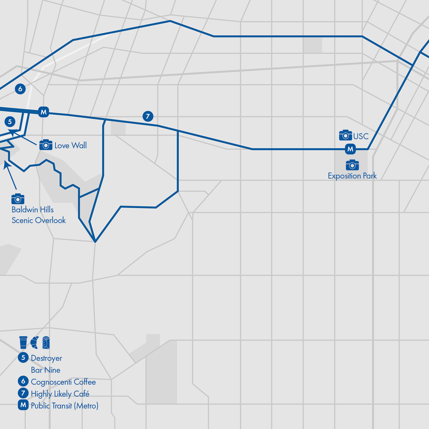
10. Exposition Boulevard

Long Route:
• Start & Finish: Exposition Blvd at Figueroa St, Colorado Ave at Ocean Ave (Santa Monica)
• Course Profile: 13.5 miles, 170 ft+; bike path and city streets
Short Route:
• Start & Finish: Jefferson Blvd at La Cienega Blvd, Colorado Ave at 17th St (Santa Monica)
• Course Profile: 7.0 miles, 160 ft+; mostly bike path
This route largely follows Exposition Boulevard and LA Metro Expo Line. The short route is mostly on a bike path, with a gap between Overland Ave and Palms Blvd. While not very scenic, it's rare to be able to run inside LA and feel so safe and away from cars! The long route extends the short route east to USC and west to the beach.
Things to see and visit
- University of Southern California: A compact campus with most buildings in Romanesque Revival style.
- Exposition Park: The big urban park features a rose garden, multiple museums and sports stadiums.
- Love Wall: Highly instagramable!
- Baldwin Hills Scenic Overlook: Take the Culver City stairs to the hilltop for the fantastic view (see Route #3).
- Downtown Culver City: Tons of restaurants and boutiques on Culver Blvd. Sony Studio HQ is nearby!
- Santa Monica Pier: The landmark is located at the end of Colorado Ave, 1.5 miles southwest of the end of the bike path (see Route #2).
Additional and alternative routes (west to east):
- Continue to Santa Monica oceanfront trail (Route #2)
- Connect to Ballona Creek bike path (Route #19)
- Connect to Venice Blvd (Route #9)
- Connect to Baldwin Hills (Route #3)
- Continue to Downtown LA (Route #6)
Cafe / Mid-City Santa Monica: The bike path ends here. This area is much less touristy than downtown Santa Monica. Check out Tartine and goodboybob coffee.
- Downtown Culver City: There is an abundance of cafés on Culver Blvd. Checkout Citizen Market food court
- Destroyer, Cognoscenti Coffee and Bianca are a few other places I like in Culver City.
Transit / LA Metro Expo Line runs along the majority of this route. The light rail connects downtown Santa Monica and LA!

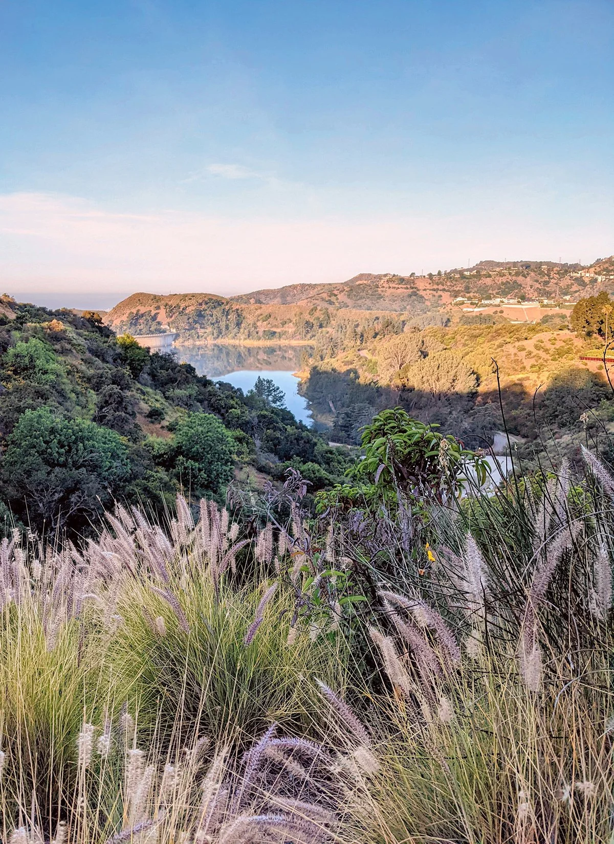
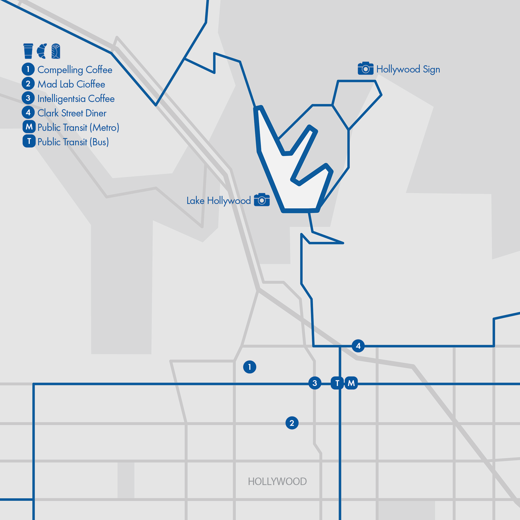
11. Hollywood Reservoir
• Start & Finish: Hollywood Reservoir (South) Trailhead
• Course Profile: (Strava in bio): 3.3 miles, flat; paved road; foot traffic only, trail on street sidewalk for a short segment
Hollywood Reservoir loops is quite a hidden gem. It's embedded in a hillside residential area, with both trailheads a mile or two from main city roads. Once you are on the reservoir trail, you'll be rewarded with great tranquility and scenery. There is a parking lot at the south trailhead. If you could, run in! South trailhead is 2 (hilly) miles from Hollywood Boulevard.
Things to see and visit
Hollywood Reservoir has obstructed views on the south, hence instead of looking outward to the city, look inward to the lake, the hills, the Hollywood Sign.
- Lake Hollywood: Ok, this is just a fancier name for Hollywood Reservoir. The reservoir bank immediately behind the south trailhead/entrance is a great view point. Hollywood sign sits on the hill far behind the lake to the right.
- Hollywood Sign: While Hollywood sign is visible from various points along the reservoir loop (especially the east half), the best and closest spot to see the sign is on Innsdale trail (see additional route above).
Additional and alternative routes:
- On the east half of the loop between south trailhead and Tahoe Dr, there is an alternative trail. It starts shortly after the south trailhead and meets Canyon Make Dr in the north. This is the most scenic route since it's elevated above the reservoir.
- Further north, there is a short dirt trail called Innsdale Trail between Mulholland Dr and Canyon Lake Dr (they are actually the same road with a sharp bend). This is the closest you can get to the Hollywood Sign.
Cafe / Mad Lab: A cute walk-up window that offers the best coffee in Hollywood. A few other decent coffee shops include Compelling Coffee, Intelligentsia Coffee. Clark Street Diner offers pastries and breakfast.
Transit / LA Metro Red Line and Bus 180, 210, 217, 222.
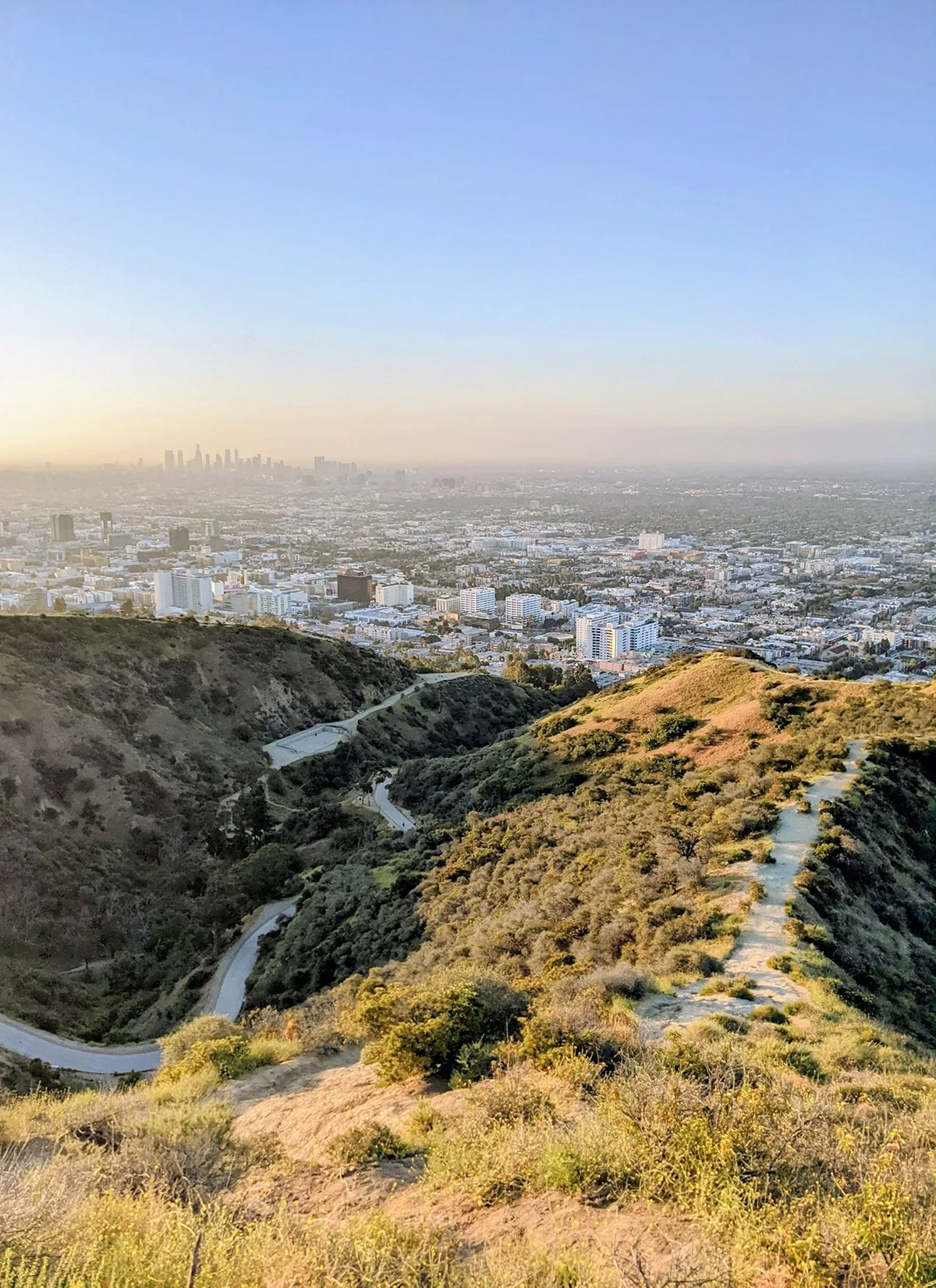
12. Runyon Canyon
• Start & Finish: Park entrance at Fuller Ave
• Course Profile: (Strava in bio): 3.1 miles loop, 850 ft+; soft surface trails and paved road. Foot traffic only.
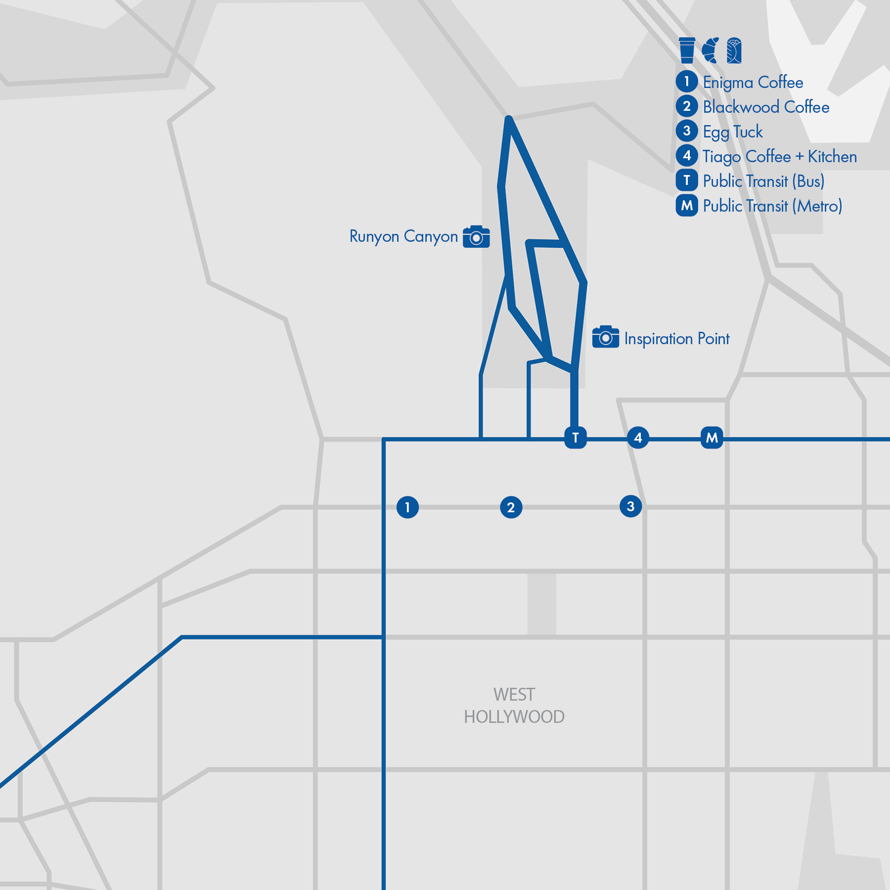
Runyon Canyon is one of my favorite places in LA. It offers fantastic views of Hollywood and it feels more local, likely due to the lack of parking spaces. Fortunately one can easily get here by Metro or bus. Runyon Canyon has two entrances on the south, on Fuller Ave and Vista St. The north entrance is at the top of the hill on Mulholland Dr (lacking sidewalks, not suitable for running).
Between the north and south gates there are two trails and a road. The East and West trails are two ridge trails with the canyon on between. Some parts are steep and there are stairs. The fire road in the middle is paved, with gradual grade and more foot traffic. East trail meets the fire road about two thirds way up. There is a more technical and steeper trail, between half way of West trail and Wattles Garden Park at the lower west side of Runyon Canyon.
The most common route in Runyon Canyon is an out and back loop from the south entrances. Sunrise and sunset time are the best for the spectacular view.
Things to see and visit
Both trails and the fire road have great views. In particular,
- East Trail Inspiration Point: The vista point is right after the first steep climb on East Trail. The proximity to Hollywood gives the best view of the urban life below.
- Hollywood Sign overlook: further up east trail before it meets fire road.
- West Trail Vista Point: Halfway through West Trail at marker W7 where the trail flats out. This is a good spot to take a break and appreciate the view.
Cafe / Egg Tuck: no-frills sandwich joint in a plaza mall. The egg sandwich is served warm, juicy, creamy and tasty. There are a few coffee shops nearby. While I'm not a huge fan of them, they do come handy after a run in the canyon. Blackwood and Enigma have better coffee, Tiago has a larger food menu.
Transit / LA Metro Red Line and Bus 217.
13. Santa Monica Mountains
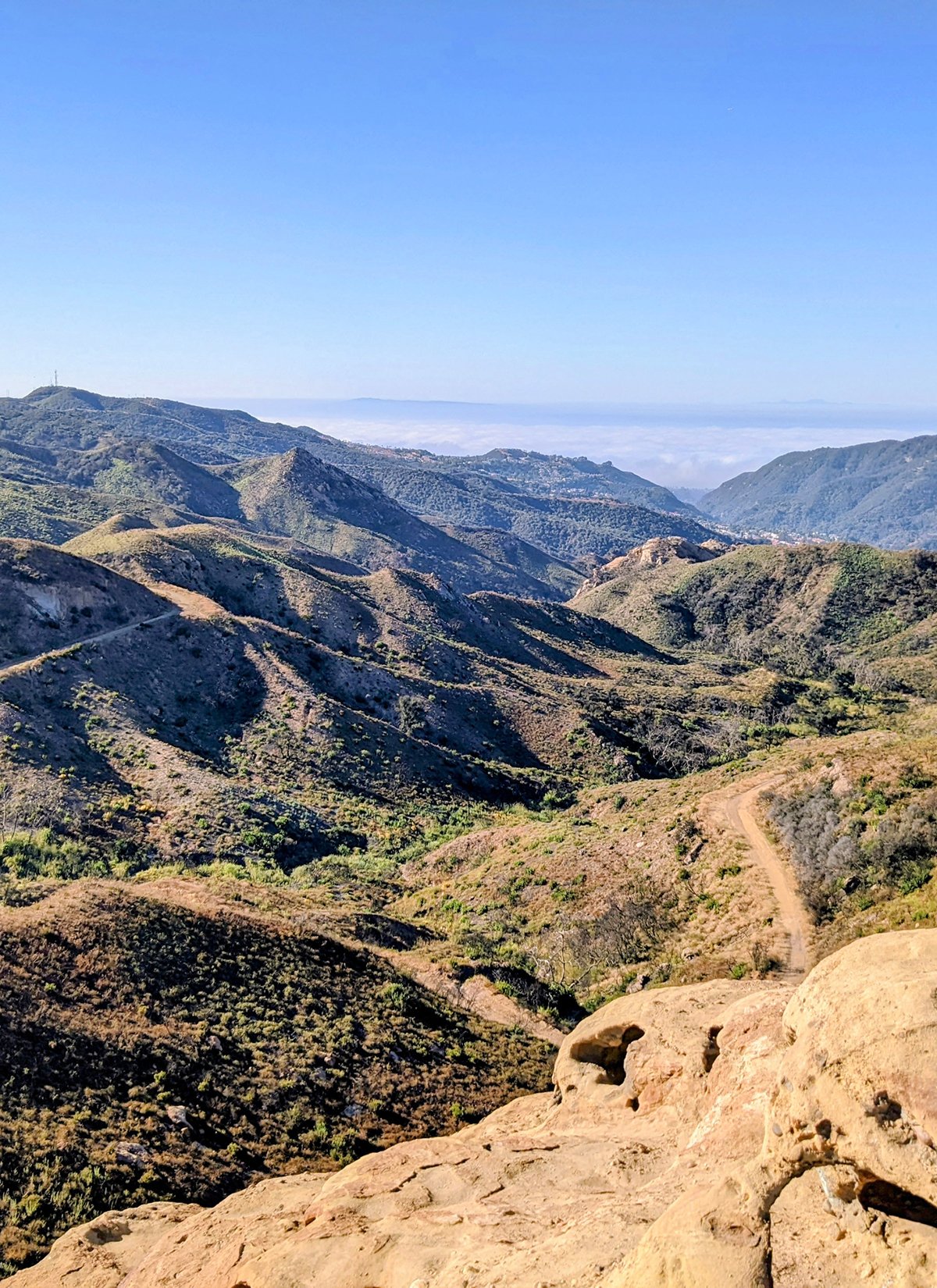
Santa Monica Mountains (SMM) is a mountain range that extends 40 miles west of Los Angeles. There are an abundance of amazing mountain trails, including the 67-mile Backbone Trail, traversing SMM with ~13,000 ft elevation gain. Here are three popular routes that are closest to LA and accessible by public transit or running.
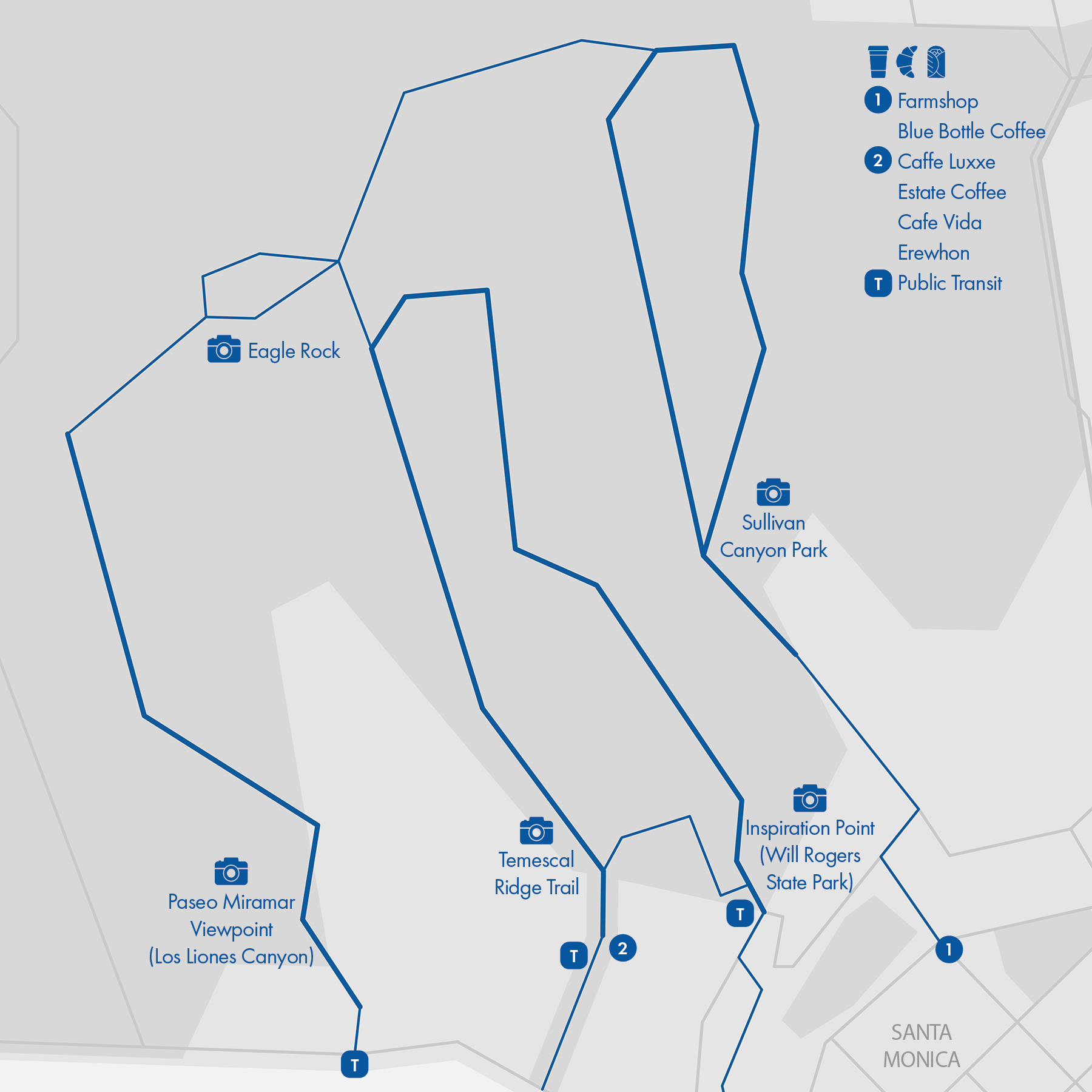
1. Will Rogers State Park / Temescal Ridge Trail (This is the only one that I have done 😜)
• Course Profile (Strava in bio): 12.5 miles, 2540 ft+; soft surface trail
2. Los Liones Canyon (out and back)
• Course Profile (Strava in bio): 13 miles, 2650 ft+; soft surface trail
3. Sullivan Canyon / Westridge
• Course Profile (Strava in bio): 10 miles, 1700 ft+; soft surface trail
Things to see and visit
Trails in Santa Monica Mountains are beautiful. The whole run would be scenic and one doesn't have to particularly look out for nature's beauty, it's everywhere.
- Eagle Rock: This big sandstone rock can be reached via both Temescal and Los Liones trailheads, though it's several miles and 2000 ft+ in anyway. Also the rock looks more like an elepant than an Eagle, if you wonder, it's simply named after the Eagle Spring nearby.
- Inspiration Point (Will Rogers State Park: The viewpoint is just half a mile in from the Backbone trailhead, with a sweeping view of the west side of LA.
- Temescal Ridge Trail: there are a few points of interest along the trail, including viewpoints, a waterfall, and skull rock.
- Paseo Miramar Viewpoint: One mile and half up Sunset Blvd in Los Liones Canyon, there is a nice viewpoint overlooking Pacific Palisades and Santa Monica.
Cafe /
- Farmshop: Rustic restaurant & cafe that offers coffee, house baked pastries, hot breakfast and a huge selection of provisions.
- Blue Bottle Coffee: I'm never a fan of Blue Bottle but if that's the only option, I don't mind getting an iced latte.
- Palisades Village at the gateway to Temescal Canyon has a few coffee shops, cafes, and an upscale grocery.
Transit / Served by LA's Metro buses and Santa Monica's Big Blue Bus.
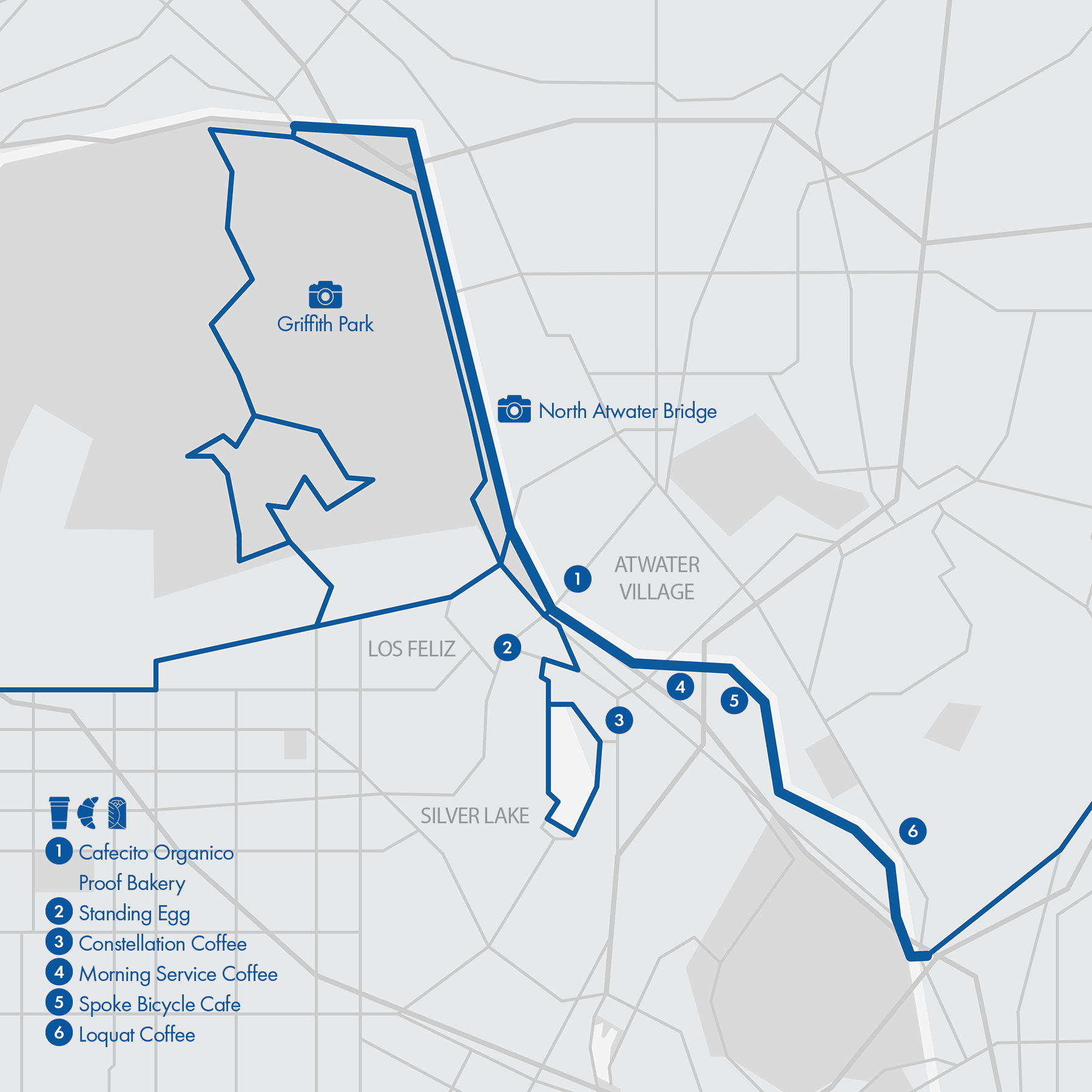
14. LA River Trail
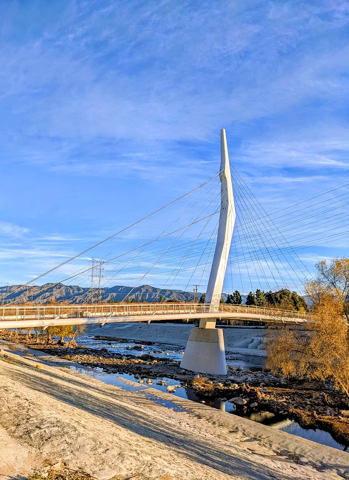
• Start & Finish: Riverside Dr at Figueroa St & Riverside Dr at Zoo Dr
• Course Profile (Strava in bio): 7.5 miles, 200 ft+; paved multi-use path; no traffic
LA River Trail is my favorite place for tempo runs. It's long, relatively straight and flat (very slight uphill going north), and completely car free. The 3.2 miles north of Los Feliz Blvd has little trail traffic but it's lacking amenities. The 4.3 miles south of Los Feliz Blvd is a lot busier, especially on the weekend. It's next to a residential area and even has a few cafés along the trail.
While the trail scenery is open and pleasant, there aren't a lot to see. The North Atwater Bridge (cover) and newly opened bright orange Taylor Yard Bridge (P6) are the most picture worthy spots.The surrounding neighborhoods of LA River Trail, Atwater Village, Los Feliz, Silver Lake, and Frogtown are all relaxing with charming.
Alternative and longer routes:
- Connect to Griffith Park (Route #1). On the north, there are several Griffith Park trailheads just west of LA River trail end; on the south, take Los Feliz Blvd.
- Connect to Silver Lake Reservoir (Route #5) from Hyperion Ave or Fletcher Dr.
- Follow Figueroa St after the south trail end to Arroyo Seco Bike Path (Route #16)
Cafe /
- Cafecito Organico: small, no-frills neighborhood coffee spot.
- Proof Bakery: one of the best bakeries in LA, check out their za'atar croissant. Proof offers coffee, pastries, sandwiches in a small shop with a couple of tables outside.
- Constellation Coffee: a hidden gem in Silver Lake, excellent coffee and service See Route #5.
- Morning service Coffee: a coffee equipment showroom and shop with a cozy and sunny patio, and makes the best coffee out of the few shops along the trail.
- Spoke Bicycle Cafe: a trail users' favorite, especially among cyclists. It has a large patio with plenty of seats, offering everything from coffee to burritos.
- Loquat Coffee: fantastic coffee shop with a small but intentional menu. See Route #15.
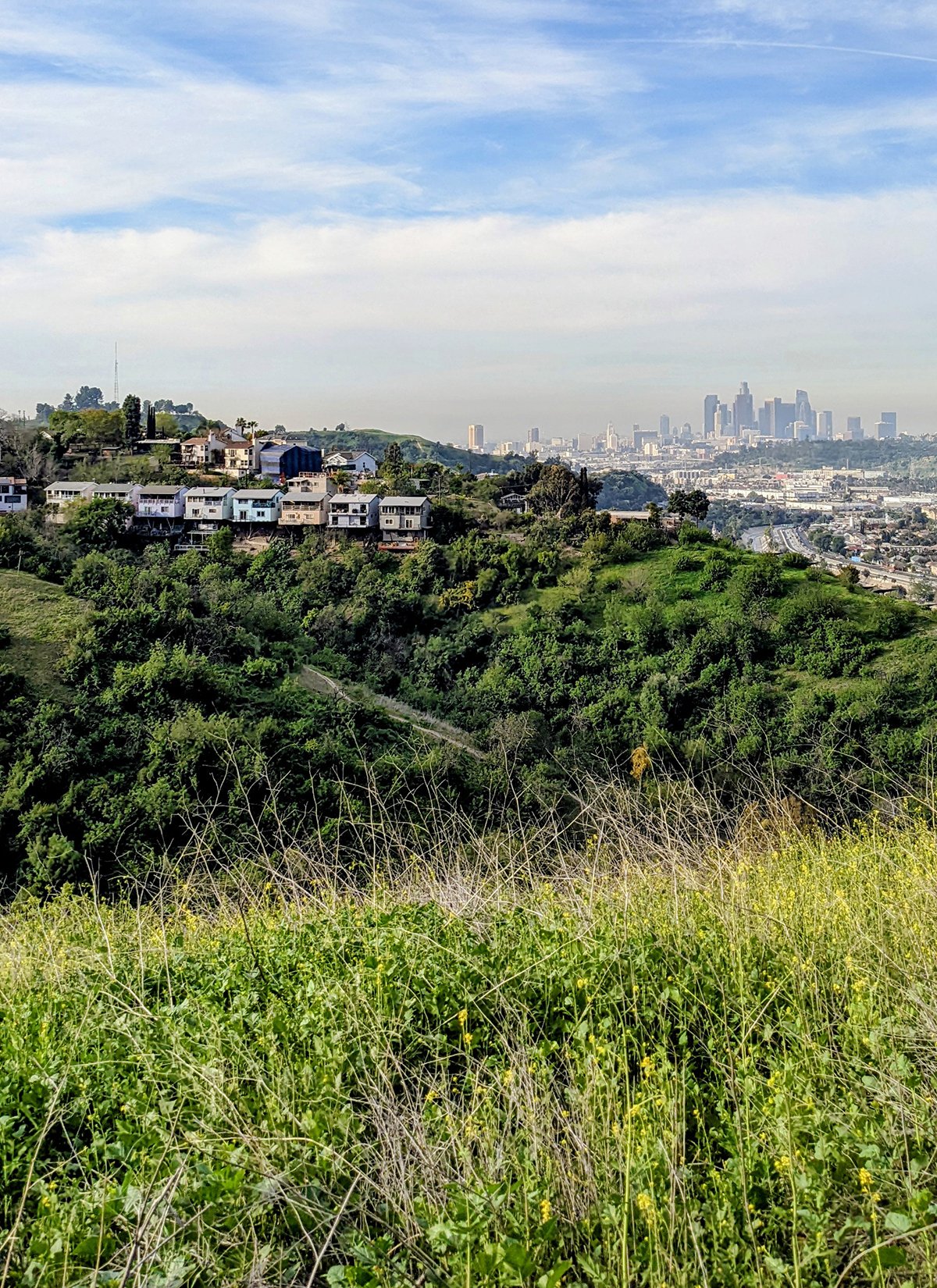
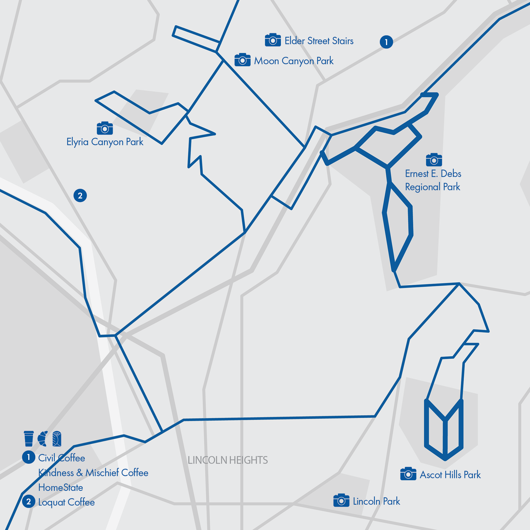
15. Northeast Hills
• Start & Finish: Various points and trailheads
• Course Profile (Strava in bio):
Ernest E. Debs Regional Park (loop): 3.7 miles, 900 ft+; dirt trail, no traffic
Ascot Hills Park (loop): 1.8 miles, 485 ft+; dirt trail, no traffic
Mt. Washington (loop): 6.0 miles, 1070 ft+; city street and dirt trail, low traffic
[Overview]
Los Angeles doesn't end at LA River. East of the river, Northeast LA's landscape is dominated by rolling hills and interesting neighborhoods like Highland Park and Lincoln Heights that are too often overlooked by the westsiders.
Ernest E. Debs Regional Park and Ascot Hills Park are two major parks in the area. Both feature interconnected hilly trails that span the whole park. Mt. Washington is a hillside residential neighborhood with several smaller nature parks and hilltop viewpoints.
Things to see and visit
- Ernest E. Debs Regional Park: a large open space with native California walnut and oak woodlands and a small lake. Check out the city view (cover) from the Northwest hilltop.
- Ascot Hills Park: Great views of LA skyline from the west hill of the park. Be aware: south of Ascot Reservoir the trail is extremely steep.
- Elyria Canyon Park: a nature park with a few trails.
- Moon Canyon Park: a small grassed canyon with one through trail.
- Sea View Lane: a short and scenic hillside trail.
- Eldred Street: with 33% grade over 400 feet, it is one of the steepest streets in the country and recently featured in @trialsofmilesracing races
- Lincoln Park: one of LA's first parks with a charming lake in the center.
Alternative and longer routes:
- Continue to LA River Bike Path (Route #14) through Figueroa St.
- Continue to Arroyo Seco Bike Path (Route #16) near Ernest E. Debs Regional Park.
Run Club / @tofu_scramble_run often runs these hills and trails
Cafe /
- Loquat Coffee: the bright yellow coffee shop is one of Kumquat Coffee's own coffee roaster and showroom cafe, with a concise and creative menu.
- Figueroa St and Broadway have plenty local restaurants
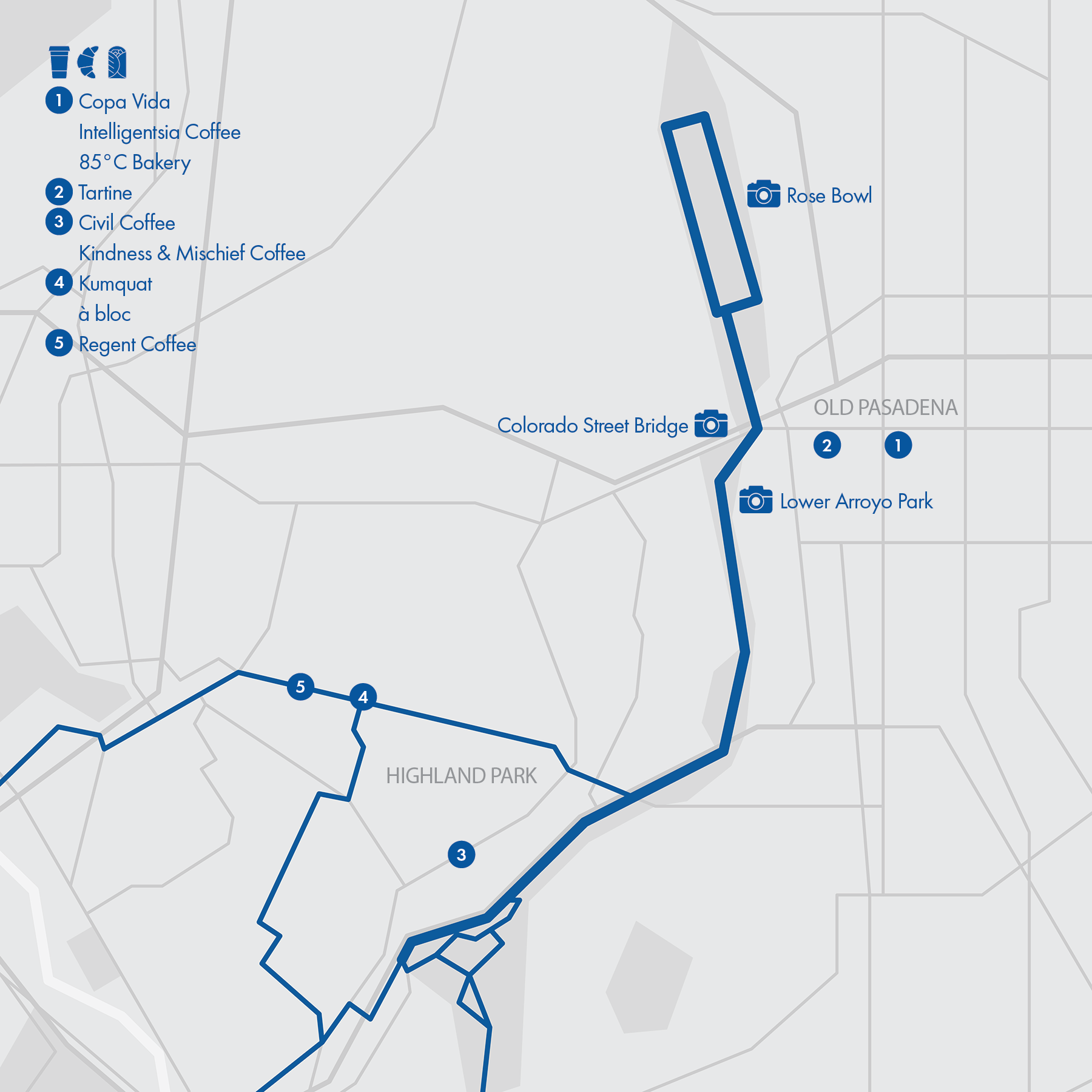
16. Arroyo Seco - Rose Bowl
• Start & Finish: Montecito Recreation Center & Rose Bowl
• Course Profile (Strava in bio):
Arroyo Seco: 6 miles, 465ft+; multi-use path south of San Pascual Park, dirt trail to Rose Bowl; no traffic.
Rose Bowl Loop: 3.15 miles, 100ft+; pedestrian lane on city street.
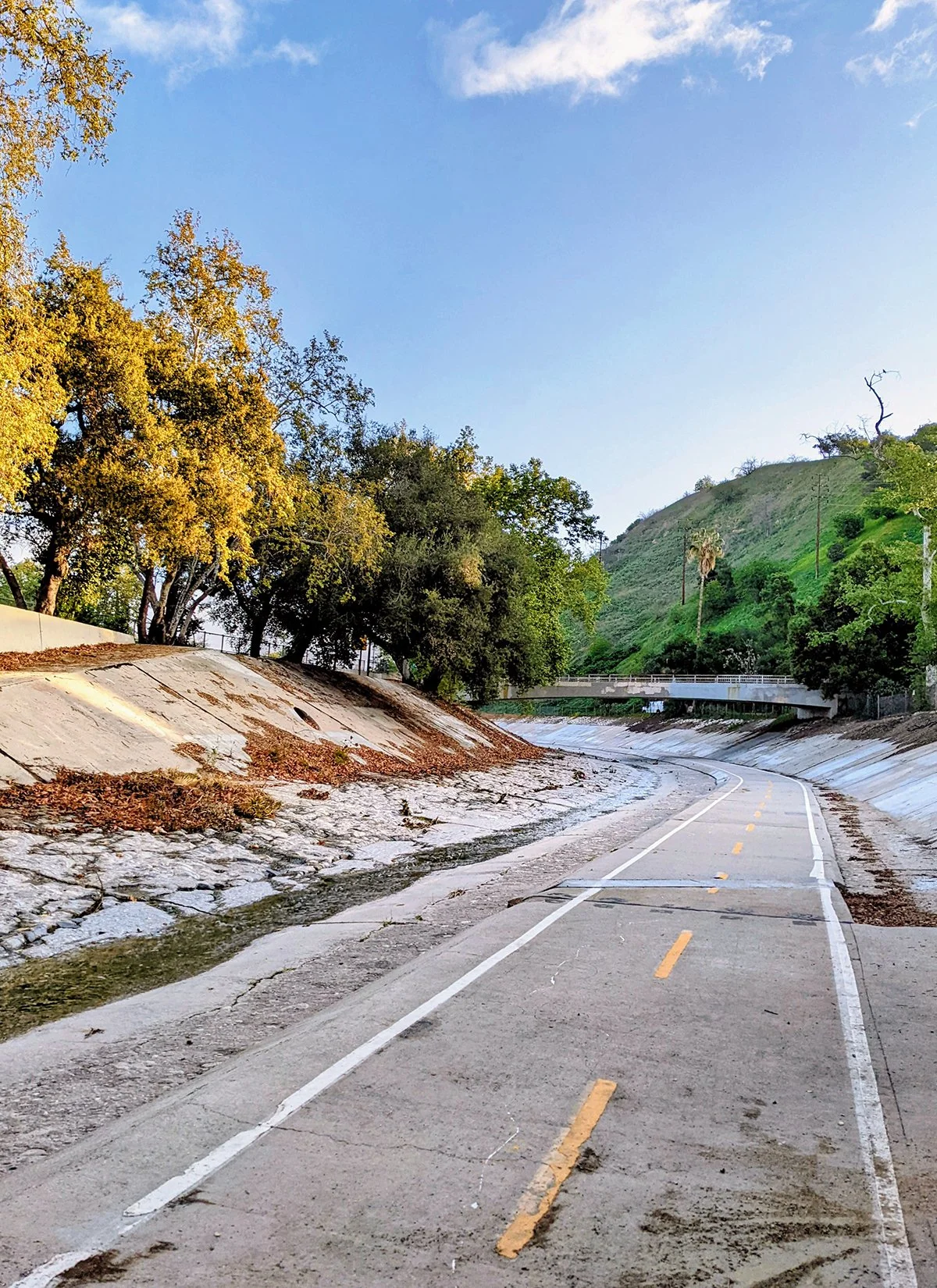
Arroyo seco is a dry gulch off LA River. A bike path runs along the river, with part of it on the riverbed (cover, P6). The bike path becomes dirt trail north of San Pascual Park in the ravine of Lower Arroyo Park and connects Rose Bowl. This segment has frequent foot traffic. As Arroyo Seco trail ascends to street level, it reaches the south end of Rose Bowl Loop, a popular rectangular walking and running route. A wide pedestrian lane is marked next to road traffic and is easy to follow.
Things to see and visit
- Rose Bowl: a national historic landmark and one of the most famous sports venues, especially known for American college football Rose Bowl Game.
- Colorado Street Bridge: a historic bridge with distrinct Beaux Arts arches above Arroyo Seco.
- Lower Arroyo Park: a tranquil natural preserve area with hiking trails and an archery range.
- Highland Park: a low-key, charming neighborhood with local life along Figueroa St and on York Blvd.
- Old Pasadena: a lively, slightly quaint shopping area along Colorado Blvd with a ton of cafés and boutiques.
Alternative and longer routes:
- Connect to Ernest E. Debs Regional Park (Route #15) through various trailheads.
- Continue southwest to LA River Trail (Route #14) through Figueroa St.
Run Clubs /
Highland Park: @highlandparkrunners / @tofu_scramble_run
Rose Bowl: @pasadenapacers
Cafe /
- Kumquat Coffee serves one of the most high-quality and creative coffee in LA.
- Civil Coffee has a spacious space and a lovely patio, offering everything from coffee and pastries to breakfast toasts and burritos.
- Copa Vida is a coffee shop with a convivial atmosphere, ample indoor seatings, and a menu that features delicious breakfast items.
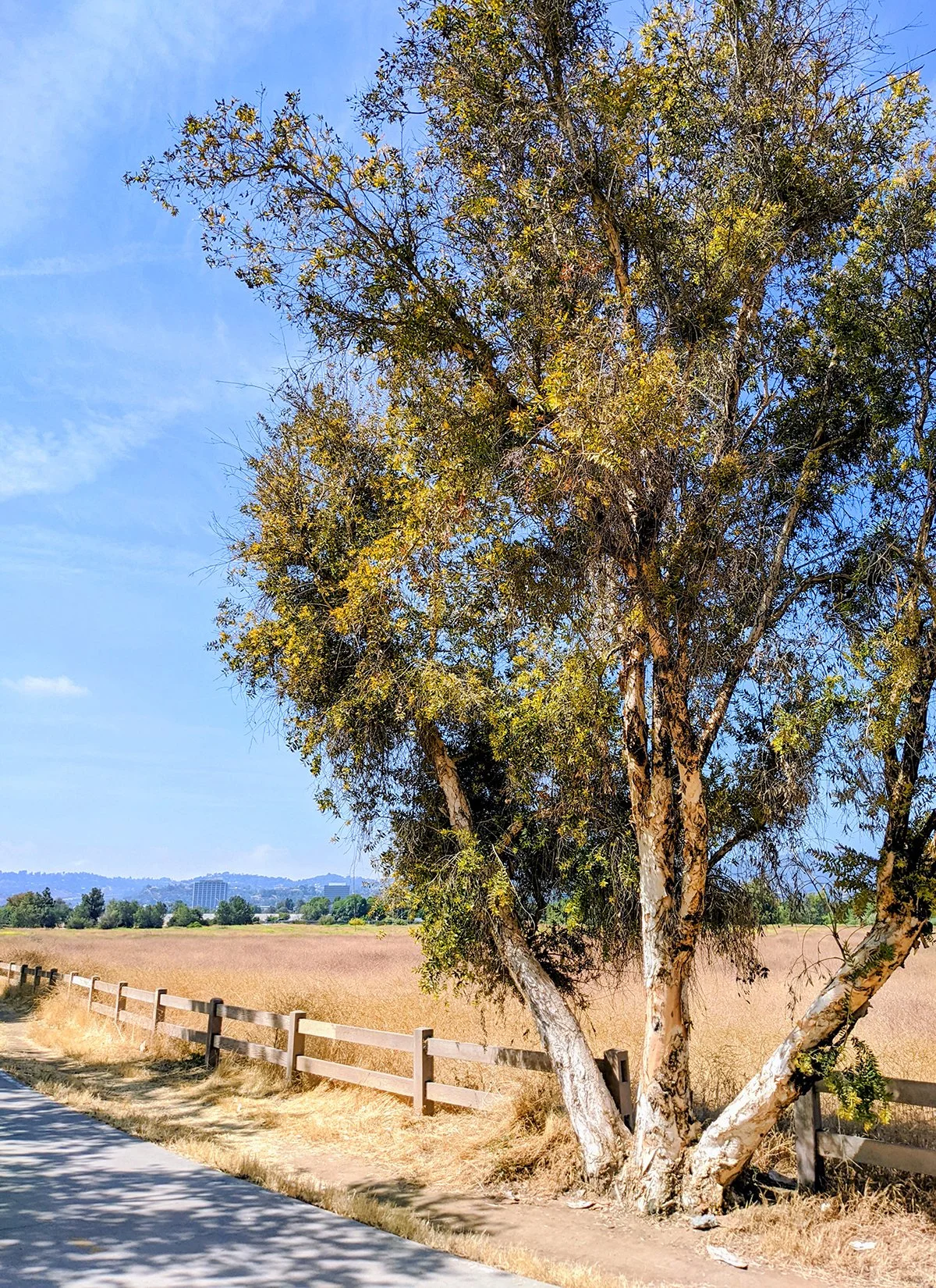
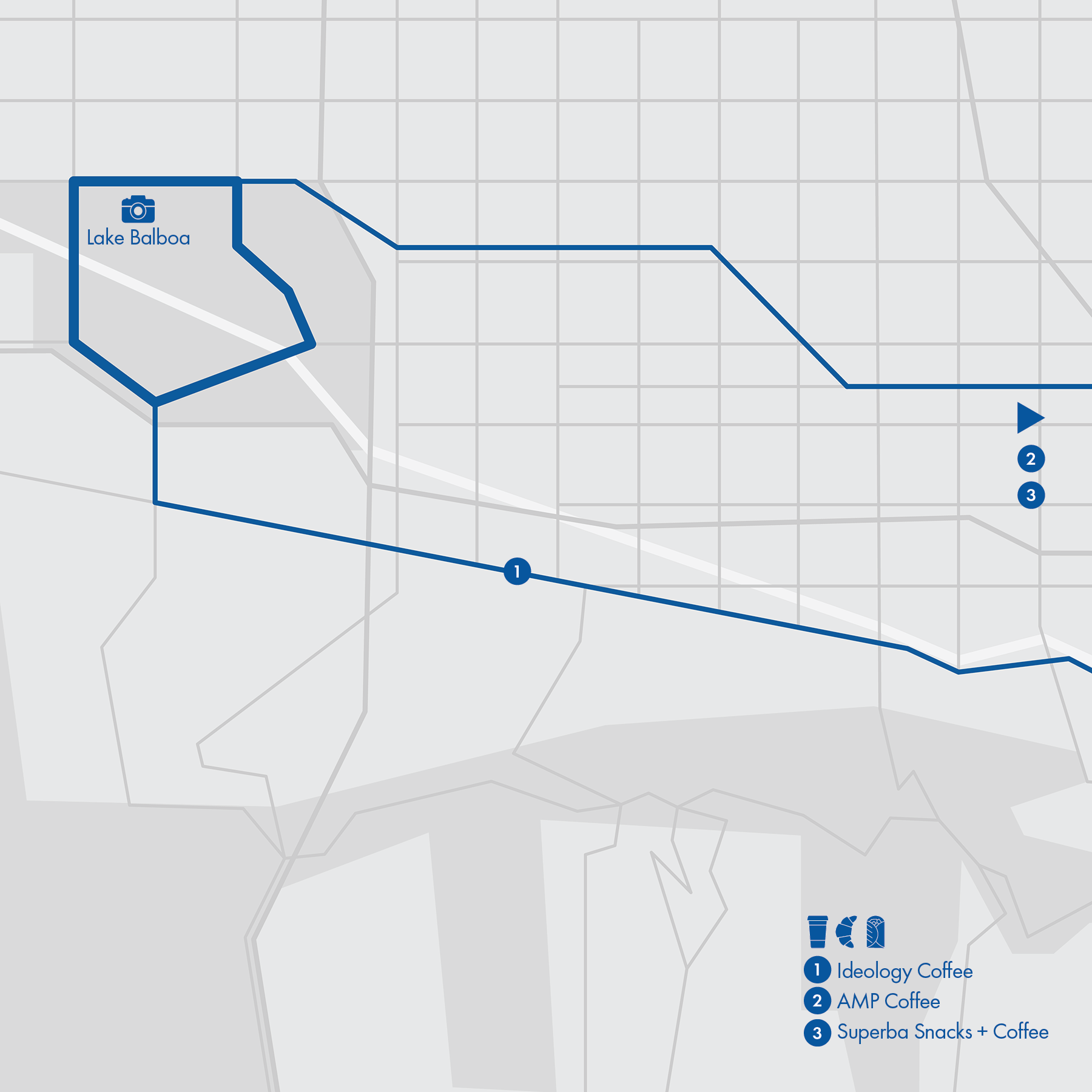
17. Sepulveda Basin
• Start & Finish: anywhere along the loop
• Course Profile: 5.5 miles, flat (Strava route in bio)
• Surface: multi-use path
• Traffic: none to minimal
This 5.5-mile multi-use loop around the Sepulveda Basin Recreation Area is the most popular urban running route north of Hollywood Hills. Ok, I've only done this once and I missed Lake Balboa but I think it's important to feature at least one route in this area. Lake Balboa: a small lake with a loop trail in the Sepulveda Basin Recreation Area, famous for its cherry blossom (early March)
Alternative and longer routes:
- Continue east via Orange Line bike path and Chandler Blvd to North Hollywood and Downtown Burbank. This is a quiet route with low traffic.
- Continue east via Ventura Blvd. This is a vibrant local street with lots of business and traffic.
Run Club / @valley_ttrc and Fleet Feet Encino have group runs in the area.
Cafe / I didn't try places near Sepulveda Basin, so my recs are on Ventura Blvd and especially in North Hollywood...
- Ideology Coffee: bright and inviting, decent coffee (much better than the nearby Tortoni Caffe in my opinion).
- Amp Coffee: A coffee bar located in the AMP rehearsal studio in North Hollywood. It serves the best coffee in NoHo, and is pretty quiet in the morning since the studio opens late in the morning.
- Superba Snacks + Coffee: A sunny stand in the heart of NoHo, serving coffee, pastries and breakfast sandwiches/burritos.
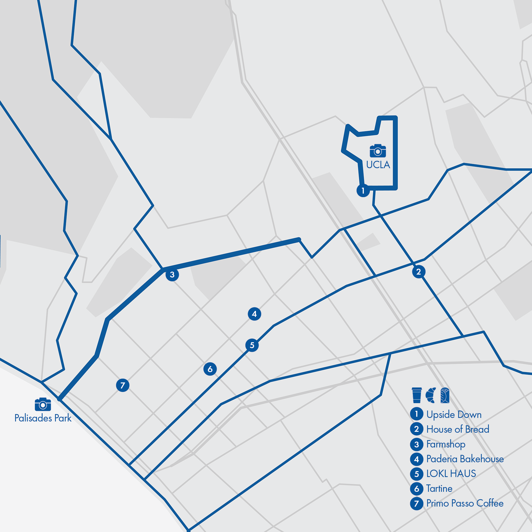
18. San Vicente Blvd - UCLA
• Start & Finish: anywhere along San Vincente Blvd
• Course Profile: 3.8 miles, flat (Strava route in bio)
• Surface: city street
• Traffic: medium
The northern part of Santa Monica, especially along San Vicente Blvd, is popular for local runners. San Vicente Blvd (P6) has a green belt median and bike lanes in both directions for the entire 3.8 miles. A mile and half east, UCLA campus is another great spot for an easy jog.
Things to see and visit
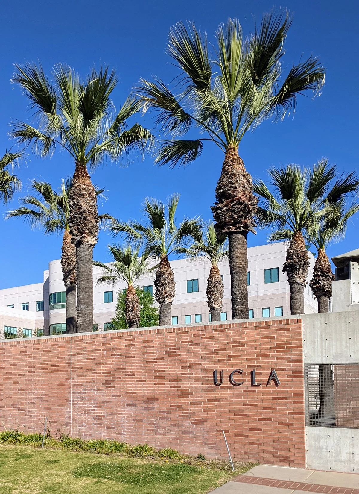
- UCLA Campus: The campus has the Romanesque style that matches the sunny weather of Southern California. Check out Dickson Court in particular.
- UCLA (Franklin D. Murphy) Sculpture Garden: A few dozens of sculptures of different sizes, styles and materials are nicely integrated into an open space.
- UCLA (E. Mathias) Botanic Garden: There are a few short trails in this small hillside garden so people can take a stroll and relax.
- Palisades Park: A narrow park on a bluff with palm tree lined walking path and great views of the ocean. There are stairs to get down to the beach.
Alternative and longer routes:
- North of San Vicente Blvd there are plenty of trails, of which the closest is Will Rogers State Park (Route #13).
- At the west end of San Vicente Blvd, continue on oceanfront bike path to Pacific Palisades, Santa Monica, or Venice Beach (Route #20).
- Run around in the quiet neighborhood north of Montana Ave.
Cafe /
- Upside Down: A donation based coffee shop that offers signature coffee drinks, pastries, and a relaxing space.
- Farmshop: At the same time a bakery, a restaurant, and a market, Farmshop has a lot to offer. I'm not a big fan of their pastries but this is the best you can have along San Vicente Blvd.
- Primo Passo Coffee: A decent local shop to sip coffee and hang out.
- House of Bread: Signature pastries are croissants and banana bread.
- Tartine: A chic bakery cafe that offers coffee, pastries, toasts, and breakfast.
- LOKL HAUS: Coffee, pastries and breakfast in a quiant little shop.
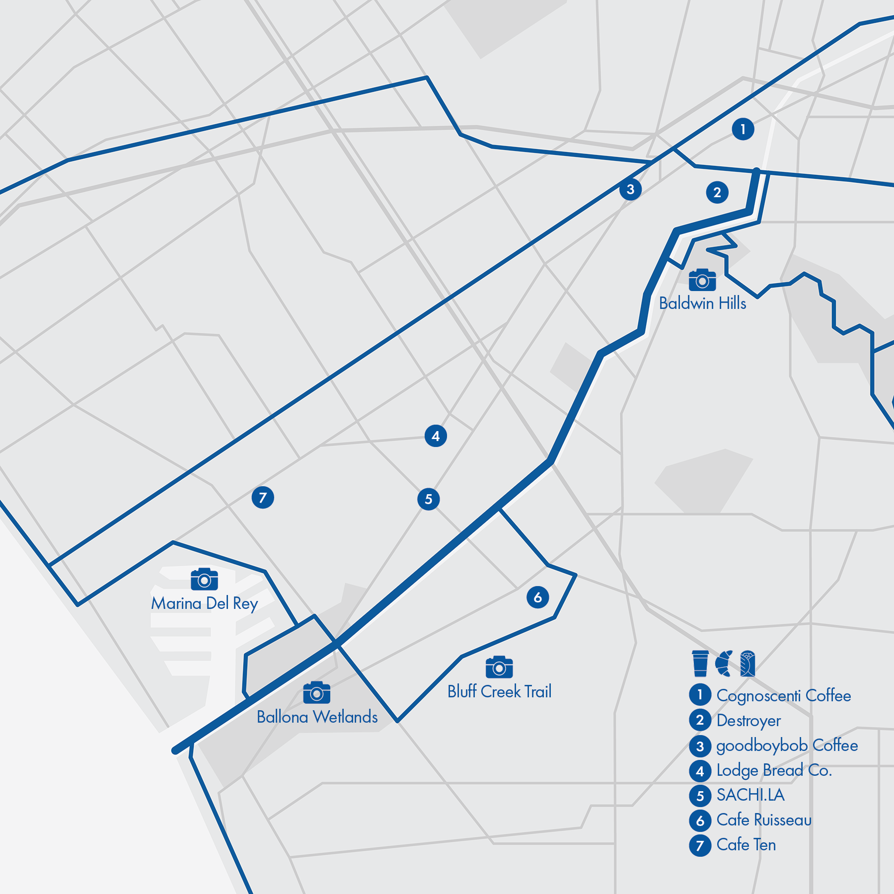
19. Ballona Creek Trail
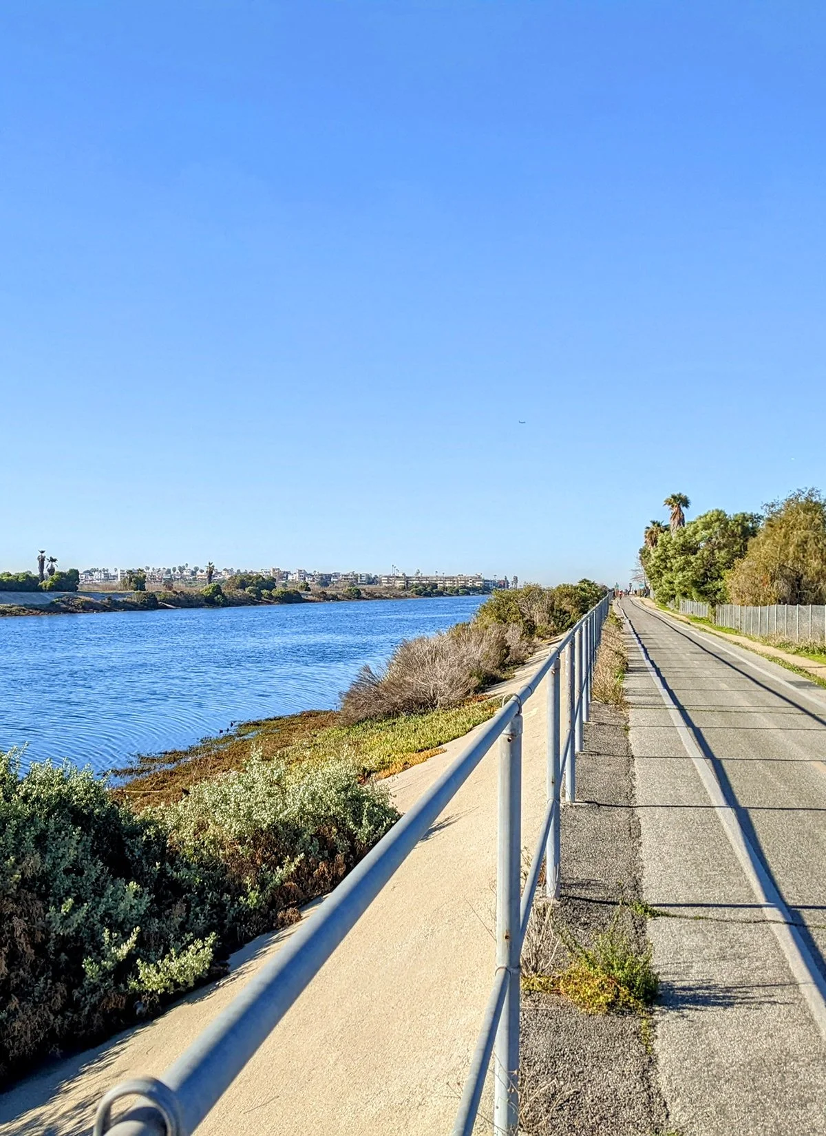
• Start & Finish: Syd Kronenthal Park & Pacific Ocean
• Course Profile: 6.9 miles, flat (Strava route in bio)
• Surface: multi-use path
• Traffic: none
[Overview] This bike path just under 7 miles connects Culver City and Marina Del Rey and runs on the north bank of Ballona Creek. The creek, a narrow waterway in Culver City, gets wider as it goes southwest and becomes a river as it goes into the Pacific Ocean. This path is easy to follow. The most scenic segment of the trail is along the Ballona wetlands. Also check out Bluff Creek Trail and Marina Del Rey Harbor.
Alternative and longer routes:
- Bluff Creek Trail. The 2-mile dirt trail on a bluff is a popular hiking and dog walking trail for the locals. Under the bluff are a series of public parks and a nature park.
- At the southwest end, continue south to Beach Cities (Route #20).
- Near the southwest end, use Marvin Braud Bike Path to continue to Venice Beach.
- Near the northeast end, use Duquesne Ave to continue to Culver City Steps and Baldwin Hills (Route #3).
- At the northeast end, continue to Exposition Blvd Bike Path (Route #10)
Cafe /
- Destroyer: A daytime spot for casual yet inventive European fare, besides coffee and pastry.
- Cognoscenti Coffee: A small coffee shop in Culver City's Arts District, decent coffee and great pastry from Friends & Family.
- SACHI.LA: Co-located with a record store, this Japan inspired coffee shop has a comforting space withk patio and serves great coffee.
- Goodboybob: coffee shop with breakfast wraps located in the citizen Market.
- Lodge Bread: the fantastic croissant is worth the detour from Ballona Creek.
- Cafe Ruisseau: this local ship has a chill vibe and plenty of seats in open air.
- Cafe Ten: a hidden gem that offers breakfast fare in a modern cafe.
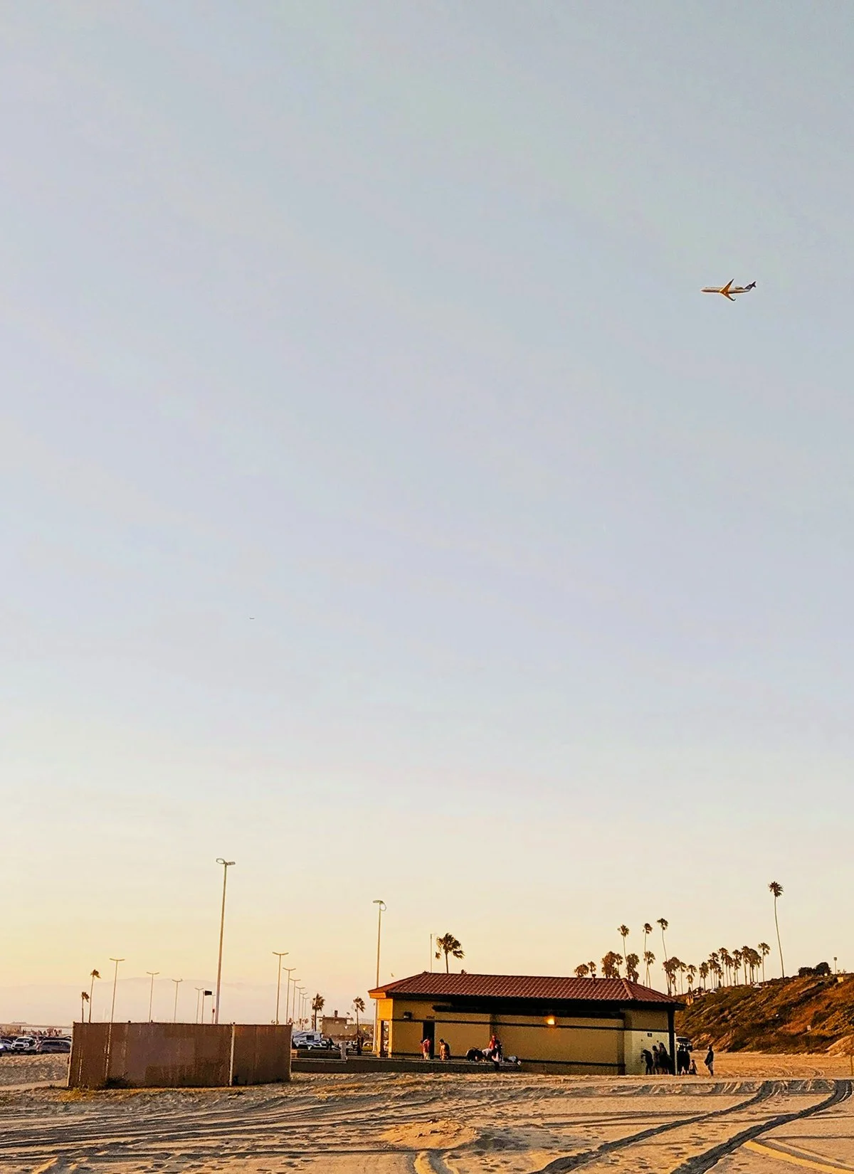
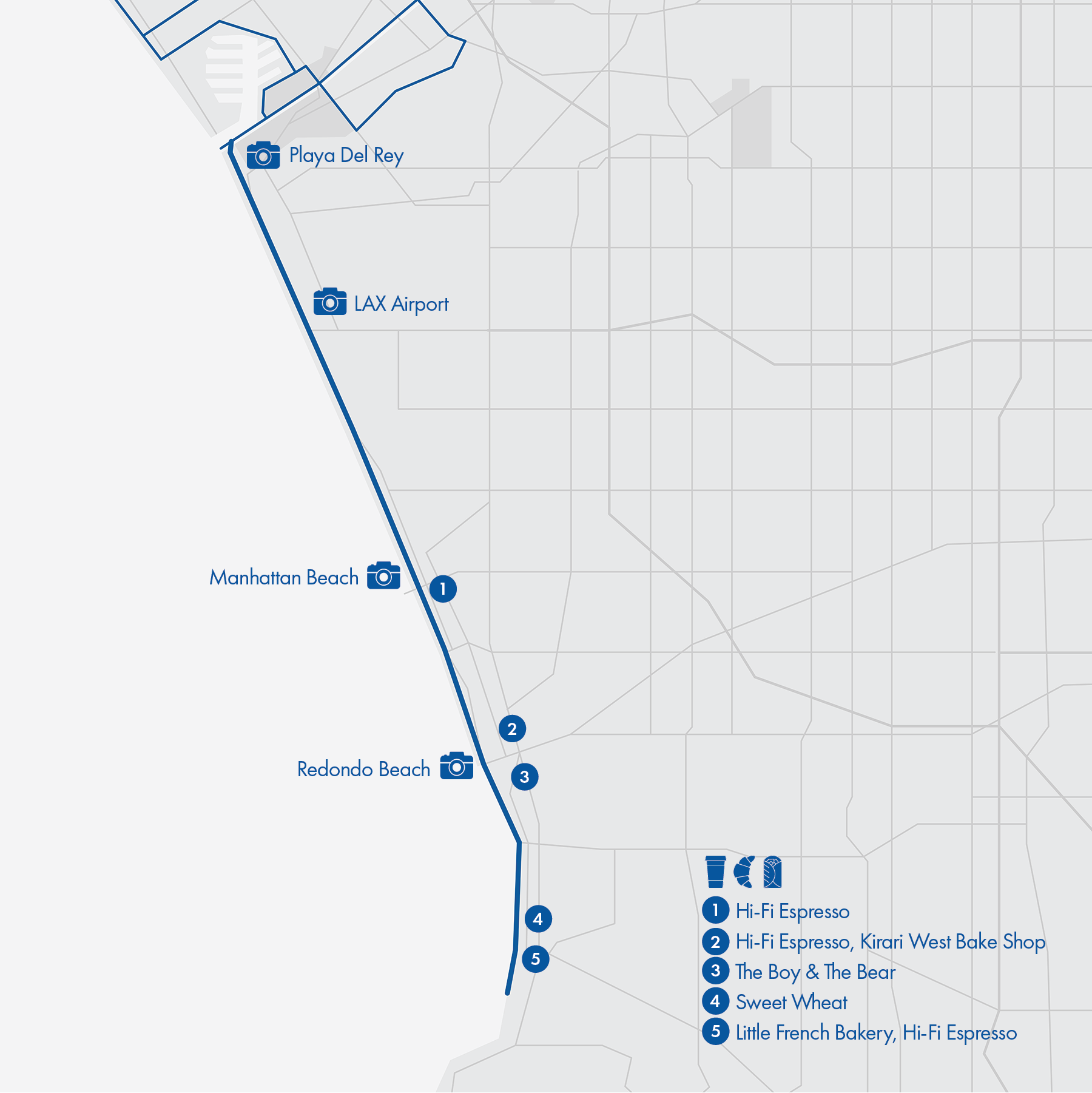
20. Beach Cities
• Start & Finish: anywhere along the path
• Course Profile: 11.6 miles, flat (Strava route in bio)
• Surface: multi-use path, city street
• Traffic: low
This 11.6-mile route is mostly shared with bikes, as part of the Marvin Braude Bike Trail along the Pacific Ocean (although I never heard locals using this name). The route passes a series of beaches, from north to south: Playa Del Rey Beach, Dockweller Beach, El Segundo Beach, Manhattan Beach, Hermosa Beach, Redondo Beach, and Torrance Beach.
It's fairly easy to follow the multi-use path with two exceptions. Within Manhattan Beach city limit, the path becomes bikes only and runners will use the upstairs pedestrian street called "The Strand". Also, the path disappears in Redondo Beach Pier area, just follow the pathway along the ocean.
Alternative and longer routes:
- Continue north on Ballona Creek Bike Path (Route #19)
- Switch to Hermosa Valley Greenbelt (along Valley Dr) between Manhattan Beach and Hermosa Beach
Run Clubs / Check out @villagerunner
Cafe /
- Hi-Fi Espresso (Hermosa Beach): family-owned, beach-vibe local coffee chain with three shops spread out in beach cities.
- The Boy & The Bear Coffee Rostery ,(Redondo Beach): A three-store local chain that first opened in Redondo Beach in 2016 and serves Colombian coffee.
- Little French Bakery (South Redondo Beach): a small bakery that makes fantastic croissants, try their weekly special flavors.
- Sweet Wheat Bakery (South Redondo Beach): huge selection of baked goods and sandwiches, with plenty of indoor and patio seatings.
Run Clubs
1. Adidas Runners
Website / Various time and locations, check website for details.
2. Angel City Run Club
@angelcityrunclub / Wed PM @ DTLA, Fri AM @ Culver City
3. Blacklist LA
@blacklistla, Website / Multiple runs a week from various locations.
4. Boyle Heights Bridge Runners
@boyleheightsbridgerunners / Wed PM @ Mariachi Plaza
5. Breakfast Run Club
@thebreakfastrunclub, Website/ Mon AM, Thu AM, Fri AM @ Norman O Houston Park
6. Brews Brothers Run Club
@brewsbrothersrunningclub_noho / Wed PM @ Brews Brothers (NoHo)
7. Dog Haus Run Club
@doghausrunningclub / Tue PM @ Dog Haus Biergarten (Pasadena)
8. DTLA Run Club
@dtlarunning, Website / Tue PM, Thu PM @ The Bloc (DTLA)
9. Eagle Rock Run Club
@eaglerockrunclub, Website / Thur PM @ Walt's Bar (Eagle Rock)
10. East LA Runners
@eastlarunners / Tue PM @ Belvedere Park
11. Fleet Feet
@fleetfeet_burbank_encino, Website / Multiple runs a week in various locations.
12. Glendale Runners
@glendalerunners / Tue AM @ Adams Hill
13. Good Vibes Track Club
@goodvibes_tc / Tue PM TRK, Thu PM, Sat AM @ Various locations
14. Hard Knocks Run Club
@hardknocksrunclub / Tue PM @ Santa Monica
15. Highland Park Run Club
@highlandparkrunners / Tue PM @ York Park (Highland Park)
16. Koreatown Run Club
@koreatownrunclub, Website / Mon PM, Wed PM TRK, Thu PM, Sat AM @ Various Locations
17. LA Craft Runners
@la.craft.runners / Tue PM @ Rotating Breweries
18. LA Front Runners
@losangelesfrontrunners, Website / Multiple runs a week, check website for details.
19. LA Rebels
@larebels / Tue PM TRK @ Lincoln MS
20. Los Feliz Running Club
@losfelizrunningclub / Sun AM @ Griffith Park
21. LSD (Long Slow Distance)
@lsd_running / Wed PM @ Store
22. Mikkeller Run Club
@mrc_losangeles / Multiple runs a week from various breweries
23. Movement Runners
@movementrunners / Tue PM @ Playa Vista, Wed PM & Fri AM @ Culver City, Sun Am TRL
24. Night Terrors Run Club
@nightterrorsla / Wed PM @ LACMA
25. November Project LA
@novemberprojectlax / Wed PM @ Griffith Observatory
26. Pasadena Pacers
@pasadenapacers, Website / Tue PM, Thu PM, Sat AM @ Rose Bowl (PAsadena)
27. Queer Run Club
@queerrunclubla, Website / Mon PM @ Rotating locations
28. Run Away for My Problem
@runwithramp / Wed PM, Sat AM @ Woodbridge Park (Studio City)
29. Run With Us
@runwithuspasadena, Website / Mon PM @ Store
30. Rundaley
@rundalay / Mon PM @ Grand Park, Fri PM @ Griffith Park
31. Silver Lake Track Club
@silverlaketrackclub, Website / Tue PM & Sun AM @ Silver Lake, Thu PM TRK @ Memorial Stadium
32. Skid Row Running Club
@skidrowrunningclub, Website / Mon AM & Thu AM @ Midnight Mission
33. South Central Run Club
@southcentral.run, Website / Thu PM & Sun AM from various locations.
34. Sunday Runday LA
@sundayrunday_la, Website / Sun AM @ DTLA
35. Tempo Running Track Club
@valley_ttrc / Wed PM @ Lake Balboa
36. Tofu Scramble Run Club
@tofu_scramble_run / Fri AM @ Rotating locations in East Side
37. Track Club LA
@trackclubla, Website / Tue PM TRK @ Santa Monica College, Sat AM @ Brentwood
38. Venice Run Club
@venicerunclub / Tue PM TRK @ Culver City HS, Wed PM & Sat AM @ Venice
39. WeHo Run Club
@weho.runclub / Thu PM @ The Pink Wall
Local Expert: LA Running Connoisseur
Stores
1. Fleet Feet Burbank
@fleetfeet_burbank_encino, Website / two stores in Burbank and Encino.
2. Front Runners
Website / two stores in Brentwood and Torrance.
3. Heartbreak Hill Running company
@heartbreak.la, Website / 2430 Main St, Santa Monica, CA 90405
4. LSD Long Slow Distance
@lsd_running, Website / 1539 Echo Park Ave, Los Angeles, CA 90026
5. Road Runner Sports
@roadrunnersports, Website / two stores in Santa Monica, Studio City, Torrance
6. Run With Us
@runwithuspasadena, Website / 235 N Lake Ave, Pasadena, CA 91101
Brand Houses
1. HOKA
three stores in West Hollywood, Venice, and Studio City.
2. New Balance
four stores in Santa Monica, Brentwood, Silver Lake, and Pasadena.
3. Nike
two stores in The Grove and Santa Monica, several Well Collective stores and outlets in the region.
Races
1. The McCourt Foundation Events
Los Angeles Marathon
@lamarathon / Marathon/ March / Los Angeles
LA Big 5K
5K / March / Los Angeles
Santa Monica Classic
10K, 5K / September / Santa Monica, CA
Rose Bowl Half & 5K
Half Marathon, 5K / January / Pasadena, CA
Coffee & Cafe
1. Amp Coffee
@ampcoffeela / 5259 Lankershim Blvd, North Hollywood, CA 91601
2. Bar Nine
@barninecoffee / 3515 Helms Ave, Culver City, CA 90232
3. Constellation Coffee
@constellationcoffeela / two locations in Silver Lake and Glendale.
4. Copa Vida
@copa_vida / multiple locations in Southern California, including Pasadena, Glendale, and Torrance.
5. Dayglow
@dayglowcoffee / four stores in Silver Lake, Hollywood, WeHo, Larchmont, and Chinatown.
6. Document Coffee
@document_coffee_bar / 3850 Wilshire Blvd, Los Angeles, CA 90010
7. goodboybob
@goodboybobcoffee / two locations in Santa Monica and Manhattan Beach
8. Kumquat Coffee & Tea
@kumquatcoffee / two stores in Highland Park and DTLA.
9. Little Lunch Coffee + Snacks
@littlelunchcoffee / two stores in Venice and Santa Monica.
10. Loquat Coffee
@loquatcoffee / 1201 Cypress Ave, Los Angeles, CA 90065
11. Mad Lab
@madlabcoffee / three stores in Hollywood, Culver City, Mid City.
12. Mandarin Coffee Stand
@mandarincoffeestand / 380 S Lake Ave, Pasadena, CA 91101
13. Maru Coffee
@marucoffeela / three stores in Arts District, Los Feliz, and Beverly Hills.
14. Neighborhood
@neighborhood / two stores in La Brea and Beverly Grove.
15. Nice Coffee
@nicecoffeeco / 515 S Flower St, Los Angeles, CA 90071
16. Regent Coffee
@regentcoffee / two stores in Glendale and Eagle Rock.
17. Sachi LA
4574 S Centinela Ave, Los Angeles, CA 90066
18. Stereoscope Coffee
@stereoscopecoffee / five stores in LA/OC including Echo Park and Hollywood.
19. Tilt Coffee Bar
@tiltcoffeebar / 334 Main St, Los Angeles, CA 90013
20. Yeems Coffee
@yeemscoffeela / 3033 W 6th St, Los Angeles, CA 90020
Bread & Pastry
1. Doubting Thomas
@doubtingthomasla / 2510 Temple St, Los Angeles, CA 90026
2. Friends & Family
@wearefriendsandfamily / 5150 Hollywood Blvd, Los Angeles, CA 90027
3. Hi Bakery
@hibakeryla / 2037 E 7th St, Los Angeles, CA 90021
4. Lodge Bread
@lodgebreadco / three locations in Culver City, Mid City, and Woodland Hills.
5. Proof Bakery
@proofbakeryla / 3156 Glendale Blvd, Los Angeles, CA 90039
6. Röckenwagner Bakery + Market
@rockenwagnerbakery / 12835 Washington Blvd, Los Angeles, CA 90066
7. Sweet Lily Bakery Cafe
@sweetlilyla / 3315 Cahuenga Blvd W, Los Angeles, CA 90068
8. Tartine
@tartinebakery / six locations in LA including Silver Lake, Santa Monica, Pasadena, Venice.