Portland
Essential Routes
1
Waterfront Loop
Distance : Short loop - 4 miles (Strava Route) / Long loop - 11.5 miles (Strave Route)
Start & Finish : Anywhere along the route.
Road Type : Paved multi-use path and city streets.
Elevation Profile : Mostly flat.
Auto Traffic : Low.

Route Overview: Along the river banks, a 5-mile multi-use trail loop connects Broadway Bridge on the north and Tilikum Crossing Bridge on the south. Every bridge within this loop is accessible to runners except the Marquam (I-5) Bridge. To make the run longer, one can cross the Willamette at Sellwood Bridge 3 miles further south of Tilikum Crossing Bridge, which makes the loop roughly 11.5 miles. It's fairly easy to get on and off this loop from city streets, except the 2-mile southeast segment of the longer loop that is part of the Springwater Corridor Trail.
Things to See

1. Tom McCall Waterfront Park
This beautiful park on the west bank of the Willamette River runs along the edge of Portland downtown. The space was originally used as Harbor Dr, a major urban freeway. When was removed in 1974, the then Oregon governor, Tom McCall led the effort to replace it with public green space. The project is a milestone in urban planning and the first instance in the freeway removal movement in the US.
Tom McCall Waterfront Park is home to the Battleship Oregon Memorial and the Oregon Maritime Museum (housed in a tugboat moored on the Willamette), as well as the Japanese American Historical Plaza, whose beautiful cherry blossoms every spring turn the waterfront into a wonderland.
For the best view of Portland downtown and the Willamette River, check out the public dock at Riverplace Marina.

2. White Stag Sign
Erected above the west side of Burnside Bridge, this sign was initially installed in 1940 and used mostly for advertising, until it was acquired by the City of Portland in 2010. Since then, the new lettering “Portland Oregon” welcomes traffic coming into Portland downtown from across the river. Its vibrant red, green, and golden neon lights and the leaping white stag make every evening like Christmas Eve.

3. Mill Ends Park
A tiny circle of 2 ft (0.6 m) across, Mill Ends Park is the world's smallest park, according to Guinness World Records. It's located at the street end of SW Taylor St, in the middle of Naito Pkwy.

4. Poet's Beach
Poet's Beach is a small sandy beach at the south end of South Waterfront Park, under the Marquam (I-5) bridge. Engraved in the roadside stones are poems written to the Willamette River by local children, short poem with simple words, yet touching and powerful.

5. Tilikum Crossing Bridge
Named after the local Chinook word for people, this newest addition on the Willamette has a simple and modern design, and extra-wide multi-use lanes in both directions with excellent views of the river and the city. The Bridge is only accessible to public transit, cyclists and pedestrians but not cars, a first for major bridges in the country.
Tip for runners: Both sides of the multi-use path are open to pedestrians of both directions, so take the north side, the view is better and the trail connection is easier.

6. OMSI
Right off the Tilikum Crossing Bridge is OMSI (Oregon Museum of Science and Industry) and its USS Blueback submarine docked on the Willamette in formidable silence.

7. Eastbank Esplanade
On the east waterfront of the Willamette, a multi-use path runs from the Hawthorne Bridge to the Steel Bridge. Though not as spacious nor beautiful as the waterfront park it opposites, the esplanade offers a great view of Portland downtown and the waterfront park, and serves as a key corridor connecting runners and cyclists between northeast and southeast Portland.

8. Steel Bridge
The double-deck Steel Bridge is one of the most multimodal bridges in the world, with automobile and light rail traffic on its upper deck, while bikes, pedestrians, and trains using its lower deck.
Tip for runners: While most runners prefer the lower deck of the bridge, which naturally links up Waterfront Park and Eastbank Esplanade on opposite sides of the Willamette, one can also run on the upper deck sidewalk, especially when the lower deck is closed. At the end of Eastbank Esplanade, a ramp will take you to the upper deck and street level.

9. Broadway Bridge
The bright red color of Broadway Bridge always reminds me of the globally celebrated Golden Gate Bridge. Built in 1913, Broadway Bridge still holds the title of the longest span of its Rall-type bascule design in the world.
Tip for runners: To access Broadway Bridge from the east, use N Larrabee Ave as a ramp (better than the stairs on Interstate Ave); from the west, take the stairs on NW Naito Pkwy.
Breakfast Ideas
Voodoo Doughnut
22 SW 3rd Ave, Portland, OR 97204
A Portland institution, Voodoo is the grand father of Portland's donut scene.
Stumptown Coffee Roasters
Water Avenue Coffee
Ovation Coffee & Tea
Blue Star Donuts
Ranger Chocolate Co.
02.
West Hills
Distance : varies
Road Type : dirt trail
Profile : moderate to hilly
Auto Traffic : none
Start & Finish : Forest Park entrances, Washington Park entrance on Burnside St, Cathedral Park
Few American cities can match Portland in its abundance of running trails. The west hills in Portland (formally known as the Tualatin Mountains) encompass numerous trails in Forest park, Washington Park, Marquam Park and the surrounding neighborhoods.
Forest Park, one of the largest urban forests in the United States, has more than 80 miles of trails, highlighted by Wildwood trail and Leif Erikson Drive. Wildwood trail starts in Washington Park, but the majority of its 30 plus rolling miles zigzag through the dense redwoods in Forest Park. Leif Erikson Dr, on the other hand, is relative flat with smoother turns and wider gravel surfaces that also accommodate mountain bikes. Connector trails and firelanes link the two main paths as well as a number of trailheads.
are three major parks on the west side along the Tualatin Mountains
including the majority of the
Forest Park is Portland runners’ backyard. At 5,200 acres (21 square kms), it is and offers Even if you are not a runner, you can enjoy a serene hike in this urban paradise from various trail heads.
Every runner has those unforgettable moments during a run, when a spectacular view suddenly appears and surprises you, overwhelms you. I was lucky enough to be awestruck twice on this amazing route from the redwoods in Washington Park and Forest Park to the riverfront in Cathedral Park. It's not an easy run, but I assure you it's worth the effort.
My first surprise came at the Pittock Mansion (#1). One morning I was running on Wildwood trail and decided to check out this mansion that I had always passed by without stopping during previous runs. I crossed the parking lot and tentatively find my way in. The mansion, now a museum, was closed but a narrow path leads to the garden in the back. All of a sudden, the view opened up, and I saw across the lawn a rising sun rolling above the awaking city. I stopped my watch, and stood there for quite a while. It was breathtaking.
Then at the very end, after traversing through Forest Park on Wildwood trail and crossing the St. Johns Bridge (#6) back to urban life, I took a final loop around the Cathedral Park. There is a stair under the bridge descending from the streets to the riverfront and it was there I discovered a little secret of the St. Johns Bridge. Its feet resembling its towers in cathedral-like arches, the view is as grand below the bridge as it is above. My run ended on a high note that I wasn't expecting.
For this run, I start from the Northeast corner of Washington Park on Burnside St and go down the MAC trail after a short connecter path. To include a stop at the International Rose Testing Garden, stay on the Rose Garden Way and turn on Sherwood Blvd after the rose garden to join the MAC trail. After a moderate ascend, the MAC trail meets the Wildwood Trail. Turn right at the intersection, you'll follow the trail to Hoyt Arboretum and then the Redwood Observation Deck. If you turn left instead, you'll end up near Vietnam Veterans of Oregon Memorial and the mile zero of Wildwood Trail. You can then take the White Plain trail to rejoin the northward Wildwood trail just past the Redwood Observation Deck.
After crossing the walker bridge above W Burnside St, it's a mile-long, 300-ft (100m) climb to the Pittock Mansion, the highest point of this run. On a clear day, make sure you plan some time to appreciate the scenic view from the mansion's garden; if you come on a foggy day, you may hardly see even the mansion. A mile of breezy downhill run later, you'll cross NW Cornell Rd and officially enter the monumental Forest Park.
Forest Park has an expansive trail system with the Wildwood Trail as it's spine going south-north throughout and Leif Erikson Dr, a wider, less winding, multi-use path parallel to the Wildwood for 3/4 of its length. More than a dozen trails and firelanes connect these two and some further extend to various trailheads. Signage is well placed at all trail crossings so you won't need to memorize the turns. Going north, the next five miles (on the Wildwood trail, or the first three miles on Leif Erikson Dr) is a gradual incline with 600ft (200m) gains.
Once you reach Firelane 1, today's climb is basically over but you are just halfway done on the mileage. For next 10 miles, I often "get in the zone" and just let my mind flow. Different weather conditions create different sceneries in the woods and induce different moods. Brilliant sunshines and golden leaves fill me with joy and hope, while bare branches, muddy trails and think fog make me nostalgic and sober. What never changes is my marvels at the redwood trees. It's hard not to do so, there are gorgeous and they are everywhere. Before I can get enough of them, I find myself already running down the Ridge Trail and it's time to go back to the city.
Ridge Trail ends at the foot of St. Johns Bridge and crossing the bridge definitely feels like a victory lap. After the run, spend sometime in the Cathedral park before heading to St. Johns, one of the most underrated neighborhoods in Portland. I'm sure you’ll find something delicious to fill your now empty stomach.
Alternative Routes
6 miles / 9.5 km. If you don't fancy a visit to the St. Johns Bridge, a short but challenging run between Washington Park and Lower Macleay Park will give you the opportunity to visit Pittock Mansion as well as endless post-run dining options in Nob Hill.
9 miles / 14.5km. Start the run at Forest Park NW entrance and follow Leif Erikson Dr all the way north before exiting the park through Ridge trail, it's the shortest and a relatively flat route to St. Johns.
14 miles. Start the run from Lower Macleay Park and turn onto Wildwood Trail at Witch's Castle lass than a mile in. This change skips some of the steepest climbs but will miss Pittock Mansion as well.
30+ miles. For the extremist, consider the 29.6-mile end-to-end Wildwood trail adventure. You'll finish at Wildwood Newberry Trailhead far out north and the closest bus station is 1.5 miles down the hill on St. Helens Rd.
Things to See

Pittock Mansion & Vista Point
For runners, the panoramic view at Pittock Mansion is the ultimate attraction of Portland. It is breathtaking, figuratively and literally. You'll be out of breath climbing up the hill but you will not regret any bit of it.
Pittock mansion, a Victorian and French Renaissance style castle, was originally built as a private home for Oregonian publisher Henry Pittock and his wife Georgiana Burton Pittock. It is now a historic house museum with permanent collections recounting early 20th-century life through period furnishings and artifacts.
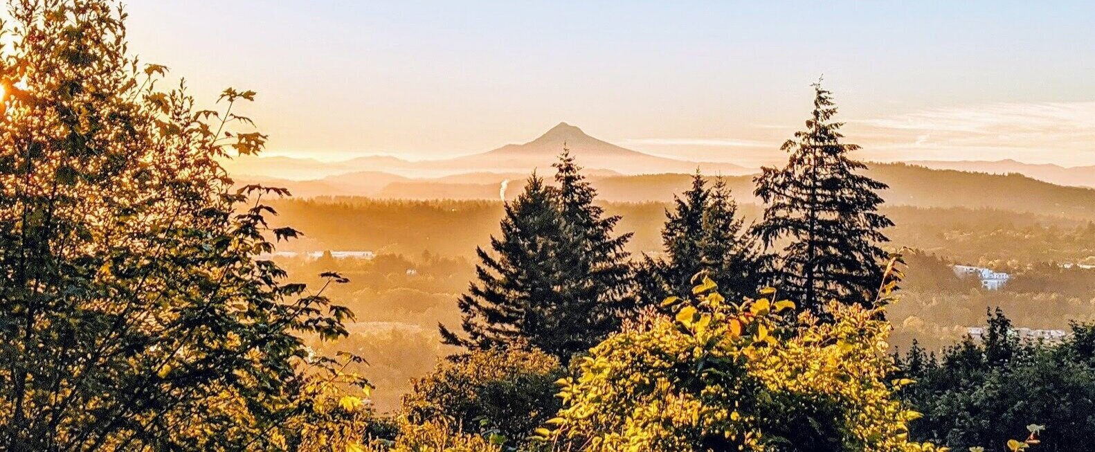
The mansion sits atop the West Hills, its lawn overlooking Portland with undoubtedly the best panoramic view in the city, with the snow peak of Mount Hood straight ahead in the far distance. Come here for the sunrise on a clear morning, it will blow you away.
Tip for runners: Burnside St right under the hill isn't accessible to pedestrians (even though Google Maps says so), so the usual way to get here is through Wildwood trail. It's about 3 miles with 900ft elevation gain from the nearest trailheads: Lower Macleay Park from the north, or Washington Park entrance on Burnside St from the south.

Hoyt Arboretum
Occupying the entire western part of Washington Park, the 190-acre Hoyt Arboretum is home to 2,300 species of trees and shrubs from all over the world. 12 miles of trails intertwines in the arboretum, including the Wildwood trail that starts in the arboretum and stretches 30+ miles north deep into Forest Park.
A great place to appreciate the handsome redwood trees is the redwood observation deck located on Wildwood trail at the north end of the arboretum and Washington Park.
Tip for runners: Check out Hoyt Arboretum trail map here. In case you want to start or end your run in the arboretum, there is an MAX light rail station nearby with trains going to and from downtown.

International Rose Test Garden
Portland's International Rose Test Garden is the oldest continuously operating public rose test garden in the country. Now it has over 10,000 rose bushes of approximately 650 varieties.
Portland's amicable relationship with roses dates all the way back to 1888, when Georgiana Burton Pittock (yup it's her again) invited her friends to show their roses in her garden. The next year, she founded the Portland Rose Society and Portland' started to be referred as the "City of Roses". However, it was not until 2003 that Portland adopted it as its official nickname.
Tip for runners: International Rose Test Garden is open and free to the public whenever Washington Park is open (5am-10pm). The Japanese Garden next door charges an admission fee.

Vietnam Veterans of Oregon Memorial
Located in the southwest corner of Hoyt Arboretum and Washington Park, this memorial is dedicated to the 57,000 Oregonians who served in the Vietnam War. A path started from the center of the Garden of Solace and spirals up a small hill, with black granite monuments spaced along the path listing Oregon soldiers perished during each year of the war.
Tip for runners: Instead of running, walk in the memorial.

Witch's Castle
Witch's Castle is what local folks call the stone house ruins on Wildwood trail, by the Balch Creek between lower and upper Macleay trails. The stone house has lived a few lives before and after it was abandoned as a public toilet and is now a popular photography spot hidden in the Forest Park, famous for its lush green moss and colorful graffiti.
Tip for runners: Lower Macleay trail meets Wildwood trail here. Lower Macleay Park is of the two most convenient access points to Forest Park from Northwest District, the other one is Forest Park Northwest Entrance at the end of NW Thurman St.

Vista Bridge
Portland has twelve bridges over the Willamette River, some are great beauties themselves (like St. Johns Bridge). Nevertheless, in my opinion, none of them has a better view than that of Vista Bridge, an overpass just outside Portland downtown. I guess the bridge and street are called “Vista" for a reason.
Tip for runners: Don't stop just yet. Keep going up on Vista Ave and there is another fantastic vista point right around the turn of the road before SW Carter Ln.

Council Crest Park
At 1,071 ft (326m) elevation, Council Crest Park is the highest point of Portland. One hundred years ago, an amusement park operated at the hilltop and was served by a streetcar line from downtown. Neither the amusement park nor the street car line survived, only the views remain. From here it is possible to see Mount Rainier, Mount St. Helens, Mount Adams, Mount Hood in the Cascade Range.

Terwilliger Blvd View Points
Terwilliger (pronounced with a hard g as in go) Blvd is a parkway between downtown Portland and Lake Oswego, meandering in parallel to the Willamette River on the hillside. The segment between Duniway Park and Interstate 5 intersection has a popular multi-use path for walkers, runners and cyclists. While this segment is mostly covered by trees, several openings and turnouts offer great views from the boulevard.
Take the climb above Duniway Lila Garden, the first bend o.2 mile up the hill has a nice, though somewhat blocked view of Portland downtown.
The view opens up at the curve between SW Bancroft St and SW Hamiltion Park. Visible from this segment are Willamette River, Sellwood Bridge, and on a clear day, Mount Hood .
My favorite view point is the tiny park with a totem at the north corner of the parking lot of Chart House restaurant. Come here just after sunrise and be ready to be amazed.
Tip for runners: Terwilliger Blvd is the best running route to connect Portland with Lake Oswego as well as Oregon City from the west side. Outside Tryon Creek State Natural Area, parkway shoulders narrow or disappear therefore the road becomes unsuitable for running. A parallel trail inside the park should be used instead.

Duniway Track
An excellent public track with eight lanes and state-of-the-art surface made from recycled rubber, including over 20,000 lbs. of athletic shoe soles donated by Nike. The track is usually available for drop-in use and when the track is permitted for practices, the outer lanes of the track are still available for drop in-use. At Duniway track, you will see local runners of all level. Rain or shine, there is good energy at Duniway track.
Marquam Park ?
George Himes City Park ?
Breakfast Ideas
JoLa Cafe
03.
Hawthorne to Mt. Tabor
Distance : 6 miles
Road Type : city streets and dirt trail
Profile : moderate (550 ft+)
Auto Traffic : medium
Start & Finish : Ladd's Addition, Hawthorne St and César Chávez Ave
Lorem ipsum dolor sit amet, consectetur adipiscing elit, sed do eiusmod tempor incididunt ut labore et dolore magna aliqua. Ut enim ad minim veniam, quis nostrud exercitation ullamco laboris nisi ut aliquip ex ea commodo consequat. Duis aute irure dolor in reprehenderit in voluptate velit esse cillum dolore eu fugiat nulla pariatur. Excepteur sint occaecat cupidatat non proident, sunt in culpa qui officia deserunt mollit anim id est laborum.

Things to See

Mt. Tabor Park
While Forest Park is a heaven for trail runners, Mt. Tabor park is my personal favorite, finding a sweet spot between the calm and beauty of nature and the convenience and excitement of urban life. Built on top of an extinct volcano in Southeast Portland, Mt. Tabor Park is home to three open-air reservoirs, various lawns and wooded spaces, a series of walking and running trails, and long flights of stairs. It also offers the best spot in the city for a sunset picnic in the park.
My favorite spots in the park are the lookout point in front of Reservoir 5 and the cabin in the wood near the east picnic area .
Tip for runners: Mt. Tabor Park Trail Map can be found on Friends of Mt. Tabor Park Website. An outer loop of the park is roughly 2 miles, with a modest elevation gain of 280ft (85m), definitely not a flat city park run. For more serious runners, a stretch of East Tabor Dr at the back of the park is perfect for hill repeats, and the long flights of stairs between SE 69th Ave entrance and the crest of the park ensure a fun stairs session.

Ladd's Addition
This charming neighborhood in southeast Portland not far from the Willamette is the city's oldest planned residential development, and one of the oldest in the western United States. Unlike the grid street plan pervasive in Portland, diagonal streets constitute the core of Ladd's Addition, with one circular rose garden in the center and four smaller diamond-shape ones two streets away in four directions.
Thanks to the American elms lining the narrow, quiet streets, Ladd's Addition is one of the best places to see fall foliage in Portland.

Art Fills The Void
This mural at SE 12th Ave & SE Division St is a restored version of Portland's oldest surviving community mural, painted in 1982 by a guerrilla art group with one of the greatest motifs of contemporary art: a banana.
Tip for runners: Running is an ideal way to see as much of public art as one can in a short period of time. If you are interested in mural art, here is a street art map from Portland Street Art Alliance, and check out recent works made through Forest For The Trees.

Hawthorne Blvd
More of a “Street" than a “Boulevard", Hawthorne is in my opinion the most Portland street of Portland. It's all about being local and being weird. The main commercial area between 30th Ave and 50th Ave features numerous local retail stores, from restaurants and bookstores to street food stands and second hand clothing stores. A run between the Hawthorne Bridge and Mt. Tabor Park is a perfect introduction to the sprawling east side of Portland.
Breakfast Ideas
Grand Central Bakery
Jam On Hawthorne
Fried Egg I'm In Love
The Waffle Window
Harlow
Albina Press
Tabor Bread
The Hazel Room
Upper Left Roasters
Neighborhoods
01.
North
Things to See
1. St. Johns Bridge & Cathedral Park
Lorem ipsum dolor sit amet, consectetur adipiscing elit, sed do eiusmod tempor incididunt ut labore et dolore magna aliqua. Ut enim ad minim veniam, quis nostrud exercitation ullamco laboris nisi ut aliquip ex ea commodo consequat. Duis aute irure dolor in reprehenderit in voluptate velit esse cillum dolore eu fugiat nulla pariatur. Excepteur sint occaecat cupidatat non proident, sunt in culpa qui officia deserunt mollit anim id est laborum.
2. St. Johns
Lorem ipsum dolor sit amet, consectetur adipiscing elit, sed do eiusmod tempor incididunt ut labore et dolore magna aliqua. Ut enim ad minim veniam, quis nostrud exercitation ullamco laboris nisi ut aliquip ex ea commodo consequat. Duis aute irure dolor in reprehenderit in voluptate velit esse cillum dolore eu fugiat nulla pariatur. Excepteur sint occaecat cupidatat non proident, sunt in culpa qui officia deserunt mollit anim id est laborum.
3. Overlook Park
Lorem ipsum dolor sit amet, consectetur adipiscing elit, sed do eiusmod tempor incididunt ut labore et dolore magna aliqua. Ut enim ad minim veniam, quis nostrud exercitation ullamco laboris nisi ut aliquip ex ea commodo consequat. Duis aute irure dolor in reprehenderit in voluptate velit esse cillum dolore eu fugiat nulla pariatur. Excepteur sint occaecat cupidatat non proident, sunt in culpa qui officia deserunt mollit anim id est laborum.
4. Adidas Headquarter
Lorem ipsum dolor sit amet, consectetur adipiscing elit, sed do eiusmod tempor incididunt ut labore et dolore magna aliqua. Ut enim ad minim veniam, quis nostrud exercitation ullamco laboris nisi ut aliquip ex ea commodo consequat. Duis aute irure dolor in reprehenderit in voluptate velit esse cillum dolore eu fugiat nulla pariatur. Excepteur sint occaecat cupidatat non proident, sunt in culpa qui officia deserunt mollit anim id est laborum.
5. Paul Bunyan Statue
Lorem ipsum dolor sit amet, consectetur adipiscing elit, sed do eiusmod tempor incididunt ut labore et dolore magna aliqua. Ut enim ad minim veniam, quis nostrud exercitation ullamco laboris nisi ut aliquip ex ea commodo consequat. Duis aute irure dolor in reprehenderit in voluptate velit esse cillum dolore eu fugiat nulla pariatur. Excepteur sint occaecat cupidatat non proident, sunt in culpa qui officia deserunt mollit anim id est laborum.
6. Pier Park & Chimney Park
On the east waterfront of the Willamette, a multi-use path runs from the Hawthorne Bridge to the Steel Bridge. Though not as spacious nor beautiful as the waterfront park it opposites, the esplanade offers a great view of Portland downtown and the waterfront park, and serves as a key corridor connecting runners and cyclists between northeast and southeast Portland.
7. Peninsula Park
Lorem ipsum dolor sit amet, consectetur adipiscing elit, sed do eiusmod tempor incididunt ut labore et dolore magna aliqua. Ut enim ad minim veniam, quis nostrud exercitation ullamco laboris nisi ut aliquip ex ea commodo consequat. Duis aute irure dolor in reprehenderit in voluptate velit esse cillum dolore eu fugiat nulla pariatur. Excepteur sint occaecat cupidatat non proident, sunt in culpa qui officia deserunt mollit anim id est laborum.
Mississippi
Breakfast Ideas
Sparrow Bakery
Two Stroke Coffee Co.
Chop St. Johns
Posies Bakery & Cafe
The Arbor Lodge
The Great North
Fried Egg
Albina Press
Blue Star
Gravy
Grand Central
Bernstein's
Jinju
Cathedral
02.
Northeast
Things to See
Alberta Art District
Powell Butte
Grant Track
Fernhill Track
Hoyt Arboretum
Redwood Observation Deck
International Rose Test Garden
Vietnam Veterans of Oregon Memorial
Witch's Castle
Vista Bridge
Council Crest Park
Terwilliger Blvd
Duniway Track
Breakfast Ideas
Seastar
Pround Mary / Petite Province / Fuel? / Barista / Case Study / Capitola?
KISS
Grand Central
Prince Pip's
Guilder
Saint Simon / Twisted / Woodblock
Doe / Bitter Rose
Case Study
Cameo
JoLa Cafe
Pine State Biscuits
Harlow
Good Coffee
The Clearing Cafe
St. Honoré Bakery
03.
Downtown / Northwest
Pioneer Square
Pearl District
23rd Ave
Powell's City of Books
South Park Blocks
Portland Art Museum
Lorem ipsum dolor sit amet, consectetur adipiscing elit, sed do eiusmod tempor incididunt ut labore et dolore magna aliqua. Ut enim ad minim veniam, quis nostrud exercitation ullamco laboris nisi ut aliquip ex ea commodo consequat. Duis aute irure dolor in reprehenderit in voluptate velit esse cillum dolore eu fugiat nulla pariatur. Excepteur sint occaecat cupidatat non proident, sunt in culpa qui officia deserunt mollit anim id est laborum.
Things to See
Mt. Tabor
Ladd's Addition
Art Fills The Void
Hawthorne St
Breakfast Ideas
Grand Central Bakery
Jam On Hawthorne
Fried Egg I'm In Love
Upper Left Roasters
The Waffle Window
Harlow
Albina Press
Tabor Bread
The Hazel Room
North
Northeast
Alberta Art District
Powell Butte
Grant Track
Fernhill Track
Northwest / Downtown
East
Laurelhurst Park
Buckman Track
Southeast
Oak Bottom Refuge
Reed College Parkway
Southwest
Tryon Natural Park
Lake Oswego
Foothills Park
Greater Portland Area
Springwater Corridor
Powell Butte
Gresham
Marine Dr / I-205
Vancouver Waterfront
Kelly Point
Trolley Trail
Milwaukie Bay Park
Oregon City
Clackamette Park
Willamette Falls Scenic Viewpoint
Sunset Highway Trail
Nike Headquarter