Make it stand out
San Francisco


Routes
1. Golden Gate Bridge

• Start & Finish: Fort Mason, Golden Gate Bridge North Vista Point
• Course Profile: 5.1 mile one way, 360 ft+, walking path (Strava)
Known for its stunning beauty and engineering marvel, the Golden Gate Bridge is one of the most famous bridges in the world. It stretches approximately 1.7 miles and stands at a height of 746 feet, and its distinctive International Orange color has become synonymous with the city of San Francisco.
This scenic route begins at the picturesque Fort Mason. As you continue running, you'll pass through Marina Green and Crissy Field, two popular, scenic waterfront green spaces, as well as the monumental Palace of Fine Arts. To reach the Golden Gate Bridge, take the short but steep climb off Old Mason St at Crissy Field Ave and follow the trail to the visitor center and vista point.
When crossing the bridge, pedestrians should always use the east-side sidewalk. Keep in mind that the bridge is often windy and foggy. On the opposite side of the bridge, the path ends at another vista point, providing the best view of the bridge against the city skyline. From there, a trail continues north to Sausalito, and an underpass allows access to trailheads for Hawk Hill and the Marin Headlands.
There are a few notable historic sites near the bridge. In the south, you'll find Fort Point, a fortification that gained fame for its appearance in Hitchcock's film Vertigo. In the north, Battery Spencer awaits with its breathtaking views, accessible via a short, steep hike.
More Routes
Cafe
Dynamo Donut + Coffee and Equator Coffee (on in Fort Mason, and one conveniently located in the Golden Gate Bridge Round House) are right on this route.
Chestnut Street in the Marina district is a trendy street with Le Marais Bakery. Further away there are Wrecking Ball Coffee and TCP's pick Saint Frank Coffee.
Fisherman's Wharf offers a wide array of dining choices, though they tend to be quite touristy.
Transit
Muni Bus Route 28 stops by the Golden Gate Bridge Visitor Center. Make sure that you board the correct bus, as both directions share the same stop.
Muni Bus Route 30 is a frequent service that connects Downtown San Francisco, Chinatown, North Beach, and Fort Mason.
2. Golden Gate Park

• Start & Finish: JFK Dr and Kezar Dr
• Course Profile: 7.3 mile loop, 313 ft+, walk path and road
One of the largest and most iconic city parks in the country, the 1017-acre Golden Gate Park is an urban oasis that spans over three miles long and 50 city blocks. The park features lush greenery, beautiful gardens, serene lakes, and meandering trails that invite exploration and relaxation.
Two main roads traverse Golden Gate Park: JFK Drive on the north and MLK Drive on the south. JFK Drive has been transformed into a permanently car-free street with art installations. MLK Drive remains open to cars but offers ample space with wide sidewalks and parallel trails for pedestrians and cyclists to enjoy. This loop route connects these two roads through the oceanfront Great Highway and Kezar Dr.
There are countless additional trails and paths to explore in the park. Here to name a few:
- Stow Lake and Strawberry Hill (p3): there is a loop around the lake and a spiral trail up the hill
- Polo Field: there is a gravel loop for running and an inner loop for cycling
- Kezar Stadium (p4): the city’s most popular public outdoor track
There are also numerous landmarks and attractions to check out in the park: the Conservatory of Flowers (cover), de Young Museum (p5), California Academy of Sciences, San Francisco Botanic Garden, Japanese Tea Garden (p7), Shakespeare Garden (p8), Rose Garden, Bison Paddock, two windmills and a tulip garden (p10).
More Routes
Continue with other recommended routes
- The Presidio (route 5)
- Ocean Beach & Lands End (route 6)
- Panhandle & Buena Vista (route 8)
- Mt. Sutro (route 13)
- Sunset (route 14)
Cafe
Balboa St and Irving St are the two business corridors along Golden Gate Park. On the southeast corner of the park, Cole Valley / Haight Ashbury is another lively area packed with cafes and shops.
Transit
Muni Bus Route 5 runs frequently along the northern border of the park, the Metro N Line is located just two blocks south of the park. Many other bus lines serve the neighboring areas as well
3. Twin Peaks

• Start & Finish: 17th St & Clarendon St, Twin Peaks Blvd & Portola Dr
• Course Profile: 2.1 mile, 381 ft+, road
Twin Peaks are two prominent hills located in the geographic center of the city. Standing at about 900ft (280m), They are known for the breathtaking panoramic views of the surrounding area, including the city skyline, Golden Gate Bridge, and the Pacific Ocean. Micro-climate around Twin Peaks can be volatile and often foggy during the summer.
The Twin Peaks climb stands out as one of the most challenging, yet immensely rewarding, routes for running in San Francisco. This route follows Twin Peak Blvd southward and you'll be greeted by ever-improving views all the way to the hilltop vista point. Twin Peaks are the two hills just south of the vista point. Some choose to run around the peaks, while many opt to explore the peaks through stairs dirt trails (p5-6).
If you start from Castro St Metro Station, the uphill adventure features a gnarly climb (p7) on 17th St that is even more demanding than the actual summit ascent. Once you are on top, there are several options for finishing or extending your run.
- Retrace your steps back down
- Continue south on Twin Peaks Blvd or dirt trails and turn on Portola Dr to take Upper Market St (p8) back to the Castro.
- For longer runs, Mt. Sutro (route 13) and Glen Canyon Park (route 12) are two wonderful urban trail areas immediately adjacent to Twin Peaks.
More Routes
Continue with other recommended routes
- Golden Gate Park (route 2)
- Panhandle & Buena Vista (route 8)
- Market Street (route 9)
- Mission (route 11)
Cafe
Cole Valley in the north and Noe Valley in east are two neighborhoods that one can find cafes and restaurants.
Transit
Muni Metros go under or around Twin Peaks, with stations at Castro (K, L, M Line ), Carl St (N Line) and Forest Hill (K, M Line). A few infrequent bus lines serves the neighborhoods around Twin Peaks, including route 33, 37, 48, 52.
4. The Embarcadero

• Start & Finish: Oracle Park & Aquatic Park
• Course Profile: 3.8 mile one way, flat, waterfront promenade
The Embarcadero is a popular waterfront area that stretches along the eastern shoreline of the city with a wide promenade, offering visitors a chance to explore some of the city's most iconic landmarks. From south to north, some of the notable landmarks include:
Oracle Park (p3): This baseball stadium is home to the San Francisco Giants and is located right on the waterfront. Visitors can walk along the path behind the stadium and discover plaques and statues commemorating the team's successes.
Bay Bridge (p5): The San Francisco-Oakland Bay Bridge connects the cities of San Francisco and Oakland via Treasure Island. The western span of the bridge is a suspension bridge with towers and can be seen from the Embarcadero.
Ferry Building (p6): This historic landmark is the primary transportation hub for commuters arriving in San Francisco by ferry. It also houses a vibrant marketplace with eateries and artisanal shops, and a popular farmers market on some days.
Pier 39 (p8): Located in the waterfront Fisherman's Wharf neighborhood, it is one of San Francisco's most popular tourist destinations, featuring seafood restaurants, souvenir shops, and scenic views.
Aquatic Park (p9): The park features a small beach with swimming area. A short walk away is Ghirardelli Square (p10), a historic shopping and dining complex located in the former home of the famous Ghirardelli chocolate factory.
More Routes
Continue with other recommended routes
- Golden Gate Bridge (route 1)
- The Presidio (route 5)
- Market Street (route 9)
- Mission Bay (route 10)
Cafe
Cafes and restaurants along the route concentrate in Fisherman's Wharf, Ferry Building, and near the ballpark.
Transit
Embarcadero is a station by the ferry building, served by BART and many Muni trains. Muni K line goes south from there and Streetcar F line goes north.
5. The Presidio

• Start & Finish: Arguello St at Pacific Ave
• Course Profile: 5.6 mile loop, 480 ft+ flat, trails and sidewalks
This route follows mostly Washington Blvd and Lincoln Blvd; for alternative routes, consider other trails in the park: Park Trail, Mountain Lake Trail, Lobos Valley Trail, Ecology Trail, and Battery to Bluffs Trail.
The Presidio is a 1,500-acre park located at the northern tip of San Francisco. Originally built by the Spanish in 1776 as a military outpost, it later served as a military base for the US Army. Today, it is a popular city park featuring many wooded areas, trails, bikeways, and overlooks.
On the west side, visitors can enjoy scenic bluffs and sandy beaches (Baker Beach and Marshall's Beach, cover & p3-4) with stunning views. At the north tip of the Presidio, several former battery sites can be found, as well as the Golden Gate Bridge welcome center and overlook.
The presidio is home to San Francisco National Cemetery (p5), not far from the Main Post, the heart of the Presidio and the center of the visitor experience.
On the east side, one will discover some off the beaten path attractions, including Lucas Film campus (p6), Lyon Street Steps (p7), as well as Andy Goldsworthy's Wood Line (p8). Just outside the northeast corner of the Presidio is one of San Francisco's most iconic landmarks, the Beaux-Arts style Palace of Fine Arts (p9).
More Routes
Continue with other recommended routes
- Golden Gate Bridge (route 1)
- Golden Gate Park (route 2)
- The Embarcadero (route 4)
- Ocean Beach & Lands End (route 6)
Cafe
Cafes and coffee shops are scatted around different neighborhoods surrounding the park, usually several blocks away from the park limit.
Transit
The Presidio is served by Muni bus route 28, 29, 43, and 45. For direct bus to/from downtown, take route 1 on California St.
6. Ocean Beach
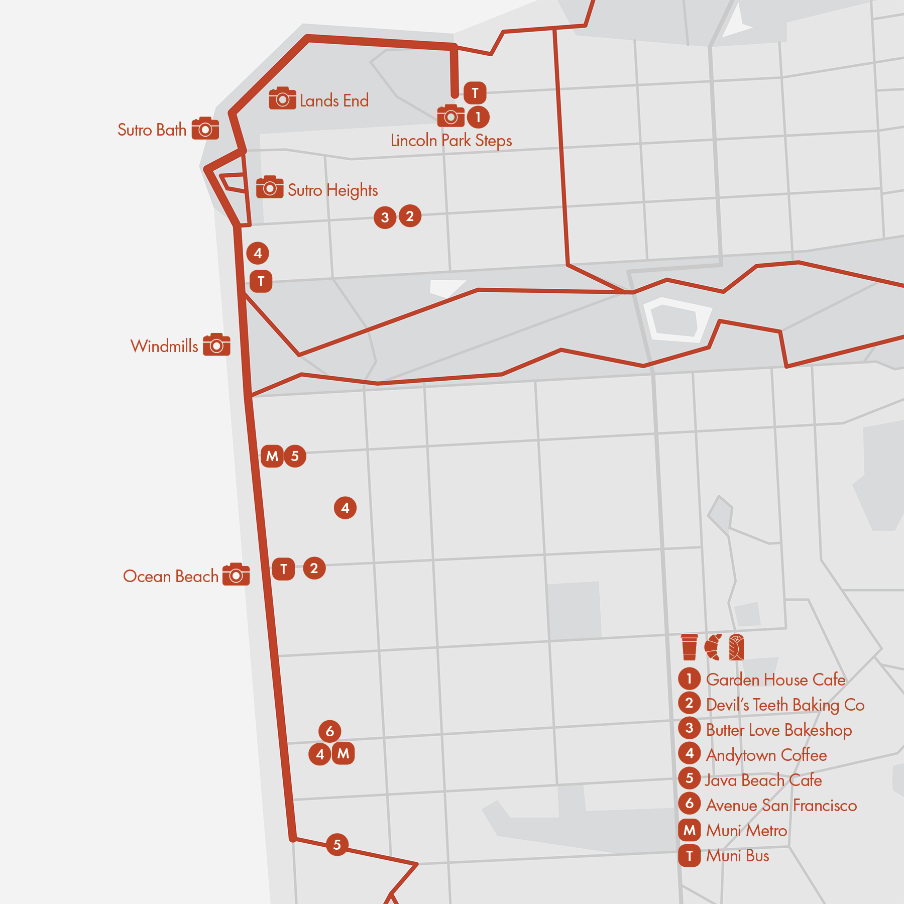
• Start & Finish: Cliff House (1) south to Sloat Blvd (2) north to Lincoln Park Steps
• Course Profile 1: 3 mile one way, flat, separated path
• Course Profile 2: 1.9 mile one way, 260ft+, trail
Ocean Beach (cover, p3-4) is a long stretch of sandy beach along the Pacific Ocean on the western edge of San Francisco. Despite its notorious strong currents and heavy fog, it remains a popular site for local runners and cyclists who use the car-free (on weekends and holidays) Great Highway along the beach.
Ocean Beach is located at the western end of Golden Gate Park, marked by two windmills (p5) on the corners of the park. Further north is the historic Cliff House restaurant, situated on the cliffs above the ocean, is a popular destination and marks the end of the beach.
Sutro Heights Park (p6), located adjacent to the Cliff House, is a charming elevated park that offers panoramic views of the ocean and the city. The park is named after Adolph Sutro, a wealthy businessman and former mayor of San Francisco, left a lasting legacy throughout the city. The ruins of Sutro Baths (p7), which were once the largest indoor swimming complex in the world, are located nearby and offer a glimpse into San Francisco's past.
Adjacent to Sutro Baths is Lands End, a scenic park featuring rugged trails along the coastal cliffs that offer stunning views of the Golden Gate Bridge and Marin Headlands (p8-9). At the east end of the trail lies Lincoln Park, home to the Legion of Honor, a fine art museum, and the Lincoln Park Steps (p10), one of the many hidden mosaic staircases in the city.
More Routes
Continue with other recommended routes
- Golden Gate Park (route 2)
- The Presidio (route 5)
- Sunset District (route 14)
- Lake Merced (route 15)
Ocean Beach borders the residential neighborhoods of Outer Richmond and Outer Sunset. Most local businesses concentrate on Balboa St, Judah St, Noriega St, and Taravel St.
Cafe
Transit
Muni Metro Line N-Judah and L-Taraval end by Ocean Beach. Muni Bus Lines 5R, 7, 18, 23, 31, and 38 also serve Ocean Beach.
7. The Hills

• Start & Finish: Columbus Ave at Lombard St; Coit Tower
• Course Profile: 3.5 mile one way loop, 790ft+, sidewalk
Many cities are hilly, none other is like San Francisco. This sightseeing route goes through a few iconic hills (Nob Hill, Russian Hill, Telegraph Hill) in central San Francisco, and passes numerous landmarks and parks.
- North Beach/Little Italy is a vibrant neighborhood, historically home to many Italian immigrants. It has long been a hub for artists and writers (check out City Lights Bookstore), and nowadays also known for its nightlife scene. It is home to Washington Square (p3), a central gathering spot for locals and visitors alike.
- San Francisco's Chinatown (p4) is one of the largest and oldest Chinatowns outside of Asia. It is centered around Grant Ave, with the Dragon Gate at its south end on Bush St.
- The Transamerica Pyramid (p5) has been a highlight of San Francisco's skyline since 1972 and was the tallest building in the city until 2018.
- Don't miss the view at the top of California Ave (at Mason St, p6), the spectacular view represents the unique urban beauty of San Francisco.
- Ina Coolbrith Park (cover, p7) is a hidden gem situated on top of a hill, providing stunning views of the city skyline.
- Lombard Street (p8) is often referred to as the "crookedest street in the world." The steep, winding section between Hyde St and Leavenworth St features eight sharp turns and attracts tourists from all over the world.
- Down the Russian Hill is San Francisco's newest Francisco Park (p9), it has great views of the bay.
- Standing atop Telegraph Hill, Coit Tower (p10) provides panoramic views of the city and the bay from its observation deck.
More Routes
Continue with other recommended routes
- Embarcadero (route 3)
- Market St (route 9)
This is one of the most lively and touristy areas of San Francisco. Restaurants and cafes are everywhere, especially in North Beach, Chinatown, Nob Hill and along Polk Street.
Cafe
Transit
This area is served by central subway Line T, and frequent bus services including 1, 8, 30, 45.
8. The Panhandle

Buena Vista Park Loop
• Course Profile: 1.0 mile loop, 200 ft+, sidewalk
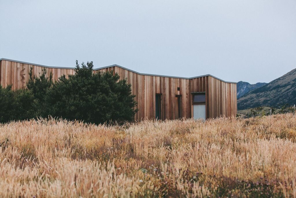
Established in 1867, Buena Vista Park (p3-4) is the city's oldest and third-largest park. With steep terrain and a peak at 575 feet, the park offers excellent views and features several urban hiking trails. Some houses along the periphery of the park are notable for their modern architecture.
Panhandle Loop
• Course Profile: 1.5 mile loop, flat,, sidewalk
The Panhandle (p5-6) is a long, one-block wide park that stretches from Golden Gate Park to the Haight-Ashbury neighborhood. It is lined with trees, benches, and grassy areas.
Corona Heights
• Course Profile: 0.33 mile one way, 160 ft+, dirt trail
Corona Heights Park (cover, p7) is a small hilly park. Its rocky peak has the bedrock in terra cotta red and offers amazing panoramic views of the city, including downtown, Twin Peaks, and the Golden Gate Bridge.
Other places to check out
Alamo Square (p8-9) is a city park known for the iconic Painted Ladies, a row of Victorian houses, which sit across on the east side with the San Francisco skyline in the background. Built in the 1890's, these houses represent the unique architectural style and colorful facades during the Victorian era.
Haight-Ashbury (p10) is a neighborhood named after the two crossing streets. It was the center of SF's counterculture movement in the 1960s, reaching its peak during the 1967 "Summer of Love''. Today the neighborhood is still one of the hippest in the city.
More Routes
Continue with other recommended routes
- Twin Peaks (route 4)
- Market St (route 9)
- Mission (route 11)
- Mt. Sutro (route 14)
Cafe
Great restaurants and cafes are scattered around this area, from Cole Valley to Lower Haight to Duboce Triangle and The Castro.
Transit
Muni Metro L, M, and K Lines meet at Castro Station, southeast of Corona Heights; N Line goes under Buena Vista Park with stations on both sides of the tunnel. Due to the hilly terrain, this area doesn't have many frequent bus services besides Bus 6, 7 on Haight St and Bus 24 on Divisadero St.
9. Market St

• Start & Finish: Ferry Building & The Castro
• Course Profile: 3.2 mile one way, 180 ft+, sidewalk (Strava in bio)
Market Street, a major thoroughfare in San Francisco, was laid out originally in 1847 and is still the center of the city's business, shopping, and entertainment.
With numerous intersections, Market St is best for a relaxing jog or sightseeing run. Also note that Mid-Market (between 5th St and 10th St) is a bit rough, especially if you are new to the city.
There are a series of San Francisco landmarks along or near Market St.
- Ferry Building (cover, p3) was completed in 1898 and still serves as a ferry terminal while housing a marketplace inside.
- Stretching four city blocks, Sales Force Park (p4) is an elevated urban garden at the base of the tallest building in the city.
- SFMOMA (p5) is one of the largest and best museums of modern and contemporary art in the United States.
- Union Square (p6) is SF's top shopping destination.
- Despite the constant homelessness issue in its surrondings, SF City Hall (p7) is still worth a quick look.
- The Castro (p9) is one of the first gay neighborhoods in the US and remains a vibrant social and cultural center for the LGBTQ+ community.
Muni Line F is the only remaining historic streetcar (p10) in San Francsico and it runs along Market St. You can also catch a glimpse of the world famous cable car at its turn-around point at Powell St/Market St.
More Routes
Continue with other recommended routes
- Embarcadero (Route 3)
- Twin Peaks (Route 4)
- Russian Hill (Route 7)
- Panhandle & Buena Vista (route 8)
- Mission Bay (Route 10)
- Mission (route 11)
Cafe
Although Market St is a bustling street, it's not typically known for its food and drink offerings. For a great market, the Ferry Building is a great destination. For more diverse options, exploring neighborhoods like Hayes Valley, the Mission, and the Castro.
Transit
Market St is a major transportation hub in San Francisco, with easy access to all Muni Metro lines, BART, and numerous Muni bus lines.
10. Mission Bay

• Start & Finish: Oracle Park & Heron's Head Park
• Course Profile: 3.6 mile one way, mostly flat, paved path (Strava in bio)
Part of this route is Mile 24 of the San Francisco Marathon.
Mission Bay and the neighboring Dogpatch are two of the most recently developed neighborhoods in San Francisco. This area was previously an industrial zone but has been transformed into a mix of residential, commercial, and office spaces, many of which were converted from old warehouses and factories.
Mission Bay is known for being home to two of San Francisco's most prominent sports venues. The Chase Center (cover) is the home arena for the Golden State Warriors, the reigning NBA champions. A few blocks north lies Oracle Park (p3-4), formally known as AT&T Park, which is the home of the MLB team San Francisco Giants. Both teams have won multiple championships in the past decade, making them beloved by many local residents.
At the end of this route lies Heron's Head Park (p9-10), a beautiful urban park with winding trails that meander through restored wetlands and upland areas. The park offers stunning views of the San Francisco Bay at its tip, making it a popular spot for nature walks and birdwatching.
Continue with other recommended routes
- Embarcadero (Route 3)
- Mission & Beyond (Route 11)
- Enjoy the green space in Bay Front Park and Crane Cove Park (p7)
- Explore the many hills of the Potrero Hill neighborhood.
More Routes
Cafe
There are an array of coffee shops and cafes located along the main thoroughfare of this area, 3rd St, as well as on the hilltop of 18th St at Missouri St.
Transit
The Muni T line runs along 3rd St (p8), providing easy access to SOMA and Chinatown.
The north end of this route is San Francisco's 4th & King Station, the terminus for regional rail service Caltrain.
Several Muni buses (19, 22, 48, 55) also serve the area, providing connections to SOMA/Downtown in the north and Potrero Hill/Mission in the west.
11. Mission

The Mission District is a very walkable neighborhood. For easy jogs, check out Folsom St and Valencia St; for hilly runs, take Dolores St (P3) or Castro St (P4). Below is a short, scenic run in Bernal Heights, just south of Mission.
• Start & Finish: Bernal Heights Park Parking Lot
• Course Profile: 1.2 mile loop, 177 ft+, paved path, dirt trail (Strava in bio)
The Mission District is one of San Francisco's oldest neighborhoods, dating back to the late 1700s when it was founded as a Spanish mission. The vibrant and diverse neighborhood has a rich history as the heart of the city's Latino community.
Valencia Street and Mission Street are two major thoroughfares one block apart. Valencia St (P5) is known for its trendy boutiques, coffee shops, restaurants, and bars; whereas Mission St (P6) is a bustling commercial corridor with a mix of small businesses and ethnic restaurants. Mission District is also known for its abundance of murals, reflecting the neighborhood's history, culture, and politics. In particular, check out Clarion Alley (cover).
Misión San Francisco de Asís is the oldest surviving structure in San Francisco; next door is the basilica (P7) and nearby is Mission Dolores Park (P8), one of San Francisco's most beloved parks and a popular gathering spot for locals to enjoy stunning views of the city skyline.
Bernal Heights is a hillside neighborhood just south of the Mission. Bernal Heights Park (P9-10) sits on the top of the hill and offers panoramic views of the city and the Bay.
More Routes
Continue with other recommended routes
- Market St (Route 8)
- Mission Bay (Route 10)
- Glen Canyon (Route 12)
- McLaren Park (Route 16)
Cafe
The Mission District is a foodie's paradise, home to some of the city's best coffee shops, bakeries, cafes, and taquerias.
Transit
The Mission District is easily accessible by public transportation, with several BART lines run under Mission St and Muni J train along Church St. Muni bus lines include frequent service 14, 49, and many more.
12. Glen Canyon

• Start & Finish: Portola Dr at Glenview Dr
• Course Profile: 2 miles loop, 420 ft+, dirt trails and some stairs (Strava in bio)
Glen Canyon is a natural park (cover, P3-6) located south of Twin Peaks, boasting a deep, forested canyon, a creek running through it, hiking trails, and unique rock formations. The 2-mile lollipop loop begins at the trailhead on Portola Drive and takes you on a long, narrow loop through the canyon. There are additional trailheads at Glen Park Rec Center and George Christopher Playground.
O'Shaughnessy Boulevard offers an impressive view of Glen Canyon from the west, with a wide paved sidewalk shared with cyclists. On the opposite side of the boulevard lies Mt. Davidson, the highest point in San Francisco, towering at 928 feet. Its summit offers breathtaking 360-degree views of the city and the surrounding Bay Area, it is also home to a tall, concrete cross (P7)
To the east of Glen Canyon, Billy Goat Hill / Walter Haas Playground (P8-9) is a small park that offers panoramic views of the city. The hill is accessible via a trail and flights of stairs, making the climb a rewarding experience. Other spots worth exploring in the area include Douglass Playground (great views) and Miraloma Steps (Dragon Tale Staircase, P10).
More Routes
Continue with other recommended routes
- Twin Peaks (Route 4)
- Mission & Bernal Heights (Route 11)
- Mt. Sutro & Beyond (Route 13)
Cafe
Noe Valley, located close to Glen Canyon, is a charming neighborhood with a variety of coffee shops and cafes. Among them, Neighbor's Corner and Viva La Tarte are two of my favorites in the city, offering delicious pastries and coffee. Additionally, there are several coffee shops located near the Glen Park BART station, making it a convenient spot to grab a cup of coffee before heading out on an adventure.
Transit
Glen Park is a major transit hub for the area, providing access to all BART lines in San Francisco and Muni Train J. In terms of bus routes, the Glen Canyon area is served by several Muni buses, including the 44, 48, and 52 lines.
13. Mt. Sutro

• Start & Finish: Stanyan St at 17th St
• Course Profile: 3 miles loop, 624 ft+, dirt trails and city streets (Strava in bio)
Mount Sutro is a small mountain located in the heart of San Francisco, one of the many places in San Francisco named after Adolph Sutro, a wealthy entrepreneur and former mayor of San Francisco. The area is covered by a dense urban forest (P3, P4), mostly eucalyptus trees, and is a peaceful and serene retreat for runners looking to escape the hustle and bustle of the city.
South of Mt. Sutro, Laguna Honda (P5) is another tranquil, hilly area with great running trails tucked away behind the Laguna Honda Hospital. Some of the trails are popular among mountain bikers and not well marked, so caution is advised.
Located west of Mt. Sutro, the Inner Sunset neighborhood is home to Grandview Park (P6, P7). Aptly named, the hilltop viewpoint offers sweeping 180-degree views of the city's north side, rivaled only by those from Twin Peaks. Nearby you'll find the iconic 16th Ave Steps (cover), the most famous stairway in this hilly neighborhood (P8, P9). The 163-step staircase features colorful mosaic tiles that form a stunning sea-to-stars design.
More Routes
Continue with other recommended routes
- Golden Gate Park (Route 2)
- Twin Peaks (Route 4)
- Haight-Hayes (Route 10)
- Glen Canyon (Route 12)
Cafe
If you are in search of good breakfast, you might need to venture to the flatter parts of the city as the hilly neighborhoods have limited options.
- Inner Sunset's hub, Irving St around 9th Ave, is a great spot to check out for bakeries and coffee shops.
- Alternatively, Cole Valley is another neighborhood with a multitude of food options, and there are even more options further north along Haight St.
Transit
Forest Hill and West Portal are two Metro train stations that are shared by lines L, M, and K, located on the southwest side of Mt. Sutro. Line N runs along the north side of the mountain. While several Muni buses also serve this area, their headways tend to be longer.
14. Sunset

• Start & Finish: Sunset Blvd at Golden Gate Park and Lake Merced
• Course Profile: 2.5 miles one way, mostly flat, sidewalks (Strava in bio)
The Sunset District is a large, residential neighborhood in southwest San Francisco. From tranquil streets to Sunset Blvd, there's something for everyone. Characterized by an almost perfect grid layout, the neighborhood's avenues are numbered and streets named alphabetically, making it easy to navigate and an ideal location for a relaxing run. Be aware of the mild and often foggy climate and dress in layers.
Sunset Blvd is a highlight of the neighborhood, spanning an entire city block between 36th and 37th Ave. The street boasts greenbelts and walking trails on both sides (P3) and stretches across the Sunset District, connecting the Golden Gate Bridge to the north with Lake Merced in the south.
Another great running spot is Sunset Reservoir (cover, P6), featuring a loop path that run just short of 1 mile and has an elevation gain of about 100 ft. The high ground offers spectacular views of Golden Gate Park to the north and the Pacific Ocean to the west.
More Routes
Continue with other recommended routes
- Golden Gate Park (Route 2)
- Great Highway / Ocean Beach (Route 7)
- Mt. Sutro (Route 13)
- Lake Merced (Route 15)
Cafe
The Sunset District is a low-key neighborhood that holds some of the city's hidden gems. Irving St and Taraval St are popular spots for local cafes and restaurants. Here are some of my top picks:
- Devil's Teeth Bakery: breakfast sandwiches;
- Pineapple King Bakery: soft and fluffy pineapple buns filled with various delicious paste;
- Not Latte: unusual flavors like Durian or Avocado Latte
- Rolling Out Cafe: mini croissants
- Avenue SF: coffee and musubi
Transit
East - West: Muni N and L train runs along Judah St and Taraval St, while Bus 7 serves Noriega St in the middle.
North-South: Bus 28 and 29 run along 19th Ave and Sunset Blvd.
There are other Muni buses that serve this area.
15. Lake Merced

• Start & Finish: Juan Bautista de Anza Statue (P3)
• Course Profile: 4.5 miles loop, mostly flat, multi-use path/sidewalks (Strava in bio)
Lake Merced is situated in the southwest corner of San Francisco, it is one of the three and the largest remaining natural freshwater lakes in San Francisco. This 4.5 mile loop on paved paths circles around the lake, it is mostly flat and has just one traffic intersection, hence a great running route for any thing between a recovery jog to a tempo run, or hit the loop multiple times for a long one!
- Fort Funston (P9, 10): the former fort features the last remnants of a sand dune ecosystem that once covered the western half of San Francisco (including where Golden Gate Park is today).
- Stern Grove: the big green space is home to Stern Grove Festival, a series of free summer concerts first held in 1938.
More Routes
Continue with other recommended routes
- Fort Funston has a few scenic trails, he main trailhead is at the intersection of Skyline Blvd at John Muir Dr.
- Connect with Great Highway / Ocean Beach (Route 7)
- Connect with Sunset Blvd (Route 14)
Cafe
There aren't a lot of cafes in this area. You can find some in SFSU and Stonestown Galleria, with more and better options scattered along Taraval St.
Transit
Catch Muni L train at SF Zoo, Muni M train / Bus 28 on 19th Ave, or Muni Bus 29 on Sunset Blvd.
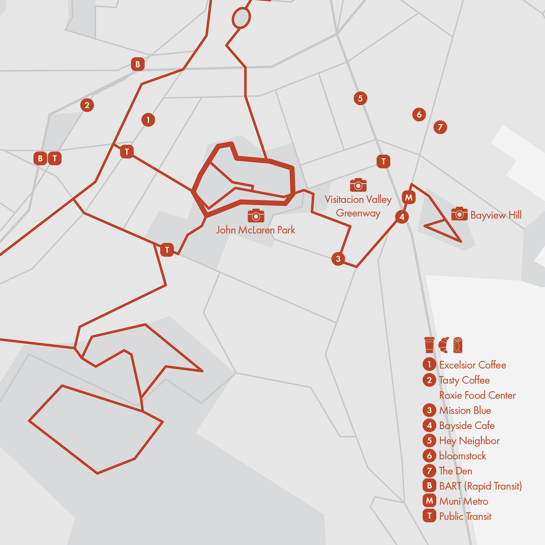
16. John McLaren Park
• Start & Finish: Philosopher's Way Trailhead
• Course Profile: 2.3 miles loop, 340 ft+, trail (Strava in bio)
In a city that is known for its urban beauty, John McLaren Park, the third largest park in San Francisco after Golden Gate Park and the Presidio, is overshadowed by smaller parks closer to the city center. But if you are willing to venture out to this part of the city, you'll for sure have a relaxing time in the woods. This 2.3-mile loop follows various trails along John F. Shelley Dr in the north and Coyote Trail in the south. Great city views can be found from Mansell Heights (cover, P7) as well as The Blue Water Tower (P4, 5)
More Routes
Continue with other recommended routes
- Visitacion Valley Greenway (P9) is a lovely path between Tioga Ave and Leland Ave, consisting of six narrow gardens, each traversing one city block.
- Bayview Hill (P10) on the other side of Hwy 101 has a nice trail loop (1.4 miles, 320 ft+, lollipop loop from 3rd St) with sweeping city views.
- Use S. Hill Blvd to connect with San Bruno Mountain (Route 17)
Cafe
The less visited neighborhoods of Excelsior, Portola, and Bayview have some of the hidden gems of coffee shops in San Francisco:
- Excelsior Coffee: motorcycle-themed neighborhood cafe.
- Mission Blue: lovely cafe that also sells crafts from local artists.
- Hey Neighbor: stylish, sunny shop with a community garden.
- Bloomstock: hole-in-the-wall shop with parklet stand seatings and delicious waffles.
Transit
Balboa Park is a transit hub with access to BART, Muni Metro and buses. Muni T train runs along 3rd St in the Bayview neighborhood.
Frequent Muni bus services include Bus 14 on Mission St and Bus 8, 9 on San Bruno Ave, both with a 10-minute headway.
17. San Bruno Mountain

• Start & Finish: Crocker Gate Trailhead
• Course Profile: 6.5 miles loop, 1000 ft+, trail (Strava in bio)
Marin Headlands are wonderful, but they are a bit far for runners from the southern side of the city. Local hills like Twin Peaks and Bernal Hill are great for a short hill run on paved roads, but if you are looking for longer, soft surface trails, San Bruno Mountain is there for you.
This trail running route consists of two loops: first the moderate Saddle Loop (2.65 miles, 255ft+) in the north, then the more strenuous Summit Loop (3.6 miles, 730 ft+, P4) in the south. Two loops are connected by a short path under Guadalupe Canyon Pkwy. The main trail head (P3) is off Saddle Loop at Crocker Ave at S. Hill Blvd. The main entrance/parking is between two loops.
San Bruno Mountain isn't known for its views. The most scenic spots are along the higher grounds of Summit Loop and Ridge Trail.
- Cayuga Park (P9-10): a small neighborhood park curated by an SFP&R employee with figurines, totem poles and statues.
More Routes
Continue with other recommended routes
• Alternative routes
To make the run longer, you can add a 5-mile, 800 ft+ out-and-back detour on Ridge Trail (P5-7) , or take Ridge Trail all the way and descend to Firth Canyon (P8) / Brisbane to make this a point to point run.
* Connect with more routes
- Use John Daly Blvd to connect with Lake Merced (Route 15)
- Use S. Hill Blvd to connect with John McLaren Park (Route 16)
Cafe
Mission St is where local businesses, cafes and restaurants concentrate on.
Transit
- Balboa Park is a transit hub with access to BART, Muni Metro and buses.
-;Frequent Muni bus services include Bus 14 on Mission St and Bus 8 on Geneva Ave, both with a 10-minute headway.
18. Marin: Hawk Hill

• Start & Finish: GGB headlands parking lot
• Course Profile: 1.85 miles one way uphill, 570 ft+, roadside trail (Strava in bio)
This short, steep route from GGB to Hawk Hill is the most scenic and accessible route in Marin Headlands for runners and cyclists alike. Just follow Conzelman Rd.
From the top of the hill, going back down is a fast, fun downhill. If you decide to continue west, the immediate section has 18% grade (P7) hence it is one way only (to go down). Stay to the side and watch out for bikes and occasional traffic. The shortest detour to loop back adds ~2 miles and 460 ft+. If you are not in a hurry to get back, go all the way to Point Bonita Lighthouse and Rodeo Beach, which add about 6 miles and 800 ft+ for a loop.
- Battery Spencer (cover): the proximity and juxtaposition to Golden Gate Bridge make this the most spectacular, almost intimidating view.
- Hawk Hill (P4-P6): the view has both Golden Gate Bridge and Bay Bridge with San Francisco Skyline in between, and the rest of the frame filled by the San Francisco Bay and Marin Headlands. The hilltop is a small mount above the parking lot, with the remnant of Nike Missile Control Site.
- Point Bonita Lighthouse (P9): the lighthouse had the first fog signal on the West Coast and the last manned lighthouse on the California coast.
- Rodeo Beach (P10): A barrier beach between the Pacific Ocean and Rodeo Lagoon.
More Routes
Continue with other recommended routes
- Use the underpass to cross Golden Gate Bridge and run back to SF (Route 1) or follow Alexander Ave to Sausalito (Route 20)
- Connect with Ninja Loop (Route 19) via various trailheads
Cafe
Coffee shops, bakeries and cafes are scattered along Bridgeway in Sausalito with the most options in downtown Sausalito.
Transit
- BGolden Gate Transit Bus 130 and 150 have a stop on Alexander Ave and can take you to Sausalito or Downtown SF.
19. Marin: Ninja Loop

• Start & Finish: Golden Gate Bridge headlands parking lot
• Course Profile: 11.6 miles loop, 2260 ft+, trail (Strava in bio)
This is the most classic trail running route in the Marin Headlands. It's nicknamed "Ninja" Loop, by SF running company runners who want to squeeze in a "quick run" in the headlands before work, which includes three major climbs, each with about 600 feet elevation gain over a mile to a mile and half.
The route is scenic throughout, with ever-changing views of the headlands, the San Francisco Bay, and the Pacific Ocean. Golden Gate Bridge can be seen in the southeast section.
The loop consists of several different trails so watch out for intersections.
- Hill 88: During the Cold War, this hill housed the radar station for the Nike missile launch area SF-88L wuth large domes that sheltered various radar equipments.
- Rodeo Beach: A barrier beach between the Pacidic Ocean and Rodeo Lagoon.
More Routes
Continue with other recommended routes
* Additional and connecting routes
- Take Golden Gate Bridge (Route 1) to SF
- Connect with Hawk Hill (Route 18) near the start
- Connect with Bridgeway in Sausalito (Route 20) via Morning Sun Trailhead, Alta Trail Trailhead, or Tennessee Valley Rd
* Run Club: this is a weekly route (and in fact the OG route!) of @sfrunco
Cafe
Coffee shops, bakeries and cafes are scattered along Bridgeway in Sausalito with the most options in downtown Sausalito. Try Equator Coffee, a women-owned Marin County born local coffee chain.
Transit
Golden Gate Transit Bus 130 and 150 connect Sausalito and Downtown SF, with 1 hr headway. Golden Gate Ferry connects Sausalito and SF Ferry Terminal with lower frequency (esp. on weekends) and cost $14 one way.
20. Marin: Sausalito

• Start & Finish: Golden Gate Bridge vista point, Bayfront Park (Mill Valley)
• Course Profile: 6.1 miles one way, downhill then flat, city streets, multi-use path (Strava in bio)
This route follows Bridgeway and Millie Valley-Sausalito Path along the coast from Golden Gate Bridge (i.e., GGB) to Mill Valley. It features the little cute bayfront town Sausalito and beautiful wetlands.
* Run Club: @sfrunco store is located by this route and it organizes multiple runs a week in the headlands.
[See & Visit]
- Golden Gate Bridge Vista Points: the vista point next to the bridge offers amazing views of GGB and San Francisco skyline. Under the bridge, great views can be found around Horseshoe Bay (P3).
- Fort Baker: the historic army post is known for views of the San Francisco Bay.
- Sausalito: first town north of GGB, it's known for bay views (cover, P4) and houseboat community (P5), built after WWII by artists and other free spirits.
- Marsh Preserve & Bike Path: great hike, run, cycle spot (P6-P8)
More Routes
Continue with other recommended routes
North:
- Take Miller Ave from Bothin Marsh Preserve to Mill Valley (+1.8 miles)
- Take Tiburon Blvd all the way straight to Tiburon (+5.7 miles), or with the scenic, winding Paradise Dr detour (+8.7 miles, with some hills), then take the ferry back to SF (P10)!
South:
- Get to under the bridge and by Conzulman Rd (from west side parking lot) or by East Rd off Alexander Ave.
- Take Golden Gate Bridge (Route 1) back to SF
- Connect with Hawk Hill (Route 18) at GGB parking lot
- Connect with Ninja Loop (Route 19) through GGB parking lot, Morning Sun Trailhead, Alta Trail Trailhead, or Tennessee Valley Rd
Cafe
Cafes are scattered along Bridgeway with the most concentrated near downtown. Try Equator Coffee, a women-owned Marin County born coffee chain.
Transit
Golden Gate Transit Bus 130 and 150 connect Sausalito and Downtown SF, with 1 hr headway. Better yet, take Golden Gate Ferry from Sausalito or Tiburon to SF Ferry Terminal (low frequency esp. on weekends, $14 one way)