Essential Running Routes

Essentials
1. Waterfront Loop
2. Forest Park
3. Washington - Marquam
4. Mt. Tabor
Explorations
5. Willamette Bluff
6. Columbia Slough
7. Ainsworth & Parks
8. Rocky Butte
9. Industrial Loop
10. Fairmount Loop
11. Terwilliger
12. Tryon Creek
13. Reed - Oaks Bottom
Excursions
14. Marine Drive
15. I-5 Bridge (to Vancouver)
16. Springwater Corridor (to Gresham)
17. Powell Butte
18. Trolley Trail (to Oregon City)
19. Lake Oswego Loop
20. Sunset Hwy Trail (to Beaverton)
Essentials
1
Waterfront Loop
Start & Finish: Anywhere along the route.
Course Profile:
Short loop - 4 miles, 87 ft+ (Strava Route)
Long loop - 11.5 miles, 250ft+ (Strave Route)
Road Type: Paved multi-use path and city streets.
Auto Traffic: Minimal.

Course Overview: Portland's waterfront is one of the first and most accessible things this city has to offer to its visitors. This 4-mile loop runs along the Willamette River banks in the heart of Portland. The loop is completely on well maintained multi-use paths and crosses two bridges: Steel Bridge on the north and Tilikum Crossing Bridge on the south. Three more bridges (Burnside, Morrison, Hawthorne) within the loop are also accessible to runners, offering more options to freely adjust the route. The longer loop uses Broadway Bridge on the north and Sellwood Bridge on the south. It's fairly easy to start and finish anywhere along this loop, except for the 2-mile southeast segment of the longer loop that is part of the Springwater Corridor Trail.
Course Highlights: Tom McCall Waterfront Park, Eastbank Esplanade, OMSI, Tilikum Crossing Bridge, Broadway Bridge, Steel Bridge, White Stag Sign, Mill Ends Park, Poet's Beach.
2
Forest Park
Start: NW 24th Pl at W Burnside St.
Finish: Lower Macleay Park (short) / Forest Park Northwest Portland entrance (medium) / Cathedral Park (long).
Course Profile:
Short - 4.8 miles, 940 ft+ (Strava Route)
Medium - 7.8 miles, 1400 ft+ (Strave Route)
Long - 20.8 miles, 2440 ft+ (Strave Route)
Road Type : Dirt trail.
Auto Traffic : None.

Course Overview: Few American cities can match Portland in its abundance of running trails. The west hills in Portland (formally known as the Tualatin Mountains) encompass numerous trails in Forest park, Washington Park, Marquam Park and the surrounding neighborhoods. The three routes recommended here all start in Washington Park and head north into Forest Park. The short and medium routes exit Forest Park at the corner of Portland's Northwest District, the (much) longer route ends in St. Johns, a charming neighborhood in North Portland.
Course Highlights: Pittock Masion and Vista Point, Hoyt Arboretum, International Rose Test Garden, Witch's Castle, St. Johns Bridge and Cathedral City Park (long route only).
3
Washington - Marquam
Start: NW 24th Pl at W Burnside St.
Finish: Duniway Park (short and medium) / SW Capitol Hwy at SW Sunset Blvd (long).
Course Profile:
Short - 6.3 miles, 1200 ft+ (Strava Route)
Medium - 9.4 miles, 1660 ft+ (Strave Route)
Long - 10.0 miles, 1750 ft+ (Strave Route)
Road Type : Dirt trail and city streets..
Auto Traffic : Minimal.

Course Overview: Going south from Washington Park, Marquam trail weaves through the peaceful hillside of Portland Heights neighborhood and passes by Council Crest Park, the highest point of Portland, before reaching Marquam Nature Park. You can then take the shelter loop trail for the nearest exit of the park and continue to Duniway Park; or take the longer Marquam/Flicker trail southward and at the end of the trail reach SW Terwilliger Blvd. Heading north on Terwilliger Blvd ends up back in Duniway Park, whereas heading south on Terwilliger Blvd provide more options. Runners can choose to finish the run in Hillsdale, riverfront (via George Himes City Park) or further south.
Course Highlights: International Rose Test Garden, Vietnam Veterans of Oregon Memorial, Council Crest Park, Marquam Nature Park, Duniway Park and Track, Terwilliger Blvd, George Himes City Park.
4
Mt. Tabor
Start & Finish: SWLincoln St at SW 64th Ave (loop).
Course Profile: 3.5 miles, 490 ft+ (Strava Route)
Road Type: Paved street and dirt trail.
Auto Traffic: Minimal.

Course Overview: While Forest Park is a heaven for trail runners, Mt. Tabor park is my personal favorite, striking a sweet spot between the calm and beauty of nature and the convenience and excitement of urban life. This short loop in Mt. Tabor Park isn't as trivial as the distance suggests. It combines paves streets, dirt trails and steep stairs into one “Tour de Tabor” experience with great variety in terrains and views. Running the loop clockwise will spread the elevation gain more evenly and avoid the steep climb along East Tabor Dr.
Course Highlights: Mt. Tabor Park (City of Portland Reservoirs, vista point, Monument at the summit).
Explorations
North
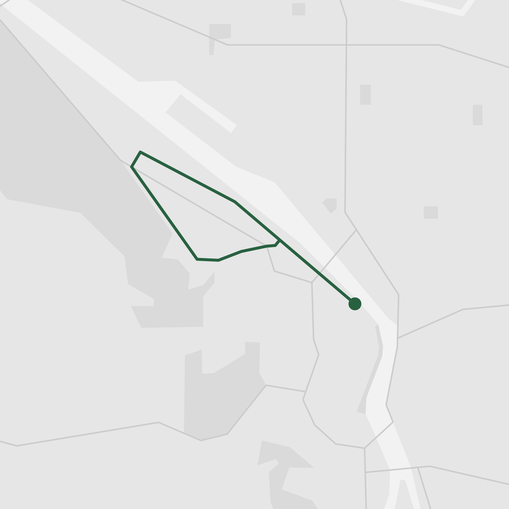
5. Willamette Bluff
Start & Finish: Overlook Park & Cathedral City Park.
Course Profile: 5.8 miles, 122 ft+ (Strava Route)
Road Type: City streets.
Auto Traffic: Low.
6. Columbia Slough
Start & Finish: Kenton Park (out and back).
Course Profile: 6.6 miles, 78 ft+ (Strava Route)
Road Type: Urban trails and city streets.
Auto Traffic: Minimal.

Course Overview: Willamette Blvd in North Portland is a hidden gem for runners. Right above the bluff looking out over the Willamette River, this route offers great views of the city skyline and Forest Park and has low cross traffic (most intersections are three-way). Better yet, it connects two really fun neighborhoods: Boise, which is more commonly known as “Mississippi” for the funky art scene and local stores on Mississippi Ave, and the hugely underrated St. Johns in the far northwest.
Columbia Slough trail is another great place for running, especially if you enjoy a relaxing run with open views. The trail traces Columbia Slough for about 3 miles between N Vancouver Ave and N Portland Rd, with green spaces on both sides for the majority of the trail. Kenton is a good place to start and finish the out-and-back run, with easy access to public transit and a few nice cafés in the neighborhood.
Course Highlights: St. Johns Bridge, Cathedral City Park, Overlook Park, Mississippi Arts District, Adidas Headquarter, University of Portland, Paul Bunyan Statue.
Northeast
7. Ainsworth & Parks
Start & Finish: Peninsula Park & Grant Park.
Course Profile: 8.4 miles, 261 ft+ (Strava Route)
Road Type: City streets.
Auto Traffic: Medium.
8. Rocky Butte
Start & Finish: NE Fremont St at NE 92nd St (loop).
Course Profile: 3.2 miles, 430 ft+ (Strava Route)
Road Type: City streets.
Auto Traffic: Low.

Course Overview: Northwest Portland is mostly residential. Streets are in grid layouts and a number of them designated as neighborhood greenways, which prioritize people walking and bicycling (this practice goes back way before COVID). These “slow” streets, including NE Holman St, NE Going St, NE Klickitat St, and NE Tillamook St, are perfect, though not the most exiting, routes for morning jogs.
Consider instead NE Ainsworth St. This boulevard-like street links up three beautiful parks (Peninsula Park, Alberta Park, and Fernhill Park) and has a narrow green belt between in the middle of the street, which encourages pedestrian activities and as a result reduces vehicle speed. Two more parks (Wilshire Park and Grant Park) can be added to this route, with the possibility of finishing the run with some strides in the Grant Track.
A bit farther to the east, a 5K loop around Rocky Butte Natural Area is ideal for a moderate hill session and rewards you with awesome views of the Northern part of Portland.
Course Highlights: Alberta Arts District, Peninsula Park Rose Garden, Rocky Butte Natural Area.
Northwest
9. Industrial Loop
Start & Finish: The Fields Park.
Course Profile: 7.1 miles, 88 ft+ (Strava Route)
Road Type: City streets.
Auto Traffic: Medium.
Course Overview: Northwest Portland is the small triangular area north of Burnside St sandwiched between Forest Park and Willamette River. Famous for its trendy shopping and dinning scene, it is not ideal for serious running. Running in Northwest Portland means constantly crossing local streets and checking for traffic, even though car speed is usually low in these extremely walkable neighborhoods.
There is one exception: the Northwest Industrial. This area along US Route 30 (NW Yeon Ave) is almost entirely industrial with gigantic manufacturing plants and warehouses. NW Front Ave and NW St Helen Rd are long and straight with few 4-way intersections. They together create a loop that is my favorite route for a morning tempo run.
Course Highlights: NW 23rd Ave Business District, Pearl District.
Southwest
10. Fairmont Loop
Start: W Burnside St at SW Vista Ave (out and back).
Course Profile: 7.8 miles, 880 ft+ (Strava Route)
Road Type: City streets.
Auto Traffic: Low.
11. Terwilliger
Start: W Burnside St at SW Vista Ave (out and back).
Course Profile: 7.8 miles, 880 ft+ (Strava Route)
Road Type: City streets.
Auto Traffic: Low.

Course Overview:
If I can pick one personal secret route in Portland to really goes beyond the tourist hotspots, it is Vista Ave to Fairmont Blvd Loop. Consisting entirely of city streets, this route is surprisingly scenic yet unexpectedly challenging. To get through the long, steep climb of Vista Ave, think of the beautiful hillside houses at the top. You won't get one as a reward but I think even just the view of them is worth the effort.
While downtown area isn't usually where runners go, I wouldn't mind taking a jog around South Park Blocks. Thanks to its proximity to Portland State University, this green belt of one block wide and twelve blocks long is significantly calmer than its neighboring streets, with a few blocks accessible to pedestrian only.
Course Highlights: Vista Bridge, Council Crest Park, Fairmont Blvd Vista Point; Pioneer Sqaure, Park Blocks, Powell's City of Books
Southeast
12. Oaks Bottom - Reed College
Start & Finish: SE Spokane St at SE 13th Ave (loop).
Course Profile: 7.4 miles, 320 ft+ (Strava Route)
Road Type: City streets.
Auto Traffic: Low.

Course Overview : Southeast Portland seems to have the perfect level of energy. It has several business districts stretching more than a few blocks and attract locals from all over the city, but still seems calm and relaxed, especially in comparison to the tourists-packed Downtown and Pearl District across the river. In my eyes this is the local's Portland.
SE Salmon St and SE Lincoln St are neighborhood greenways that are ideal for running and both streets lead perfectly to entrances to Mt. Tabor Park. Whether or not you would like to throw in a loop or Mt. Tabor Park or Laurelhurst Park, I highly recommend finishing the run on Hawthorne Blvd (ideally between SE 30th Ave and SE 50th Ave) and explore this bustling corridor that retains the funky spirit of Portland.
Further south, there are a couple of short nice running routes around the Sellwood-Moreland neighborhood. Oaks Bottom Wildlife Refuge, encircled by an urban trail (Springwater) and a dirt trail (Bluff trail), is a little urban oasis for nature loving runners. Reed College Parkway is a peaceful boulevard featured in the course of Portland Marathon (in fact, it is the only segment that is run back and forth).
Course Highlights: Ladd's Addition, Hawthorne Business District, Mt. Tabor Park, Laurelhurst Park; Oaks Bottom Wildlife Refuge; Reed College Parkway.
South
13. Tryon Creek
Start: Duniway Park.
Finish: N State St at A Ave (Lake Oswego, OR)
Course Profile: 7.8miles, 636 ft+ (Strava Route)
Road Type: City streets and dirt trails (optional).
Auto Traffic: Low.

Course Overview: Technically, South Portland is the tiny narrow corridor along Interstate 5 along the Willamette River that, except for the riverfront trail as part of the Waterfront Loop, isn't very exciting for running. On the contrary, Southwest Portland is packed with fantastic running trails. So I think it's OK to to give this section Terwilliger Blvd, a thoroughfare that stretches all the way outside Portland's south border.
One of the my favorite running route, Terwilliger is peaceful and scenic, despite a modest level of traffic. It connects downtown Portland to Tryon Creek State Natural Area and further south to Lake Oswego. The 7.8-mile route features a few terrific view points, multiple interesting options of natural trails in Tryon Creek State Natural Area, and the possibility of extending itself by a 6.8-mile loop of Lake Oswego.
Course Highlights: Terwilliger Boulevard view points, Tryon Creek State Natural Area, Foothills Park.
Excursions
North
14. Marine Dr
Start: NE Marine Dr at NE 112nd Ave.
Finish: NE Marine Dr at N Kelley Point Park Rd.
Course Profile: 14.2 miles, 186 ft+ (Strava Route)
Road Type: City Street.
Auto Traffic: Low.
15. I-5 Bridge (to Vancouver)
Start: Kenton Park.
Finish: Waterfront Park (Vancouver, WA)
Course Profile: 7.6 miles, 230 ft+ (Strava Route)
Road Type: City Street.
Auto Traffic: Medium.

Course Overview: The Willamette River isn't the only river runs through Portland, not even the largest. Columbia River, the fourth largest river in the United States and of whom the Willamette is a tributary, defines Portland's city limit in the north. Marine Dr trail is a multi-use path that traces the Columbia River for almost the entire width of Portland. With a flat profile, few intersections and grand views of the Columbia River, it is a prime route for running and cycling. While Marine Dr lies along Portland's north border, one can reach the trail by bus, MAX light rail, or connection trails (N Lombard St in the west, I-205 trail in the east). At the west end of Marine Dr, Kelley Point Park looks out to the Willamette as it merges into the Columbia.
Columbia River also serves as the state line between Oregon and Washington. Across the river is Vancouver, WA, the fourth largest city of Washington State. A medium long run is all it takes to explore Vancouver's beautiful waterfront and downtown area. From there, an express bus ride can take you back to Portland downtown.
Course Highlights: Kelley Point Park, Portland International Airport, Delta Park, Vancouver Waterfront.
East
16. Springwater Corridor
Start: SE Ivon St at SE 4th Ave (Springwater Corridor trailhead).
Finish: Main City Park (Gresham, OR).
Course Profile: 15.5 miles, 300 ft+ (Strava Route)
Road Type: Urban trail.
Auto Traffic: None.
17. Powell Butte
Start & Finish: SE Powell Blvd at SE 162nd Ave.
Course Profile: 4.7 miles, 790 ft+ (Strava Route)
Road Type: Dirt trail.
Auto Traffic: None.

Course Overview: If you have done the Waterfront Loop (long version) , you are not strangers to Springwater Corridor trail. This 21-mile long multi-use trail starts near Tilikum Crossing Bridge, then it traverse southeast Portland and reaches Gresham historic downtown before continuing to Boring, OR (what a name!) Easy access to the trail and long uninterrupted segments make it a very popular urban trail among runners and cyclists.
At about 8 miles into Springwater Corridor trail from the Willamette riverfront is the intersection with I-205 trail. This multi-use trail runs north-south across East Portland along Interstate 205. While it isn't a very pleasant trail due to scattered homeless encampments, it is a useful connector trail for runners who do not wish to go east of I-205. MAX light rail also runs along this trail.
Also along Springwater Corridor trail is Powell Butte Nature Park, the largest and most fun park for running in eastside Portland. The park boasts deep woods with cool shades and intertwining trails, as well as a completely exposed meadow with open views. Runners can access the park through Springwater Corridor or SE Powell Blvd that is served by local buses.
Course Highlights: Powell Butte, Historic Downtown Gresham.
South
18. Trolley Trail (to Oregon City)
Start: SE Lynn St at SE 17th Ave
Finish: Main St at 7th St (Oregon City, OR)
Course Profile: 10.1 miles, 265 ft+ (Strava Route)
Road Type: Urban trail and city Streets.
Auto Traffic: Low.
19. Lake Oswego Loop
Start & Finish: Millennium Plaza Park (Lake Oswego, OR).
Course Profile: 6.8 miles, 525 ft+ (Strava Route)
Road Type: City Street.
Auto Traffic: Low.

Course Overview: When Terwilliger Blvd ends in Lake Oswego, new adventures are only about to start. To continue running, one can take the moderate 7ish-mile loop around Lake Oswego. This isn't really a scenic lakefront route, nevertheless it is peaceful and relaxing, with a few nice lookout points.
Instead of running around the big lake, you can keep going south and reach Oregon City in about 5.5 miles. Adding this on top of Terwilliger Blvd, you can run to Oregon City from Downtown Portland in a little bit over a half marathon. Pretty close neighbors considering that they are the county seats of two different counties.
This is not even the only way to get to Oregon City in running. Trolley Trail on the other side of the Willamette River is another option. This eastbank route is slightly longer but flatter and features a pleasant waterfront segment along Clackamas River shortly before arriving in Oregon City.
Course Highlights: Milwaukie Bay Park, Clackamette Park, Oregon City, Willamette Falls Scenic Viewpoint.
West
20. Sunset Hwy Trail (to Nike HQ)
Start: SW Canyon Ct at SW Canyon Rd.
Finish: One Bowerman Dr at SW Murray Blvd (Beaverton, OR)
Course Profile: 5.9 miles, 210 ft+ (Strava Route)
Road Type: Urban trail and city Streets.
Auto Traffic: Low.

Course Overview: Portland's west hills are very exciting for runners, but on the other side of these hills, not so much. Although there are plenty of local trails and running routes in Beaverton and Hillsboro, there isn't any directly connecting Portland and its neighbors to the west.
Maybe we can count Sunset Hwy trail in. This multi-use trail starting from just outside Washington Park doesn't go very far, but it provides an easy way to get to Nike's World Headquarter in Beaverton, OR. Nike's campus isn't supposed to be open to public but enforcement varies according to individual experiences shared online. If you don't plan to run back, MAX light rail Beaverton Creek Station is about 20 minutes walking distance from Nike's HQ. The train goes to Downtown Portland via Downtown Beaverton.
Course Highlights: Nike Headquarter.