Routes
Chicago offers an impressive variety of routes that showcase both its urban beauty and easy access to nature. The Lakefront Trail is the centerpiece, a stunning 18-mile path along Lake Michigan linking downtown with a chain of lakefront parks, including Grant, Lincoln, and Jackson Parks, each offering open green space and skyline or waterfront views. On the city’s northwest side, The 606 provides a 2.7-mile elevated path through vibrant neighborhoods like Wicker Park and Logan Square, ideal for quick runs or tempo workouts. Beyond these well-known spots, Chicago’s historic Boulevard System connects parks such as Humboldt, Douglas, and Garfield via leafy, wide avenues perfect for exploring the city’s neighborhoods on foot. For those seeking quieter, longer routes, the suburban trail network, including the North Branch Trail, Illinois Prairie Path, and Des Plaines River Trail, offers shaded miles through forest preserves and along rivers, providing a peaceful contrast to the city’s energetic lakefront miles.

1 & 2. Lakefront Trail


The Chicago Lakefront Trail (LFT) is a multi-use path that stretches for 18.5 miles along the shore of Lake Michigan. The trail is open and scenic, flat and well maintained, it is the most popular destination for running and cycling in the city.
- North
• Start & Finish: Grant Park to Kathy Osterman Beach
• Route Profile: 8.5 miles, flat, multi-use path
This route covers the northern half of the Lakefront Trail, from Grant Park to Kathy Osterman Beach. Due to its central location and excellent lakefront views, this section is often crowded, with walkers, runners, and cyclists sharing the path.
There is a series notable parks and landmarks along this route:
- Chicago Riverwalk (see Route #4)
- John Hancock Center: one of Chicago's most iconic skyscrapers, visible from the LFT.
- Gold Coast: one of Chicago's most affluent and historic neighborhoods, renowned for its elegant mansions and tree-lined streets. Along the lakeshore, you'll find Oak Street Beach, a popular destination that offers stunning views of Lake Michigan and the city skyline (P5).
- Lincoln Park (see Route #5)
- Belmont Harbor: the popular harbor offer addituional trails to enjoy the lakefront green space.
- Montrose Area: The well-maintained track at Montrose is a favorite among local runners, with many run clubs hosting their workout sessions here. Nearby, there are Montrose Beach and Montrose Point Bird Sanctuary.
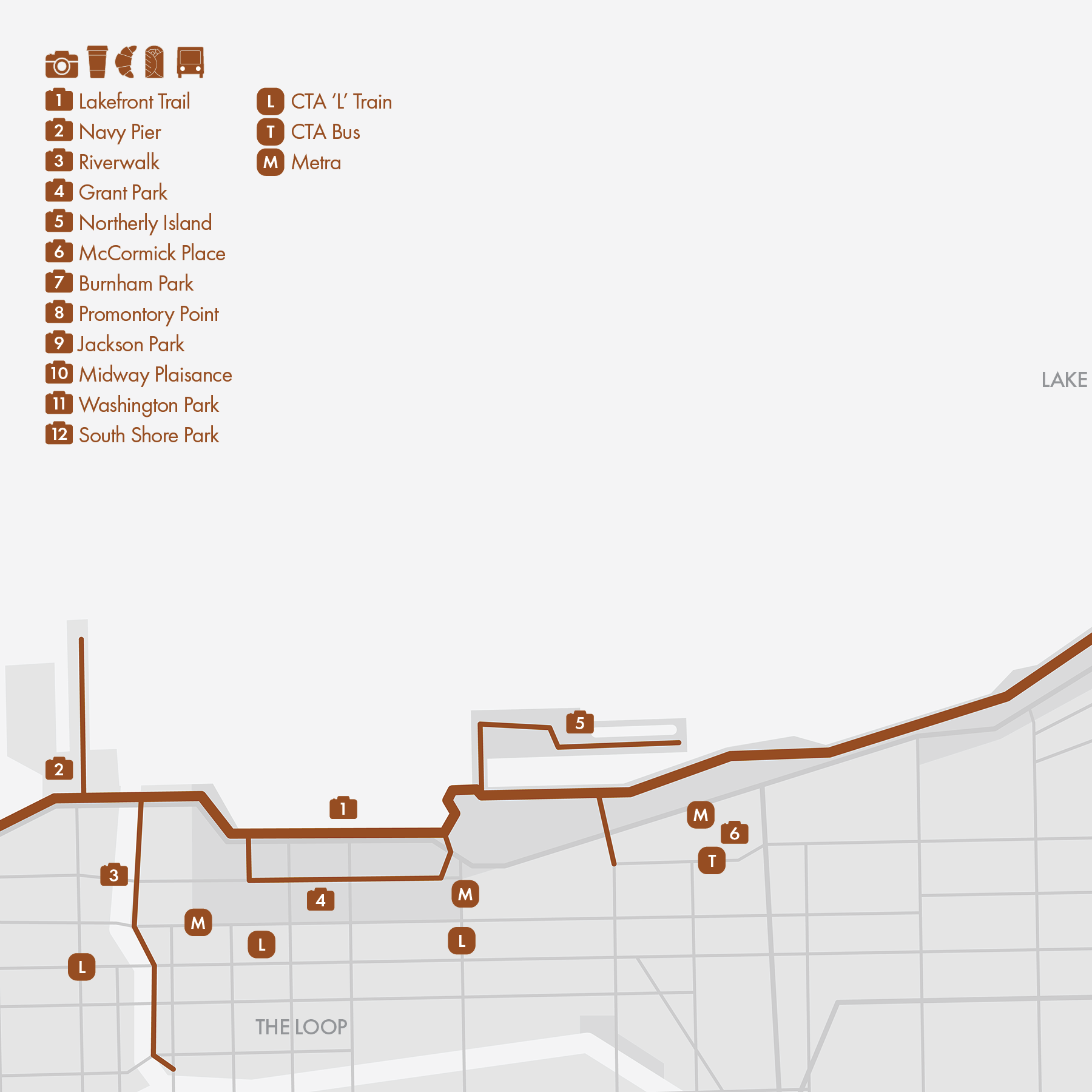
- South
• Start & Finish: Grant Park to South Shore Park
• Route Profile: 9.15 miles, flat, multi-use path
This route covers the southern half of the trail, from Grant Park to Chicago's South Shore neighborhood. It's much quieter and less crowded than the northern half of the trail and is ideal for some speedy tempo work. There is a series of notable parks and landmarks along this route:
- Grant Park and Northerly Island (see Route #3)
- McCormick Place: the largest convention center in North America. It is named after Robert R. McCormick, a prominent Chicago businessman and former editor and publisher of the Chicago Tribune. Every October, McCormick Place hosts the race expo of Chicago Marathon.
- Burnham Park: the big park spans along Chicago’s Lakefront between Museum Campus and Jackson Park. It features green space, recreational facilitiues, several public beaches and Promontory Point, a manmade peninsula with scenic views and tranquil spaces.
- Jackson Park (Route #8): the historic and expansive park in South Chicago features beautiful lagoons, various walking trails, a Japanese garden, the Statue of The Republic and the Museum of Science and Industry. It is designed by the famous landscape architects Frederick Law Olmsted and Calvert Vaux.
Run Clubs / The northern section of the Lakefront trail is a staple for many local run clubs, including @heartbreak.chi @lakeviewrunclub @goldcoastrunclub @fleetfeetchicago; @7onsundays is a Chicago south side run club that's active on this southern part of LFT.
Cafe / There are many interesting neighborhoods along the north side of the Lakefront Trail, including Old Town, Lincoln Park, Lakeview, Uptown, each offering an abundance of café options. There are water fountains and restrooms along the south side of the Lakefront Trail, but outside of the Loop and Hyde Park, it requires a substantial detour to find even a Starbucks.
Transit / CTA 'L' Red and Brown trains run through Chicago's north side, with many stations not far from the Lakefront Trail, All CTA 'L' trains run through the Loop; the Green Line serving neighborhoods in South Chicago a couple of miles away from the trail. Neighborhoods along the Lakefront Trail is also well served by CTA buses.


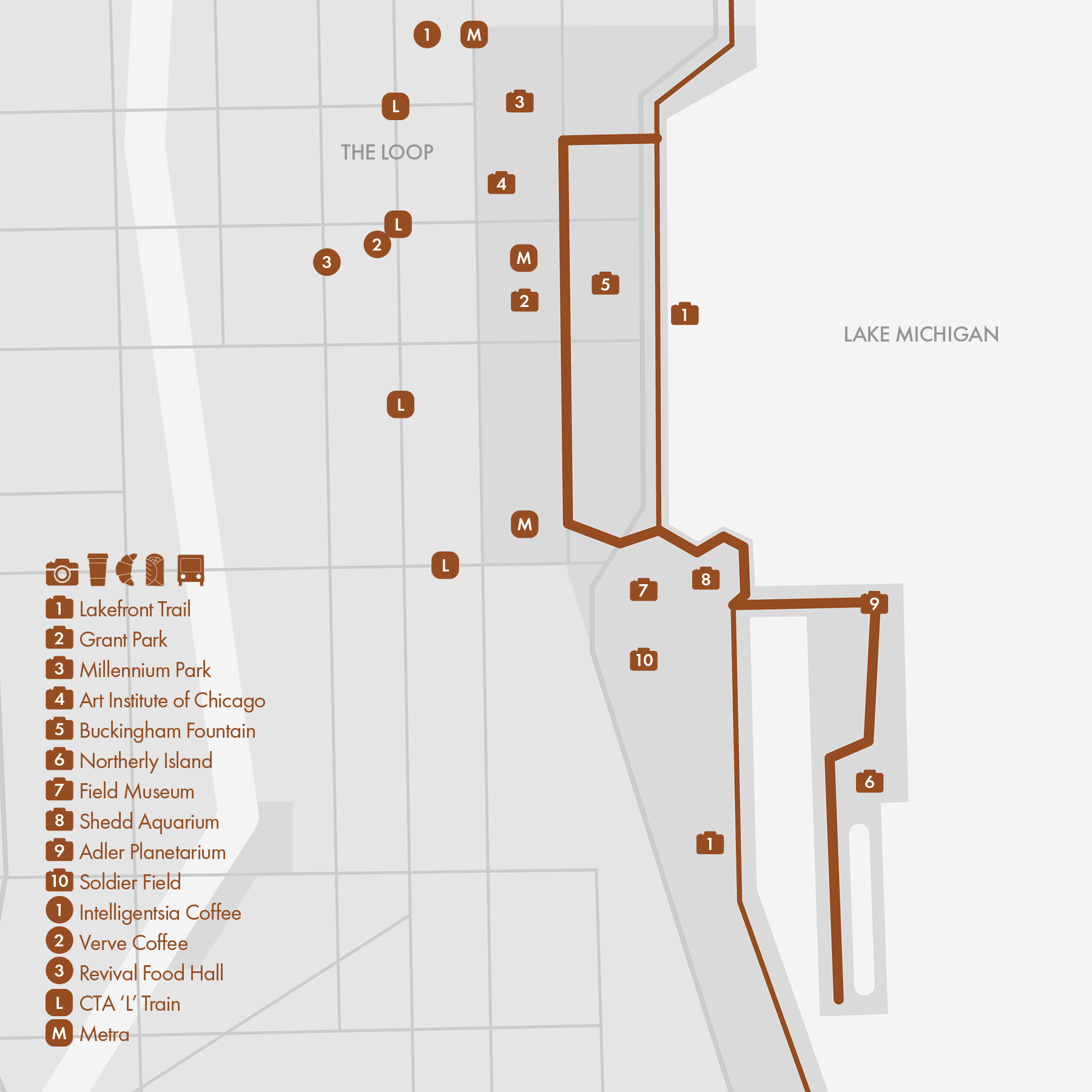
3. Lakefront: Grant Park

• Route Profile: various route options
Grant Park is a large urban park in the heart of Chicago, serving as a hub for recreation, cultural events, and major city celebrations. The park features numerous walking paths, with the Lakefront Trail running along its eastern edge. Grant Park is also the start and finish location of the Chicago Marathon @chimarathon
Notable Places in and near Grant Park:
- Millennium Park: A modern addition to Grant Park featuring landmarks such as Cloud Gate (commonly known as "The Bean"), the Crown Fountain, and the Jay Pritzker Pavilion.
- Art Institute of Chicago: One of the oldest and largest art museums in the United States, housing a vast collection of artworks, including iconic pieces like Edward Hopper's "Nighthawks," Grant Wood's "American Gothic," and Georges Seurat's "A Sunday on La Grande Jatte."
- Buckingham Fountain: Built in 1927, this is one of the largest fountains in the world, known for its impressive water displays.
- Northerly Island: This scenic peninsula has transformed over the years from an airport to a beautiful nature area and recreational destination. It features miles of walking trails with views of Lake Michigan and the Chicago skyline, including a loop around the lagoon with a paved western side and an unmaintained eastern side.
- Museum Campus: Located between Grant Park and Northerly Island, it is home to three of Chicago's most renowned museums: the Field Museum of Natural History, Shedd Aquarium, and Adler Planetarium.
- Soldier Field: The iconic multi-purpose stadium opened in 1924 and is one of the oldest stadiums in the NFL, serving as the home field for the Chicago Bears.
Cafe / Grant Park is situated in one of the most touristy areas of Chicago, offering plenty of dining options in the Loop. While there are many choices, there aren't many hidden gems.
Transit / This area is very well served by public transit, including CTA 'L' trains, buses, and Metra commuter rails.
4. Lakefront: Riverwalk

• Route Profile: 2.5 miles, flat, waterfront promenade
The Riverwalk is a vibrant and scenic waterfront promenade along the south bank of the Chicago River in downtown Chicago. Stretching from its east end at Lake Street, the Riverwalk runs parallel to Wacker Drive on the lower level, and connects to the Lakefront Trail. This route then continues to Navy Pier by utilizing the overpass along Lake Shore Drive. This highly touristy area is rich with landmarks and interesting places to explore, making it ideal for an easy sightseeing run rather than a speedy one.
The Riverwalk offers stunning views of the Chicago River, and the city's iconic skyline. It passes by several notable architectural landmarks, including the Merchandise Mart, Marina City Towers, Tribune Tower, and the Wrigley Building. Along the promenade, you'll find a wide range of restaurants, cafes, and bars with outdoor seating. Visitors can also enjoy various recreational activities including kayaking, boat tours, and water taxis.
The second part of this route, Navy Pier, is one of Chicago's most popular and iconic attractions, offering a mix of entertainment and dining establishments, excellent views of Lake Michigan, and a series of public art installations and gardens. Ohio Street Beach by Navy Pier is a sandy public beach popular for open-water swimming.
Nearby on The Magnificent Mile, Chicago's premier commercial district along Michigan Avenue, several running brands have their stores, including Nike, Adidas, HOKA, and Under Armour.
Cafe / Espresso & Milk in the Opera Building near the east end of Riverwalk is excellent (but only opens on weekdays); there is also a good concentration of cafes between Merchandise Mart and River North.
Transit / The north edge of CTA 'L' Loop is just a block south of the Riverwalk; Navy Pier is the terminus for several CTA bus routes.

5. Lakefront: Lincoln Park

• Route Profile: 4.1 miles, mostly flat, paved and crushed gravel multi-use trails
Lincoln Park is a one of Chicago's largest and most popular parks, located along the Lake Michigan shoreline in the city's north side.
DuSable Lake Shore Drive, an expressway, runs along the east side of Lincoln Park by the lakeshore. Between the expressway and the lake is the famous Lakefront Trail (Route #1), a top running destination in Chicago. This section of the trail through Lincoln Park offers magnificent lake views against the backdrop of the Chicago skyline. On the west side of the expressway, you can find Diversey Harbor, ponds and lagoons, athletic fields, as well as Lincoln Park Zoo and Lincoln Park Conservatory. The park features numerous interconnected trails, with several overpasses and underpasses connecting these trails to the Lakefront Trail.
Lincoln Park, the namesake neighborhood to the west of the park, features a blend of historic and modern architecture and is renowned for its vibrant nightlife. Armitage Ave, Halsted St, Lincoln Ave, Clark St, and Broadway are particularly noted for their shops, cafes, and restaurants. The neighborhood is also home to Oz Park, a whimsical park adorned with statues of characters from "The Wonderful Wizard of Oz."
Many running clubs are active in this area, including:
- Heartbreak Hill Running Company @heartbreak.chi: This specialty running store located on Halsted Street hosts a Thursday night signature speed session in Lincoln Park and a Saturday long run along the Lakefront Trail.
- West Town Brew Crew @westtownbrewcrew: This Friday morning run group often features coffee shops in the area and may even include a mid-run Lake Michigan plunge!
- Fleet Feet Old Town: This running store also hosts weekly group runs.
Cafe / A ton of options in this area! My personal favorite is Printer Row's Coffee and Coffee Lab (outside this map) on Lincoln Ave.
Transit / The CTA 'L' Brown and Red Lines serve the Lincoln Park neighborhood. Bus routes 22 and 36 run along Clark Street on the west side of Lincoln Park.

6. Park & Boulevard: Logan - Humboldt
Logan Square and Humboldt Park are situated at the northwest corner of the Chicago Park & Boulevard System. Logan Square is connected to the Lakefront Trail to the east via Logan Blvd and Diversey Pkwy; to the south, the System continues with Garfield Park (Route #7) following Humboldt Park. Additionally, The 606 Trail (Route #9) runs through this area, while the 312 RiverRun (Route #10), located 1.5 miles north, links this area to a network of other trails in northern Chicago.
- Logan Square
• Route Profile: 4.9 miles loop (out-and-back), flat, city streets
Logan Square is a vibrant and historic neighborhood renowned for its diverse community, historic architecture, tree-lined boulevardsand bustling arts and food scenes. This route runs out and back along Logan Blvd, Kedzie Blvd and Humboldt Blvd, passing through Logan Square Park and Palmer Park.
- Humboldt Park
• Route Profile: 2.15 miles loop, flat, paved path
Humboldt Park (cover, P5-6) is one of the largest parks on the West Side of Chicago. It features extensive walking trails, a wide range of recreational amenities, a boathouse, a historic fieldhouse, and a formal garden.
Many run clubs are active in this area, including
- @3run2 Thur night BLVDS run starts from Logan Square and traces the boulevards to Humboldt Park and back;
- Humboldt Park is home to @runtoohard, who meets Tuesday morning for social miles and post-run coffee.
- You'll also find Blue Line RC and @westtownbrewcrew in the area, among others.
Cafe / Logan Square and its adjacent neighborhoods, like Wicker Park, are home to an abundance of great coffee shops and cafes. Some of my favorites include Four Letter Word, thrd coffee, Prequel Cafe, Mindy's Bakery, and Lost Larson. (I need to check out Frera Desserts!)
Transit / The CTA 'L' Blue Line runs along Milwaukee Avenue, with a station in Logan Square. Major east-west streets are all well served by CTA buses, including routes 66 (Chicago), 70 (Division), 72 (North), 73 (Armitage), 74 (Fullerton), and 76 (Diversey).
7. Park & Boulevard: Garfield - Douglass

Garfield Park and Douglass Park are two major parks on the West Side of Chicago. They are key components of the Chicago Park & Boulevard System, with Humboldt Park (Route #6) to the north and Washington Park (Route #8) to the (distant) southeast.
- Garfield Park
• Route Profile: 1.25 miles loop, flat, paved path
Garfield Park (cover, P3-5) boasts an extensive trail network, numerous recreational facilities, a beautiful lagoon, and a striking gold dome fieldhouse. The Garfield Park Conservatory (P6), one of the largest and most impressive in the United States, showcases a wide variety of plant collections housed in several distinct indoor gardens.
- Douglass Park
• Route Profile: 1.75 miles loop, flat, paved path
Similar to Garfield Park, Douglass Park (P7-8) features excellent walking trails, a variety of sports and recreational amenities, and beautiful gardens and lagoons.
As the name of the Chicago Park & Boulevard System suggests, these parks are connected by wide boulevards, often featuring green spaces between the two directions of traffic. Douglas Boulevard is particularly beautiful, with a walking trail in the green space that offers a better running experience than the sidewalks along the boulevard.
Garfield Park, Douglass Park, Humboldt Park, and the connecting boulevards form the course of the Bank of America Chicago 13.1 Half Marathon. For 2024, the race starts and finishes in Garfield Park, although the course is subject to change.
Run Cubs / Peace Runners 773 is a running club that meets in Garfield Park, while Viento Little Village Runners Club is active in Little Village, located southwest of Douglass Park.
Transit / Three CTA 'L' lines serve this area. The Green Line's Conservatory-Central Park Drive Station is located in Garfield Park. The Blue Line runs along the south end of Garfield Park. The Pink Line's California Station is just outside the southeast corner of Douglass Park.

8. Park & Boulevard: Washington - Jackson
Washington Park and Jackson Park are two of Chicago's largest and most historically significant parks, and part of Chicago's Park and Boulevard System. They are connected by the Midway Plaisance and are adjacent to the Lakefront Trail, making this area the premier running location on the South Side of Chicago.
- Washington Park
• Route Profile: 3.0 miles loop, flat, paved path and crushed gravel trail
Washington Park boasts an extensive network of running paths, with an outer loop along the roads and a popular figure-8 inner loop. The park features beautiful landscapes, including open meadows, lagoons, and mature trees. Additionally, the park includes an arboretum and is home to the DuSable Museum of African American History.
- Jackson Park
• Route Profile: 3.6 miles loop, flat, paved path
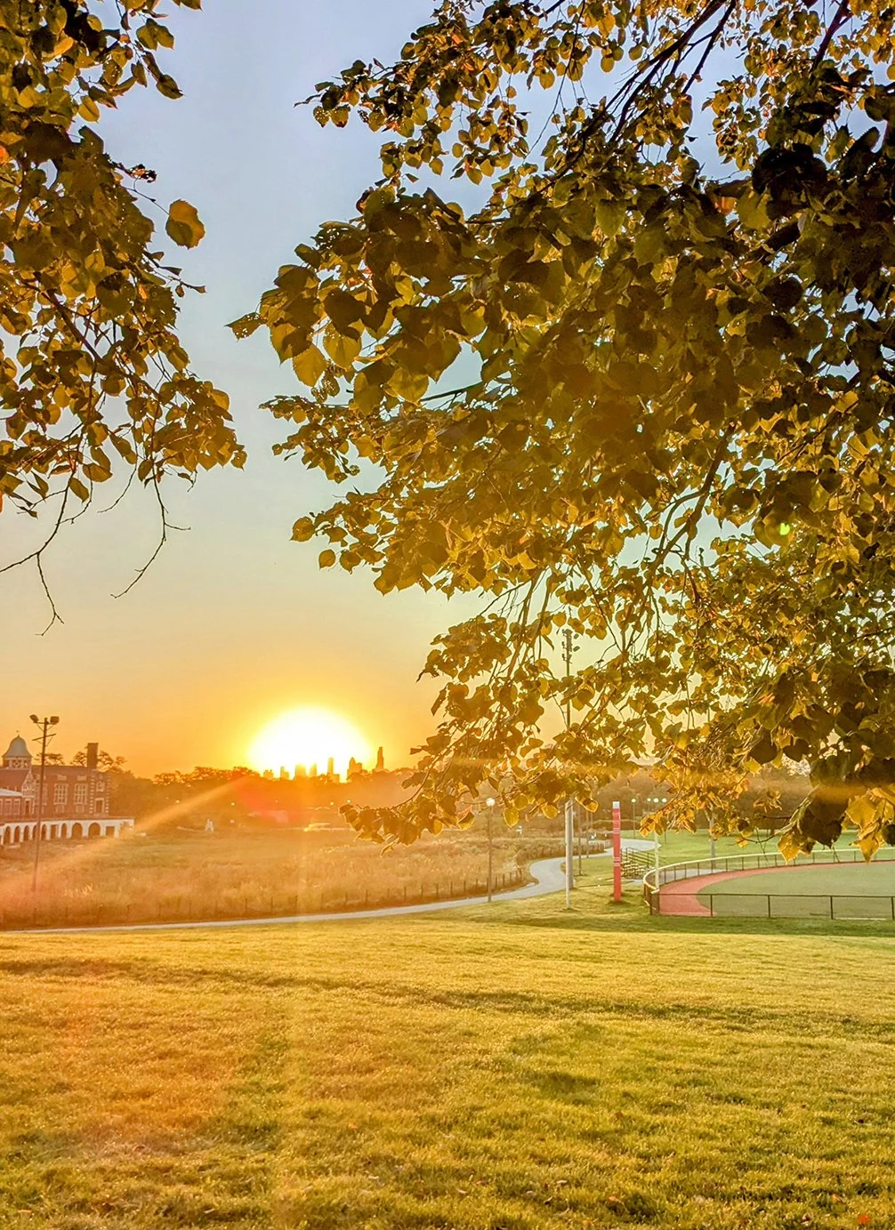
Like Washington Park, Jackson Park has extensive running trails with three underpass access points to the Lakefront Trail. The park's lagoons are a central feature, with a serene natural area island and the Gardens of the Phoenix (cover), a Japanese garden that is a hidden gem. Located on the north side of the park is the Museum of Science and Industry (seen in cover!).
- Midway Plaisance
• Route Profile: 1 mile one-way, paved path
The mile-long linear park between two major parks features expansive lawns, tree-lined boulevards, and picturesque walking paths. Adorned with several statues and monuments, it is also adjacent to the renowned University of Chicago campus.
Situated bewteen Washington Park and Jackson Park, just north of Midway Plaisance is the Hyde Park neighborhood. Known for its cultural diversity, academic influence, and architectural beauty, Hyde Park is home to the University of Chicago and a host of cultural landmarks.
Cafe / There is no shortage of cafes in the Hyde Park neighborhood, and I had a great experience at Built Coffee, a charming coffee shop just south of Midway Plaisance.
Transit / The CTA 'L' Green Line runs on the west and south sides of Washington Park, while Metra Millennium Park Like passes by Jackson Park.

9. The 606 Trail

• Start & Finish: Along Bloomingdale Ave between Ashland Ave and Ridgeway Ave
• Route Profile: 2.7 miles, flat, elevated multi-use path
The 606, also known as the Bloomingdale Trail, is an elevated park and multi-use trail on Chicago's northwest side. This urban greenway repurposes a former railway line into a beloved recreational space, stretching approximately 2.7 miles with multiple access points to crossing streets at ground level.
Along its route, The 606 connects to several ground-level parks and features native plants and public art installations. Walsh Park on the east end, has a playground and dog park; Damen Arts Plaza offers rotating public art exhibits Park; No. 567 by Milwaukee Ave is most famous for the ConAgraMural by Jeff Zimmermann ; and the west end of the trail is a small garden with a lookout mount.
The 606 intersects with Humboldt Blvd, part of Chicago's Park and Boulevard system (Route #6-8). South of this intersection lies Humboldt Park (Route #6), an iconic and culturally rich public park and provides additional running options in the area.
Along The 606 Trail, you'll find some of the most vibrant, hippest neighborhoods in Chicago, including Wicker Park, Bucktown, Humboldt Park, and Logan Square. Milwaukee Ave is one of Chicago's most important and lively thoroughfares known for its historical significance, eclectic neighborhoods, and numerous independent businesses from coffee shops to record stores.
Run Clubs / The 606 is very popular among local runners. You can find @6at6onthe606 on this trail every Monday morning and @runtoohard in the nearby Humboldt Park.
Cafe / Mindy's Bakery is excellent, so is thrd coffee. Dayglow offers an exciting coffee program, although their service is often subpar.
Transit / The CTA 'L' Blue Line intersects The 606 Trail, with both Damen and Western stations conveniently located near the trail. CTA buses service all major streets in the Chicago grid that run parallel to and intersect The 606 Trail.

10. 312 RiverRun

• Start & Finish: Along North Branch Chicago River between Belmont Ave and Montrose Ave
• Route Profile: 1.7 miles, flat, paved and grade separated multi-use path
312 RiverRun is a paved, multi-use path that stretches from Belmont Avenue to Montrose Avenue along the North Branch of the Chicago River. Despite its relatively short distance, this path is a vital component of the local park and trail network. It links three parks—Clark Park, California Park, and Horner Park—along the Chicago River's North Branch. Additionally, it connects to Diversey Parkway in the south, and to a couple of key regional trails in the north.
Major parks and trails along or connected to 312 RiverRun:
- Horner Park: This prominent public park offers a variety of recreational facilities and green spaces for the community, including a one-mile-long walking path.
- River Park: Situated one mile north of 312 RiverRun at the confluence of the North Branch of the Chicago River and the North Shore Channel, this park features recreational facilities and an 8-lane public track.
- From River Park, one can easily continue running on North Shore Channel Trail (Route #12), and North Branch Trail (Route #13) which is about 2 miles west.
- Jimmy Thomas Nature Trail: A small green space less than one mile southeast of 312 RiverRun that provides access to Diversey Parkway, part of Chicago's Boulevard System.
Cafe / Besides a few great coffee shops nearby the route, Lincoln Square and Logan Square are two vibrant neighborhoods flanking the route, each boasting an abundance of cafes.
Transit / 312 RiverRun is conveniently situated between two CTA lines: the Brown Line to the east and north of the route, and the Blue Line to the southwest. Additionally, all major streets on the grid are served by CTA buses.

11. North Shore Channel Trail

• Start & Finish: Along North Shore Channel between Lawrence Ave (south) and Green Bay Rd (north).
• Route Profile: 7.1 miles, mostly flat, paved multi-use path with street crossings
The North Shore Channel Trail runs alongside the North Shore Channel, a canal that flows from Lake Michigan in Evanston to the North Branch of the Chicago River in Chicago. For much of its length, the trail is tree-lined and partially shaded, offering a pleasant, cool environment for running.
The trail passes through a series of green spaces, including (from south to north) River Park, Legion Park (both have great sports and recreational facilities, and a nice public track in River Park), Lincolnwood Centennial Park and North Shore Channel Park (both parks feature fantastic outdoor displays of sculptures). Not far from the north end of the trail is Northwestern University, another place that's worth checking out.
Other Trails in this area:
• On the south side, this route can be connected to North Branch Trail (Route #13) and Skokie Valley Trail to the west, and 312 RiverRun (Route #10) to the south.
• On the north side, this route can be easily extended to Green Bay Trail (Route #12) which goes all the way to Wisconsin state border.
Cafe / Along the trail, there are some shopping malls and plazas featuring chain coffee shops. If you venture east off the trail on the south side, you'll discover the vibrant neighborhoods of Lincoln Square and Andersonville, both offering excellent cafe options. To the north, Evanston boasts a bustling downtown area that caters to all your needs.
Transit / Near the north end of the trail, Davis Station in Evanston is a transit hub for Metra (rail), CTA (rail and bus), and Pace (bus) services. The south end of the trail is close to the CTA Brown Line. Several CTA and Pace buses intersect with the trail, providing connections to either Davis or Kimball Station for CTA rail access.

12. Green Bay Trail

• Start & Finish: Wilmette Metra Station to Highland Park Station (9 miles) and further to Wisconsin State Line (31 miles)
• Route Profile: a mix of paved and crushed limestone surface
The Green Bay Trail is a multi-use path built on the former North Shore Railway bed, which once carried freight and passengers between the Chicago Loop and Downtown Milwaukee. After the railway service was discontinued in the 1950s, the rail line was converted into the Green Bay Trail in Cook County and the North Shore Trail in Lake County. These two connected trails were later renamed as the Robert McClory Bike Path, creating a 31-mile long, continuous route that stretches from Chicago's northern suburbs to the Wisconsin border.
Green Bay Trail–the section of the bike path in Cook County and next to Green Bay Rd–has great suburban surroundings. It passes through affluent suburbs like Wilmette, Kenilworth, and Winnetka, and offers a unique blend of natural beauty, historical significance, and community charm.
Other Trails in this area
• North Branch Trail (Route #13): This popular, wooded trail runs along North Branch Chicago River, about 2 miles west of the Green Bay Trail in Cook County.
• North Shore Channel Trail (Route #11): This multi-use path follows the North Shore Channel from Chicago to Evanston, where it ends on Green Bay Rd, 1.5 miles southeast of the south end of Green Bay Trail.
• Skokie Valley Trail: This 10-mile bike path runs parallel to and 2 miles west of the Robert McClory Bike Path in Lake County.
Cafe / The many downtowns along the trail offer easy access to coffee shops and restaurants. At the southern end of the trail, in Evanston, you'll find Hewn, widely considered one of the best bakeries in the Chicago area.
Transit / The south end of Green Bay Trail is one mile west of CTA Linden Station on the purple line. Metro UP-N Line runs next to Robert McClory Bike Path for 18 miles between Wilmette Station and Great Lake Station. Train stations are conveniently spaced every 2 to 3 miles, or even less in some areas.


13. North Branch Trail

• South End: Gompers (Samuel) Park
• North End: Skokie Lagoons
• Route Profile: ~18 miles, mostly flat and paved multi-use path, grade separated at most street intersections but there are some street crossings
North Branch Trail is a scenic and popular multi-use trail that follows the North Branch Chicago River from northwest Chicago to Skokie Lagoons and Chicago Botanic Garden in Glencoe, IL.
The trail is primarily paved with asphalt, with occasional sections in gravel. It goes through a string of parks, woods and nature preserves, though not as heavily forested as the Des Plaines River Trail. LaBagh Woods and Harms Woods are known for their bird watching opportunities; Bunker Hill is a popular picnic area with open fields and groves; at the north end, the 385-acre Chicago Botanic garden features 27 gardens and five natural habitats.
Other Trails in this area
• Green Bay Trail (Route #12): This multi-use path runs next to Green Bay Road and Metra UP-N Line in Chicago's northern suburbs.
• North Shore Channel Trail (Route #11): This multi-use path follows the North Shore Channel from its confluence with North Branch Chicago River at River Park to Evanston, IL, where the channel flows into Lake Michigan.
• Skokie Line Trail: This 4.5-mile multi-use path starts near the south end of North Branch Trail and ends next to CTA Yellow Line Dempster-Skokie station.
Transit / Although the North Branch Trail is surrounded by woods, it is located in a suburban area. It is easy to leave the trail and access nearby towns, where you can find food and transit options back to Chicago. Metra UP-N Line runs along the Green Bay Trail, its Glencoe Station is 1.5 miles away from the north end of the trail. Metra MD-N Line crosses the trail (twice) with three nearby stations: Edgebrook, Forest Glen, and Morton Grove. CTA Blue Line Montrose Station and Brown Line Kimball Station are both within 1.5 miles away from the south end of the trail. Some crossroads along the trail are served by Pace Bus, usually with connections to CTA stations.


14. Des Plaines River Trail

• South End: North Ave Trailhead (10 miles west of Chicago's Lincoln Park)
• North End: Russell Rd Trailhead (close to Illinois/Wisconsin state line)
• Route Profile: ~55 miles, mostly flat, unpaved trail, grade separated at most street and highway intersections but there are some unprotected street crossings so use caution!!
The Des Plaines River Trail is along, scenic and popular multi-use trail that stretches along the Des Plaines River in northeastern Illinois from Chicago's west suburbs to Wisconsin state line.
The trail is primarily unpaved with a crushed limestone surface, making it ideal for hiking, running, (gravel) biking, and horseback riding. It passes through more than a dozen forest preserves, where you'll find trail access points and parking spaces. You can also access the trail by public transit, see below for details.
I have only run a small section of the Des Plaines River Trail—an out-and-back run covering the 9-mile stretch between Milwaukee Avenue and Half Day Road. The trail is lush, tranquil, shaded in many parts, and well-maintained. Basic sign reading and trail wayfinding are needed at some intersections. I thoroughly enjoyed my run; trail shoes are not necessary though can be helpful.
Cafes / The Des Plaines River Trail is surrounded by nature, so be sure to bring hydration and fuel for your run. Alternatively, plan ahead for breaks in the nearby towns.
Transit / Several Metra Commuter Rail lines cross or run along the Des Plaines River Trail and their stations can be used to access the trail without a car:
- Mile 2: River Grove Station (MD-W & NCS Line)
- Mile 6: Rosemont Station (CTA Blue Line)
- Mile 11: Des Plaines Station (UP-NW Line)
- Mile 36: Libertyville Station (MD-N Line)
- Between River Grove (Mile 2) and Libertyville (Mile 36), NCS Line runs somewhat parallel to the trail, with several stations 1 to 2 miles away from the Des Plaines River Trail.


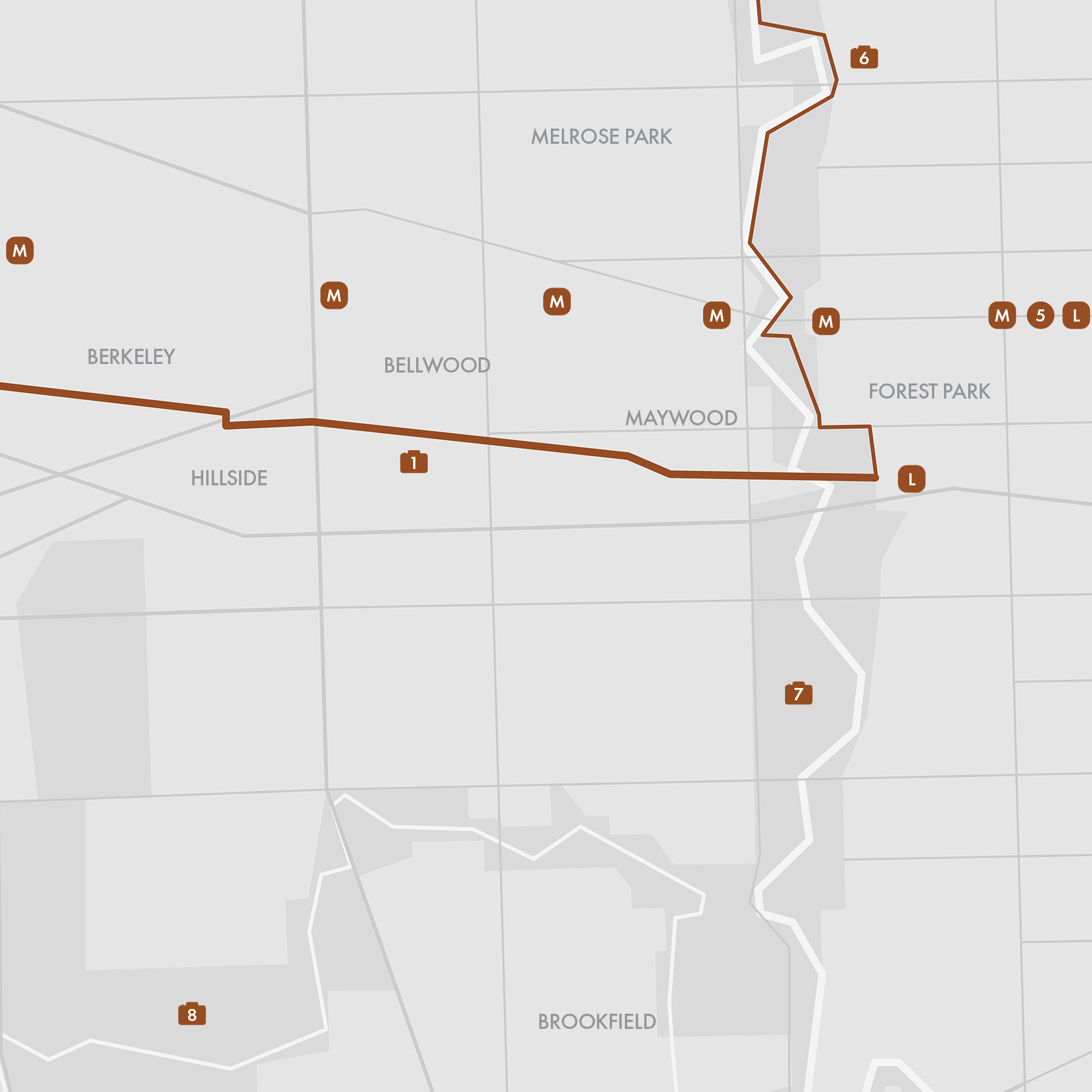
15. Illinois Prairie Path

• Start & Finish: Maywood Trailhead to Wheaton Trailhead.
• Route Profile: 15.7 miles, mostly flat, multi-use path, paved or crushed gravel, many city street intersections.
The Illinois Prairie Path (IPP) is a 61-mile network of multi-use trails located in the western suburbs of Chicago. The IPP features three distinct branches that converge at a trailhead near downtown Wheaton (P5).
• Main Stem: The 15-mile Main Stem is our recommended route. The eastern trailhead is located just west of the CTA Forest Park Station, not far from Oak Park, a vibrant Chicago suburb connected to the city via the CTA Green Line. The western trailhead is the Wheaton Trailhead, where all three branches converge. Along the path, you can enjoy the lively downtown scenes of Elmhurst, Glen Ellyn, and Wheaton, with the latter two towns featuring commuter rail stations conveniently situated right off the IPP path.
• Elgin (Northwest) Branch: This 14-mile branch extends from Wheaton northwestward to Elgin, IL. An alternate trail, the Geneva Spur, leads to Geneva, IL.
• Aurora (Southwest) Branch: This 13-mile branch extends from Wheaton southwestward to Aurora, IL. An alternate trail, the Batavia Spur, leads to Batavia, IL.
- Both branches and spurs end at the Fox River Trail, a 45-mile multi-use path along the Fox River.
• Naperville: the thriving Chicago suburb is another notable city in the IPP area. It is connected to the IPP via the DuPage River Trail, which branches off from the Aurora Branch. Downtown Naperville is approximately 10 miles from the Wheaton Trailhead.
Cafes / Take advantage of the suburban downtowns along the path for breaks and refueling. Villa Perk Coffee in Villa Park is a charming shop located right on the Main Stem, perfect for a quick stop.
Transit / The Main Stem starts at the CTA Blue Line's Forest Park terminus and runs somewhat parallel to the Metra UP-W Line. On the Elgin Branch, Elgin is served by the Metra MD-W Line, while West Chicago and Geneva are on the UP-W Line. On the Aurora Branch, both Aurora and Naperville are on the Metra BNSF Line.