Routes
Atlanta offers a diverse mix of urban and natural routes that make it a standout city for runners of all levels. The Atlanta BeltLine serves as the city’s signature route, an evolving 22-mile loop of multi-use trails connecting neighborhoods, parks, and public art, with the Eastside and Westside Trails especially popular for their lively energy and access to coffee shops and breweries. Piedmont Park, Atlanta’s green centerpiece, features scenic loops, rolling hills, and skyline views, often linking seamlessly with the Freedom Park Trail, which extends east toward the Carter Center and the PATH network. The PATH Foundation trails span much of the metro area, including favorites like the Stone Mountain Trail and Peachtree Creek Greenway. For a quieter, more natural escape, the Chattahoochee River National Recreation Area offers soft-surface trails with forested views and river breezes, while the Silver Comet Trail, a 60+ mile paved rail trail stretching from Smyrna into rural Georgia and Alabama, provides one of the best long-distance running routes in the Southeast.

1. Eastside Beltline & Piedmont Park
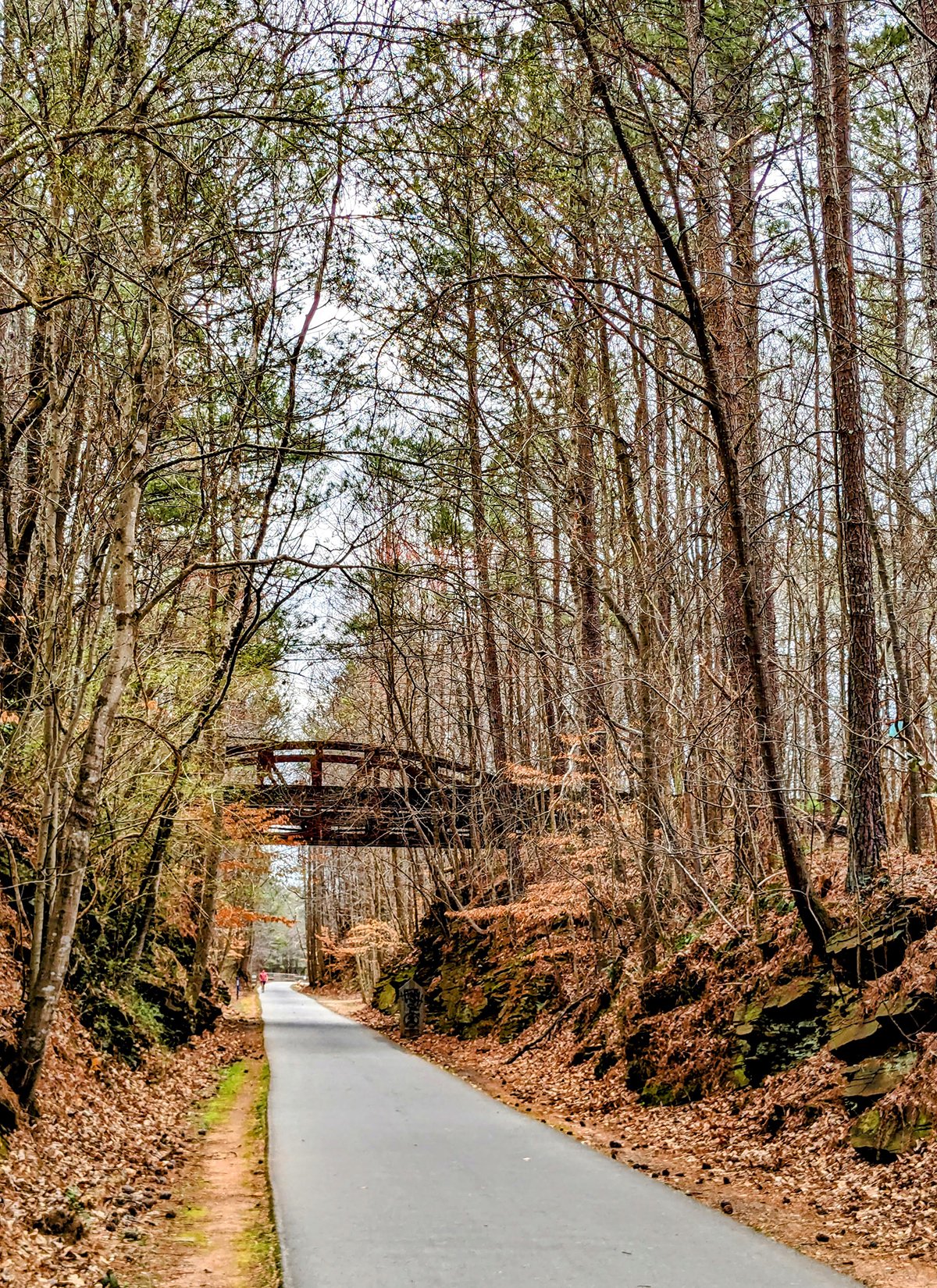
Atlanta's BeltLine project is an urban redevelopment initiative that aims to transform a former railway corridor into a 22-mile loop of multi-use trails encircling the city. The Eastside BeltLine is the most popular section, packed with art installations, trendy restaurants, cafés, breweries, and popular shopping areas.
- Eastside BeltLine
• Start & Finish: Trailhead under I-85 to Glenwood Ave
• Route Profile: 5.6 miles one-way, 228 ft+, multi-use path
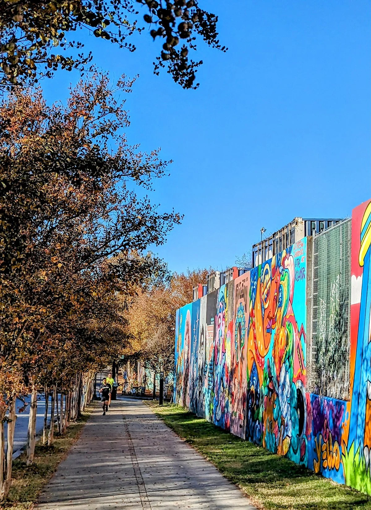
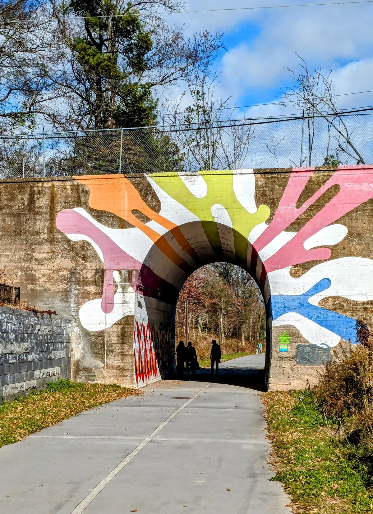
Between I-85 and Piedmont Park, the BeltLine is newly paved with no commercial activity. However, once you pass Piedmont Park, the trail becomes much busier with a mix of users, drawn by its central location and proximity to numerous apartment buildings. The vibrant energy is enhanced by local businesses, cafes, and shops that line the path. As you continue past Dekalb Ave into Reynoldstown, the trail becomes quieter again, but the stunning block-long mural wall along Wylie St is a must-see for anyone exploring the BeltLine. The Eastside BeltLine crosses Freedom Park Trail (Route #4), adding another fantastic urban running option.
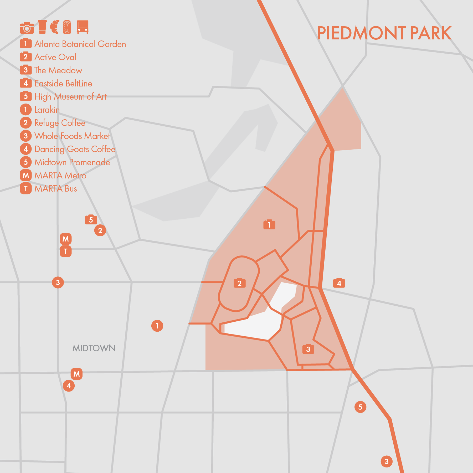
- Piedmont Park
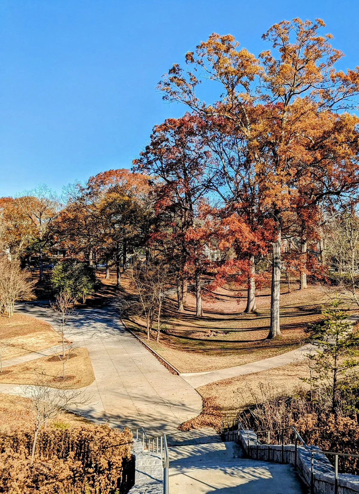
Piedmont Park is Atlanta's most iconic and expansive green space. Nestled in the heart of Midtown, it offers a serene escape amid the urban landscape. The park boasts gently rolling hills, sprawling open meadows, and over four miles of paved paths perfect for walking, running, or cycling. At its center lies the Active Oval, a popular recreation area featuring sports fields and a 0.54-mile dirt running track.
Run Clubs / @atlantarunclub meets at Ponce City Market (Mon PM) and Piedmont Park (Sat AM). @atltrailrunners also runs in this area with rotating meetup points and routes.
Cafe / There are numerous coffee shops and cafes along the BeltLine and near Piedmont Park. Some of my favorites include Larakin in Midtown, Chrome Yellow on Edgewood Ave, and Little Tart Bakeshop in Grant Park.
Transit / There isn’t direct MARTA Metro access to the Eastside BeltLine (such a shame!) but several stations are within walking distance from Piedmont Park or the BeltLine.
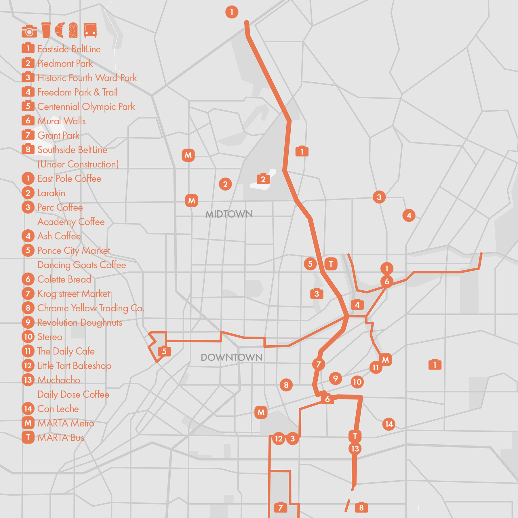
2. Southside Beltline & Grant Park
• Start & Finish: Boulevard trailhead to West End trailhead
• Route Profile: 3.3 miles one-way, 116 ft+, multi-use path with part of the trail unpaved
Partially unpaved and somewhat removed from Atlanta's urban core, the Southside BeltLine is the quietest section of the existing BeltLine trails, offering a tranquil experience that contrasts with the bustling, modern atmosphere of the Eastside BeltLine.
As of Spring 2024, the Southside BeltLine is closed between Boulevard SE and Glenwood Ave, where it connects to the Eastside BeltLine (Route #1). The section between Boulevard SE and Pittsburgh Yards is unpaved and may be closed for construction. West of Pittsburgh Yards, the trail is paved and transitions into the Westside BeltLine (Route #3) at Lee Street.
- Grant Park
Established in 1883, Grant Park is Atlanta’s oldest city park. Running in or around Grant Park is a great complement to the BeltLine routes. Nearby in the Summerhill neighborhood, Cheney Stadium, once a warm-up facility for track and field athletes during the 1996 Olympic Games, remains one of the few public tracks in Atlanta. Visitors to Atlanta should also check out the Olympic Cauldron Tower.
Run Clubs / @atltrailrunners meets at Grant Park Perc Coffee every Monday morning; @atlantarunclub hosts an easy recovery run from Peoples Town Coffee every Sunday at noon; Cheney Stadium is the default track workout location for Atlanta runners and run clubs.
Cafe / Little Tart Bakeshop, my favorite bakery in Atlanta, has two beautiful cafes located west and north of Grant Park.
Transit / There isn’t direct MARTA Metro access to the Southside BeltLine, but several stations are located near Grant Park and connecting trails, such as the BeltLine and Freedom Park Trail.

3. Westside Beltline & Lionel Hampton Park
- Westside BeltLine
• Start & Finish: West End Rose Circle Park to Washington Park
• Route Profile: 2.5 miles one-way, 63 ft+, multi-use path
This 2.5-mile section is the main component of the Westside BeltLine. The paved path is separated from car traffic, providing a safe and scenic route. It is also known for its vibrant public art, featuring murals, sculptures, and installations that reflect the cultural diversity and creative spirit of Atlanta's west side.
To the south, Westside BeltLine transitions into the Southside BeltLine (Route #2) at Lee Street/Murphy Avenue. To the north, an extension project is underway between Washington Park and Donald Lee Hollowell Parkway. Further north, the BeltLine continues along Marietta Boulevard, with a connector leading to Downtown Atlanta, and another paved trail in Westside Park. All these additional trails are detailed in Route #7.
- Lionel Hampton-Beecher Hills Park & Trail
Another excellent running destination in this area is Lionel Hampton-Beecher Hills Park, located two miles west of the Westside BeltLine. The park features two paved paths and dirt trails surrounding them. The trail system can be accessed from three main points: Willis Mill Road to the north and south, and Westwood Avenue to the east (closest to the Westside BeltLine).
Cafe / Redeveloped from the West End community’s former "Warehouse Row," Lee + White has become a vibrant destination offering a variety of cafes, breweries, and shops.
Transit / The Westside BeltLine is conveniently accessible from MARTA's West End and Ashby stations, with additional bus routes also serving the area.

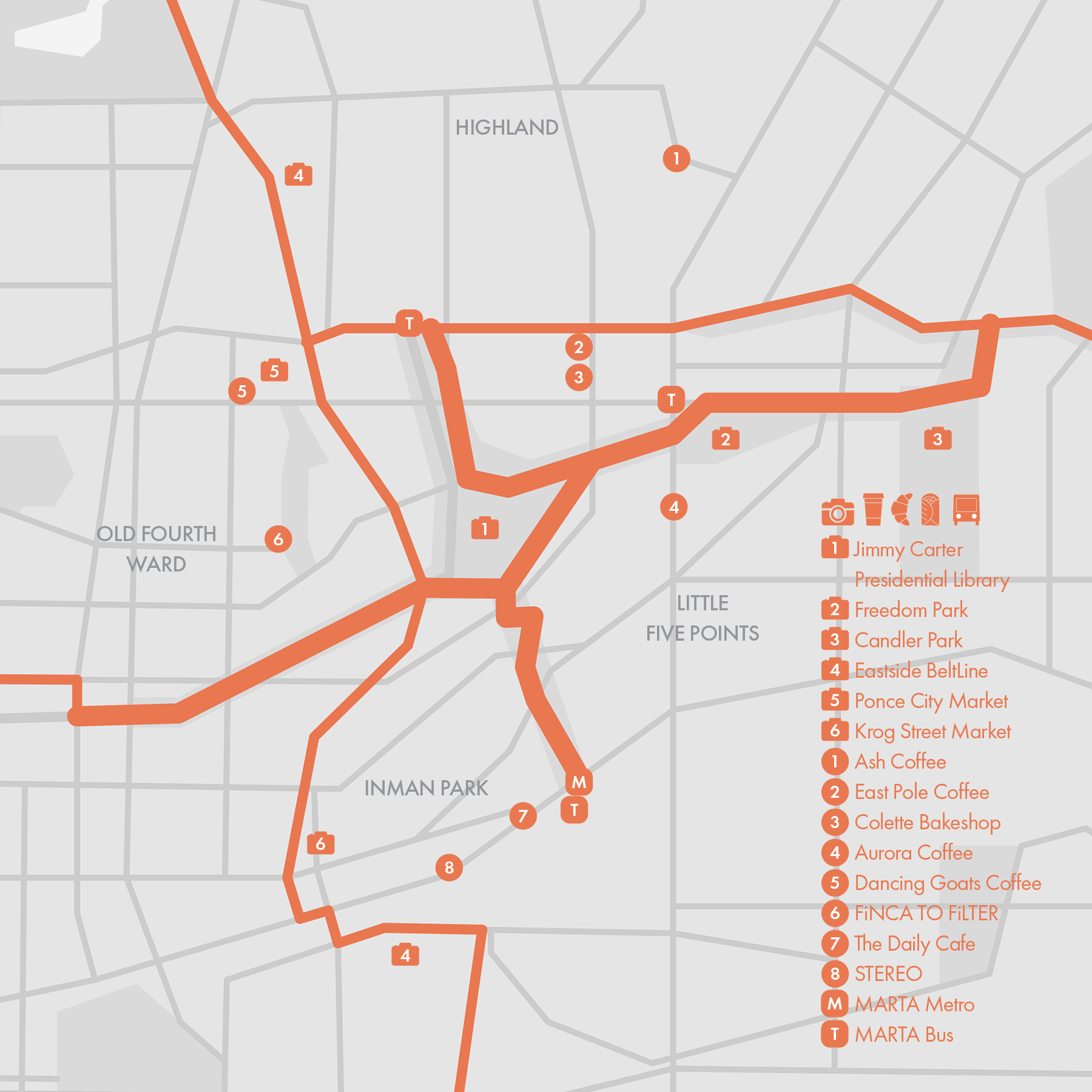
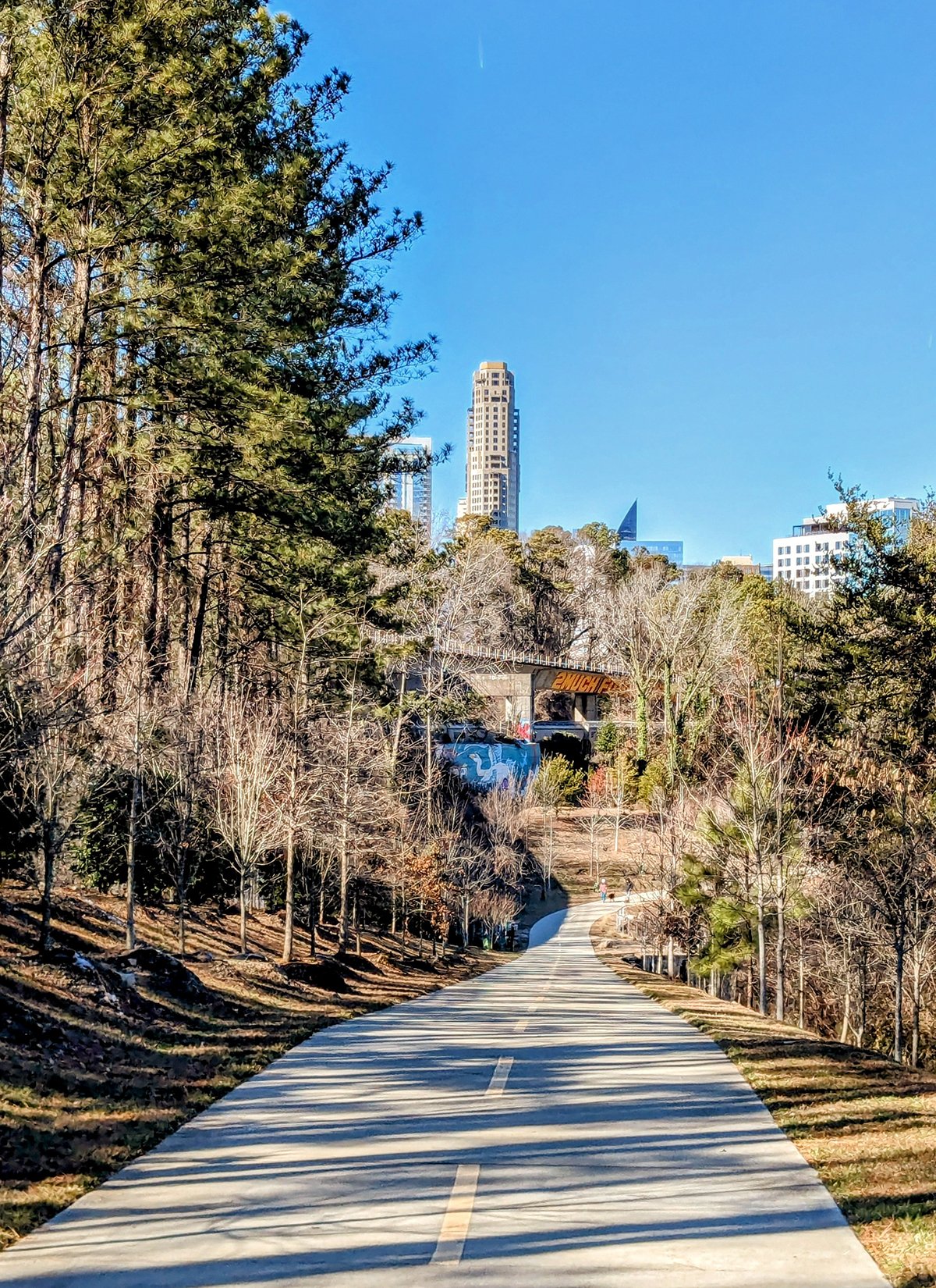
4. Freedom Park & Trail

Freedom Park is one of Atlanta's largest and most iconic green spaces, located in the city's east side. It spans over 200 acres and serves as a key connector between several vibrant neighborhoods, including Candler Park, Poncey-Highland, Inman Park, and the Old Fourth Ward. The park was created in the 1990s on land that was initially acquired for an expressway project that was eventually turned down by the local community. The park is known for its blend of natural beauty, public art installations, and historical significance.
• Start & Finish: Jackson St Bridge to Shady Side Park on Ponce De Leon Ave
• Route Profile: 2.82 miles one-way, 133 ft+, multi-use path, some street crossings
The main section of the Freedom Park Trail runs east-west along John Lewis Freedom Parkway and forms part of the 19-mile Stone Mountain Trail between Downtown Atlanta and Stone Mountain. The trail intersects with the Eastside BeltLine in the Old Fourth Ward, passes by the Jimmy Carter Presidential Library and Museum, and continues through Freedom Park. A series of sculptures line the trail between the Eastside BeltLine and Oakdale Rd, adding artistic interest to the scenic route.
The park features two connector trails: one branch to the north runs through the Poncey-Highland neighborhood, while another to the south meanders through the Inman Park neighborhood.
Run Clubs / Given its central location and great connectivity, Freedom Park Trail is one of the top running locations in the city. @atltrailrunners frequently run on Freedom Park Trail, both during their Wed PM run from Ponce City Market, and their Friday AM run from East Pole Coffee (my favorite!)
Cafe / Nestled between some of Atlanta's trendiest neighborhoods—Highland, Old Fourth Ward, and Inman Park—the trails are surrounded by a variety of coffee shops, bakeries, and cafes.
Transit / The southern end of the trail, in Inman Park, is accessible via the MARTA Blue Line. Ponce De Leon Avenue is served by relatively frequent bus routes, but beyond these, public transit options to the trails are limited.
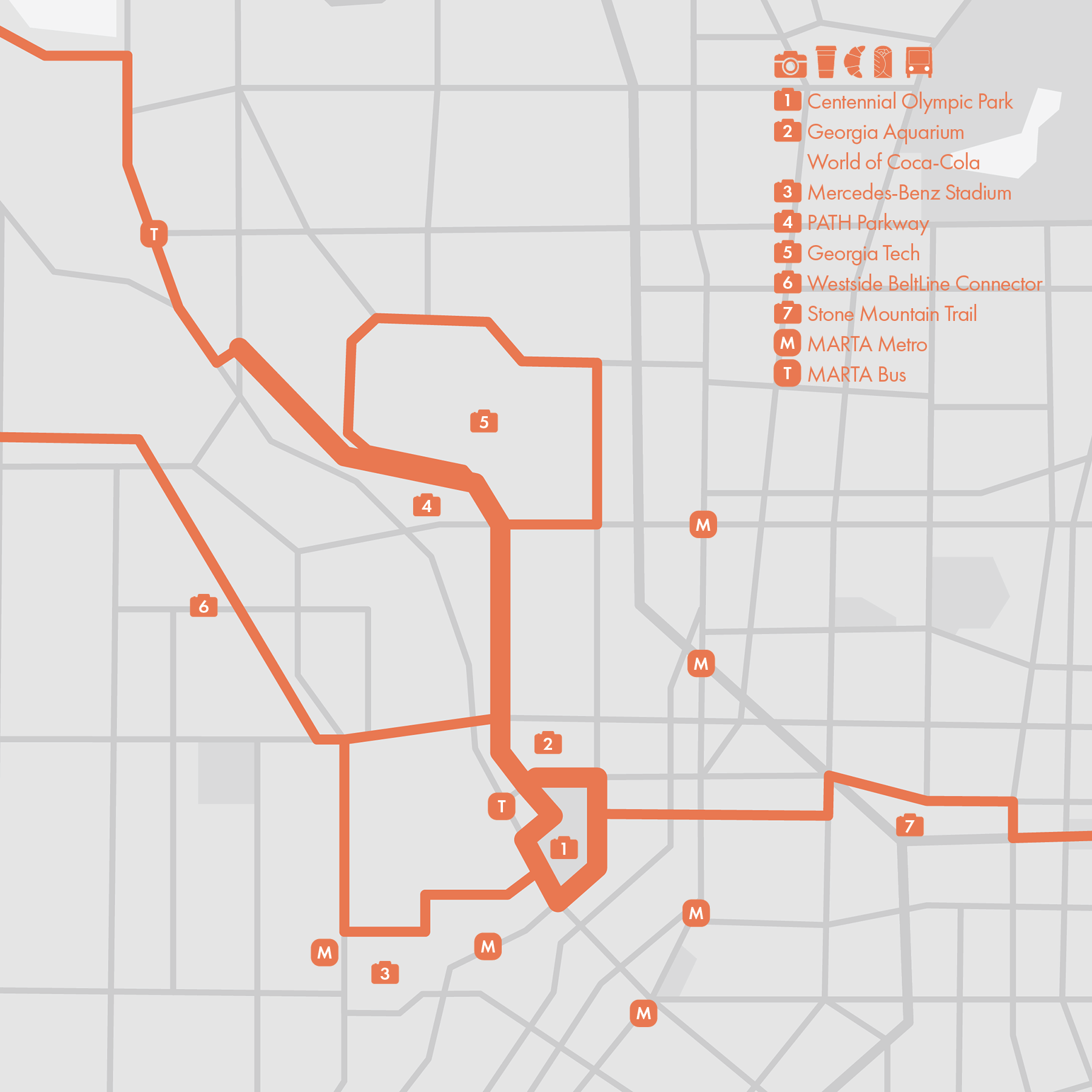
5. Centennial Olympic Park
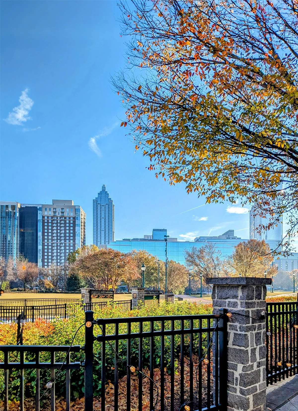
- Centennial Olympic Park
• Route Profile: 0.8 miles loop, 60 ft+, sidewalks
The 22-acre Centennial Olympic Park was built for the 1996 Summer Olympics and remains one of downtown's most popular destinations. It features the iconic Fountain of Rings, open green spaces, and hosts numerous events throughout the year. Centennial Olympic Park is centrally located near many of Atlanta's top attractions, including:
- Georgia Aquarium: One of the largest aquariums in the world, offering a vast array of marine life exhibits and interactive experiences.
- World of Coca-Cola: A museum dedicated to the history of the Coca-Cola Company, featuring exhibits on the brand's global impact and a tasting room with Coca-Cola products from around the world.
- National Center for Civil and Human Rights: A museum and cultural institution that explores the history of civil rights movements in the United States and around the world.
- Mercedes-Benz Stadium: Home to the Atlanta Falcons and Atlanta United, this state-of-the-art stadium is a short walk from the park.
Around Centennial Olympic Park there are three major trails:
- PATH Parkway
• Start & Finish: PATH Trailhead on Northside Dr & Hampton St to Centennnial Olympic Park
• Route Profile: 1.5 miles one way, 97 ft+, multi-use path
The PATH Parkway is a multi-use path that connects West Midtown, Georgia Tech Campus (P9-10) and Downtown Atlanta, providing easy and safe access to these areas for runners and cyclists.
- Westside BeltLine Connector (see Route #7): This trail links the Georgia Aquarium to the Westside BeltLine's Marietta section.
- Stone Mountain Trail: This 19-mile trail begins at Centennial Olympic Park, extends through Freedom Park (Route #4), Downtown Decatur (Route #6) and ultimately reaches Stone Mountain.
Cafe / Is it just me or there is simply no good coffee or cafe in Downtown Atlanta?
Transit / Downtown Atlanta is well-served by MARTA, with multiple train stations and bus routes making it easy to navigate the city. The Five Points Station is a major hub that connects all four MARTA rail lines.
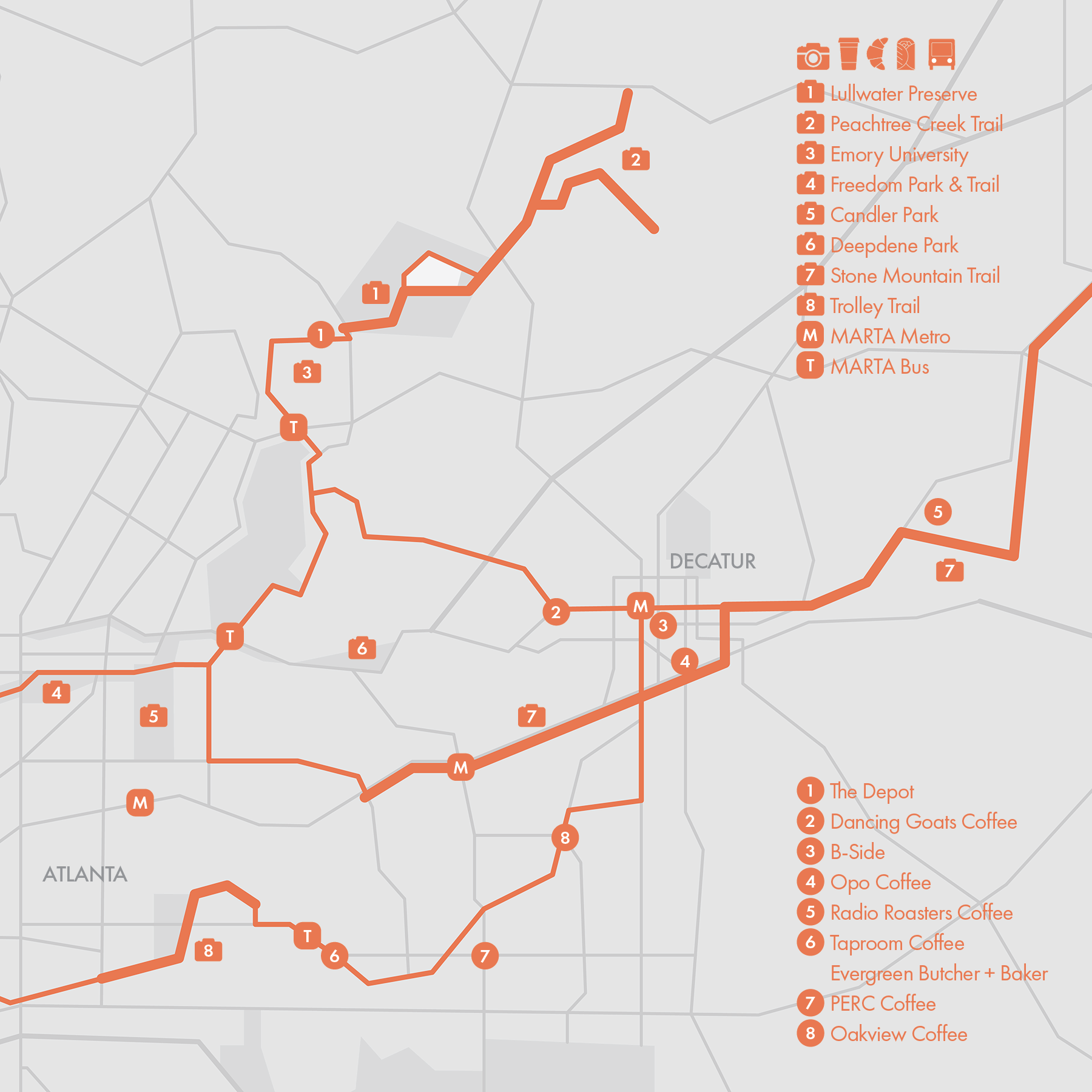
6. Eastside Trails
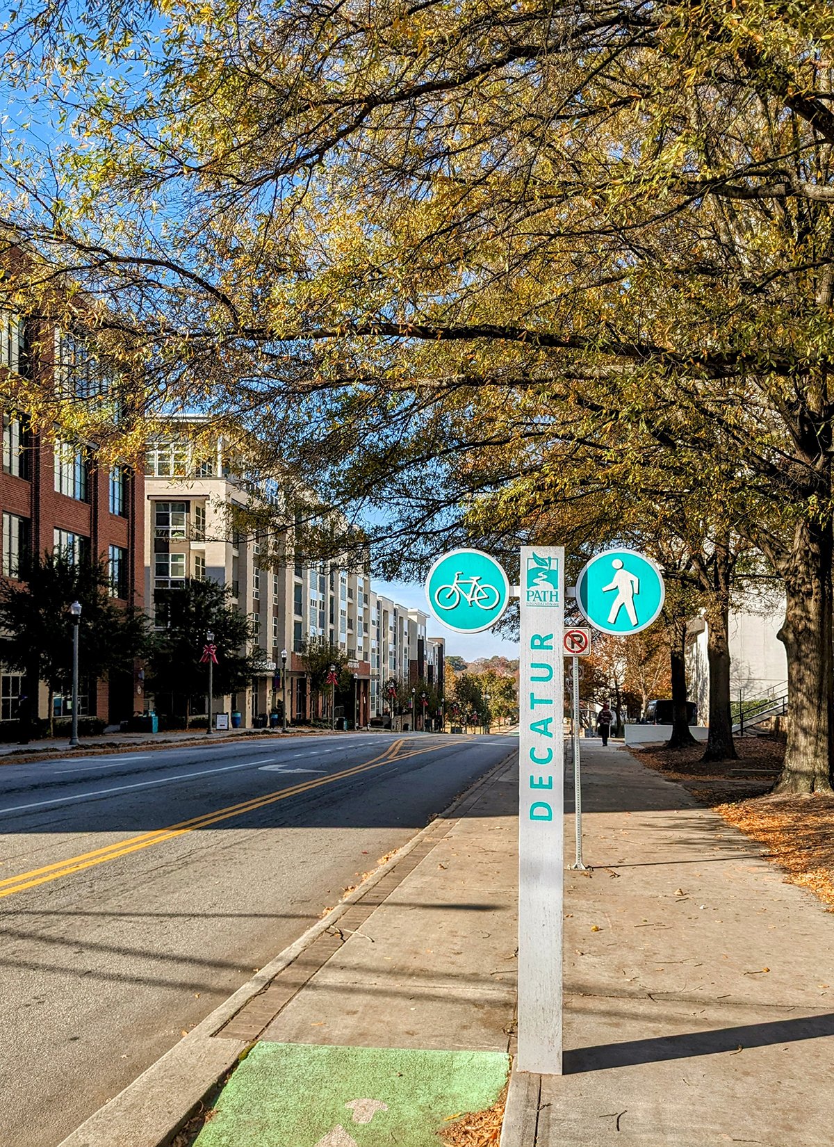
This guide highlights several paved, multi-use paths located on the east side of Atlanta. At the heart of these routes is Decatur, a key suburb in eastern Atlanta.
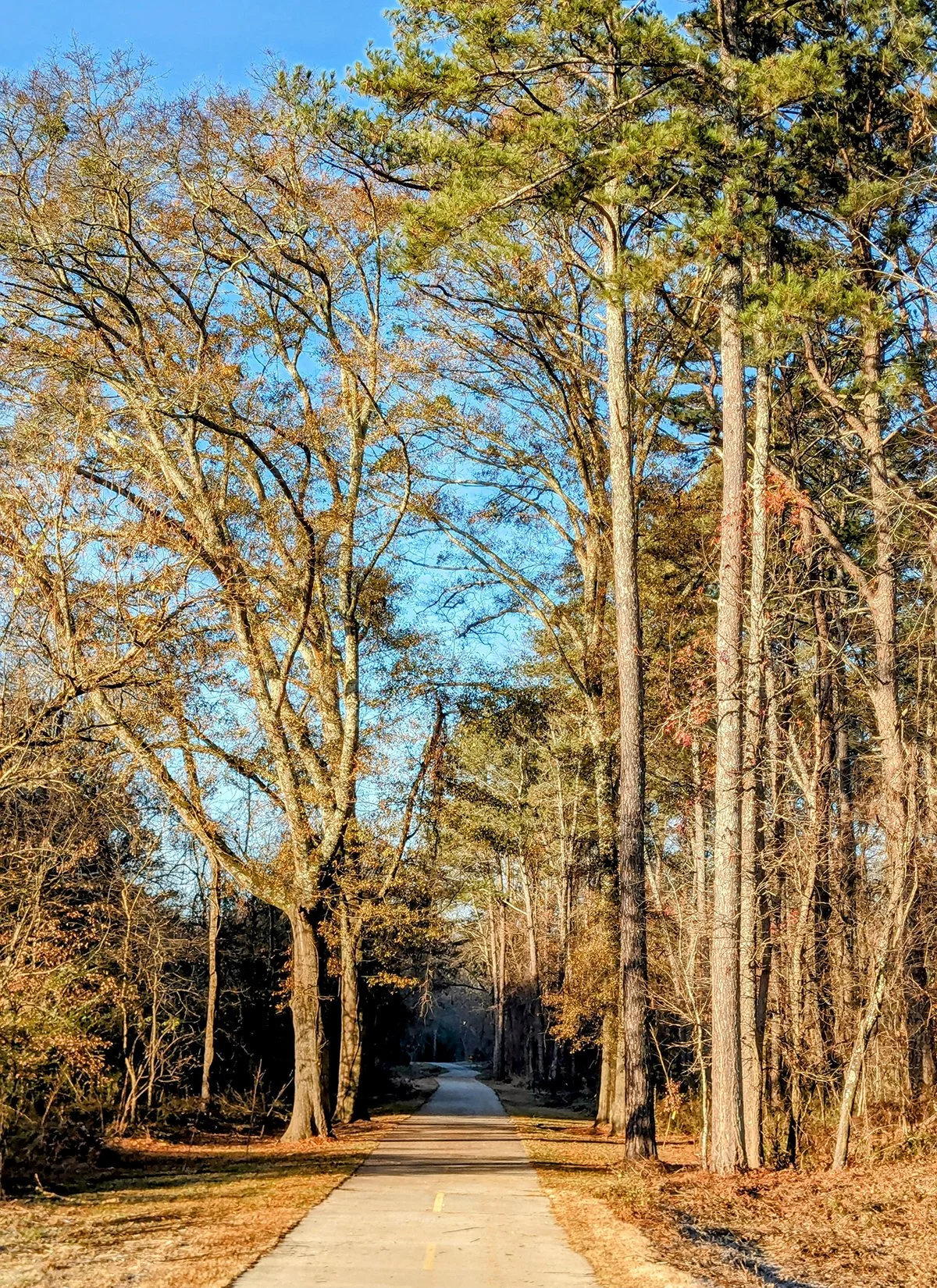
- Lullwater Preserve & Peachtree Creek Trail
• Start & Finish: Lullwater Preserve to Peachtree Creek Trail
• Route Profile: 2.4 miles one way, 148 ft+
Lullwater Preserve is a tranquil natural oasis located on the campus of Emory University, featuring several miles of well-maintained trails through lush forests and around a small lake.
The South Fork of Peachtree Creek runs through the preserve. An underpass beneath Clairmont Rd connects Lullwater Preserve with the Peachtree Creek Trail to the east. The trail has two branches: one passes by Mason Mill Park and ends at North Druid Hills Road, featuring a significant portion of boardwalk; and the other terminates in Medlock Park.
- Stone Mountain Trail
• Start & Finish: Dekalb Ave at McLendon Ave to Stone Mountain
• Route Profile: 12.5 miles one way, 530 ft+, rolling hills
The Stone Mountain Trail is a 19-mile multi-use path that extends from downtown Atlanta to Stone Mountain Park, winding through a variety of urban, suburban, and natural landscapes. For this guide, we focused on the section that follows Dekalb Ave from McLendon Ave to downtown Decatur, before continuing along Ponce de Leon Avenue towards Stone Mountain. This section consists of largely raise multi-use paths on the sidewalk.
- Trolley Trail
• Route Profile: 1.25 miles one way, 66 ft+
Though relatively short, the Trolley Trail is a valuable connector path linking the Eastside BeltLine to the quiet, charming neighborhoods of Kirkwood and East Lake in Atlanta.
Cafe / Stop by downtown Decatur to refuel your run at one of the many excellent coffee shops and cafes. Another great spot for coffee is the Kirkwood/East Lake area, where you’ll find Evergreen Bakery and PERC Coffee (where you'll find @atltrailrunners every Thursday morning.)
Transit / The MARTA Blue Line serves Downtown Decatur with additional stations along Dekalb Ave between Decatur and Atlanta.
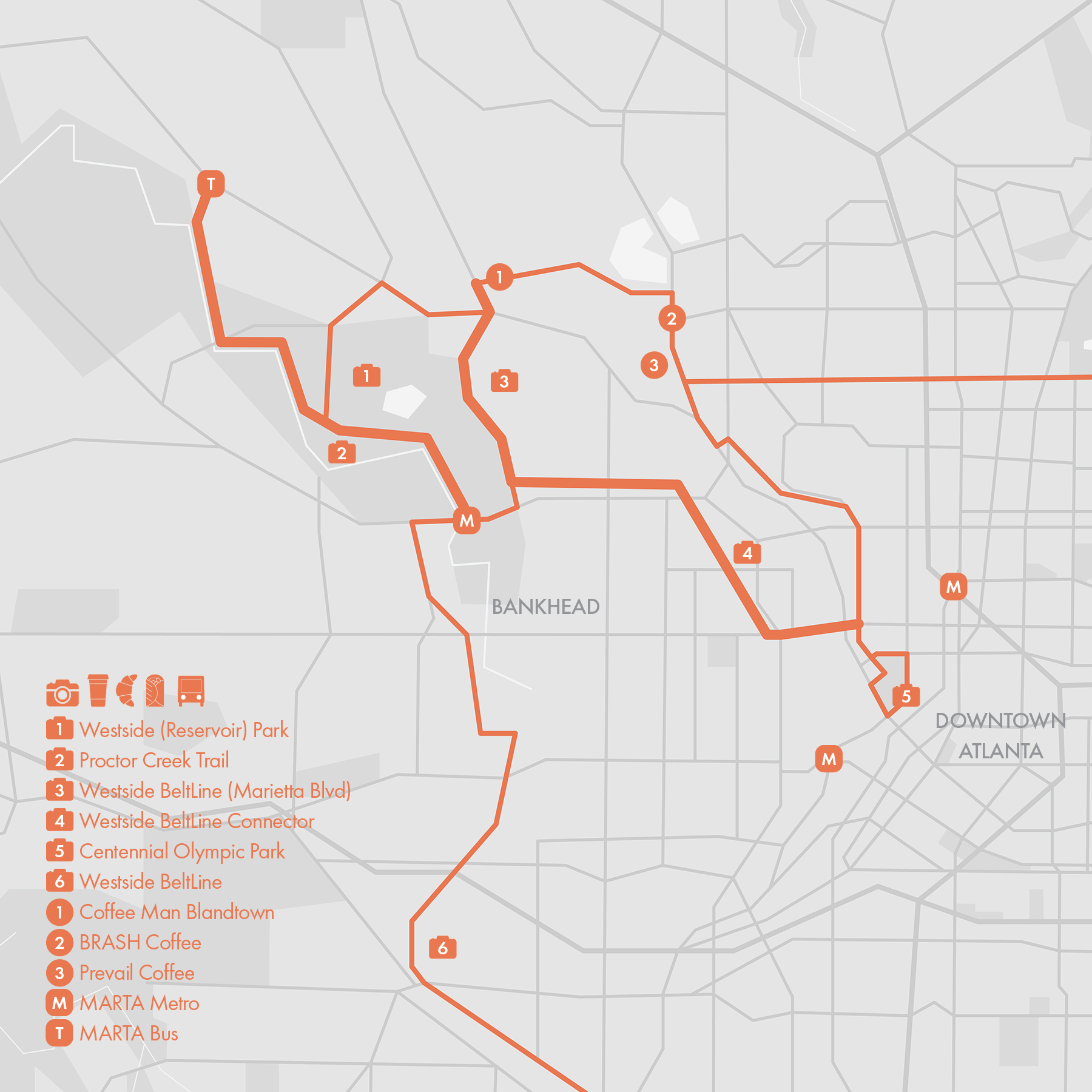
7. Westside Trails
This guide highlights three paved, multi-use paths located on the west side of Atlanta.
- Westside Park & Proctor Creek Trail
• Start & Finish: Bankhead MARTA, Proctor Creek Trailhead on Sanford Dr
• Route Profile: 2.45 miles one way, 75 ft+
Westside Park is Atlanta's largest green space, encompassing 280 acres on the site of the former Bellwood Quarry, a location with deep historical significance for the city. The quarry has been transformed into a massive reservoir, designed to serve as a backup water supply for Atlanta. Visitors can enjoy panoramic views of the quarry and the Atlanta skyline from an overlook platform. Proctor Creek runs through Westside Park, accompanied by a paved trail that connects the Bankhead MARTA Station to Perry Blvd.
- Westside BeltLine (Marietta Blvd)
• Start & Finish: Marietta Blvd between Huff Rd and Jefferson St.
• Route Profile: 1 mile one way, 79 ft+
This path runs along the wide sidewalk of Marietta Blvd. Although it is technically part of the Westside BeltLine, it remains disconnected from the main section of the Westside BeltLine further south.
- Westside BeltLine Connector
• Start & Finish: Marietta Blvd & Jefferson St, Ivan Allen Jr Blvd & Luckie St
• Route Profile: 1.9 miles one way, 72 ft+
This connector trail is a multi-use path that links the Marietta Blvd section of the Westside BeltLine with the Tech Parkway PATH and Centennial Olympic Park. The trail is separated from car traffic and intersects with only one city street, making it a safe and convenient route for pedestrians and cyclists.
Transit / The MARTA Green Line's Bankhead Station is conveniently located near Westside Park and the Proctor Creek Trail, and it's also close to the Marietta Blvd section of the Westside BeltLine and its connector trail. While buses serve this area, they are infrequent and often unreliable.
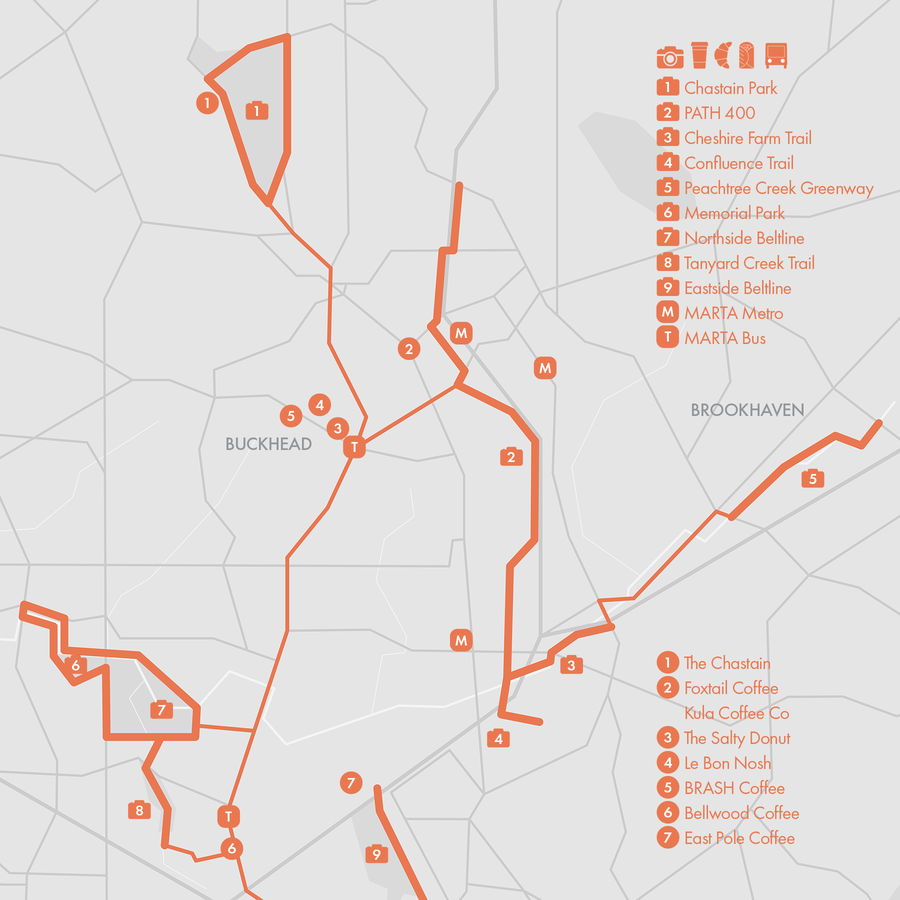
8. Northside Trails
This guide highlights several distinct paved, multi-use paths located on the north side of Atlanta. While part of the broader PATH network, these trails are largely disconnected from one another. At the heart of these routes is Buckhead (P3), a prominent and affluent neighborhood in northern Atlanta.
- Chastain Park Trail
• Start & Finish: anywhere along the loop
• Route Profile: 2.5 miles loop, 207 ft+
Chastain Park is one of Atlanta's largest and most popular public parks. This scenic route loops around the park, winding through wooded areas and open fields. For a longer route, you can extend the loop to 3 miles by including the area behind the amphitheater.
- PATH400
• Start & Finish: Trailheads on Piedmont Rd and Wieuca Rd
• Route Profile: 4.3 miles one way, 384 ft+
PATH400 is a multi-use path that runs parallel to Highway 400, cutting through the heart of Buckhead and offering serene pathways that are largely separated from car traffic. At the southern end, two short extension trails provide additional routes to explore.
- Peachtree Creek Greenway
• Start & Finish: Trailheads on Briarwood Rd and Druid Hills Rd
• Route Profile: 1.3 miles one way, mostly flat
Currently in Phase I, the Peachtree Creek Greenway runs along the North Fork of Peachtree Creek in Brookhaven, just northeast of Atlanta. This relatively new path features a wide, paved trail with scenic views and public art installations.
- Northside Beltline & Memorial Park
• Start & Finish: Trailheads on Briarwood Rd and Druid Hills Rd
• Route Profile: 3.84 miles loop, 151 ft+
This route loops around Atlanta Memorial Park and Bobby Jones Golf Course, incorporating segments of the Northside BeltLine. An additional scenic trail follows Tanyard Creek from the southern border of the golf course to Ardmore Park.
Transit / Buckhead, Lenox and Lindberg Metro Stations are located on the MARTA Red Line, connecting Downtown Atlanta, Midtown, and Buckhead. Additionally, Peachtree Road, a major thoroughfare in North Atlanta, is served by Bus Route 110, though service is unreliable.
9. Chattahoochee River Nat'l Rec Area
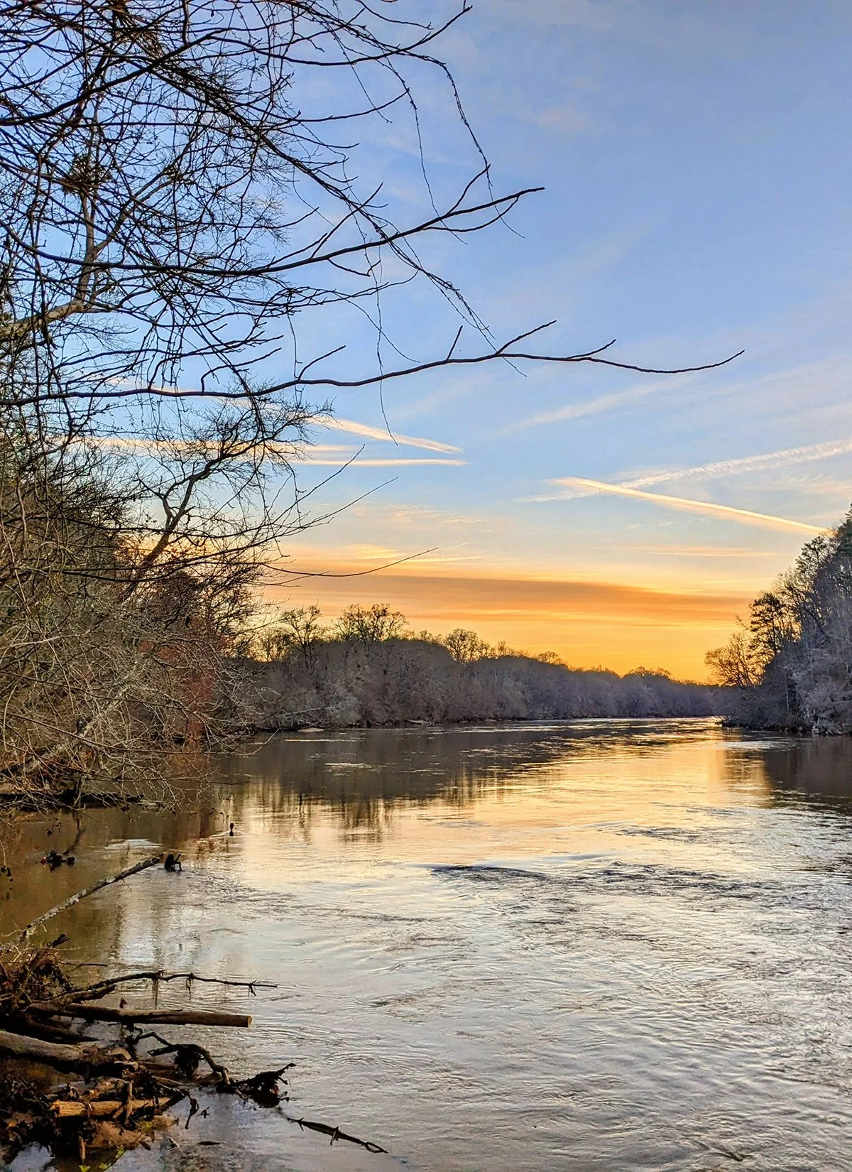
The Chattahoochee River National Recreation Area (CRNRA) comprises 15 separate land units along a 48-mile stretch of the Chattahoochee River. This guide focuses on two units (Cochran Shoals Unit and Paces Mill Unit) near Cumberland, where public transit connects to Atlanta.
- Cochran Shoals Trail
• Start & Finish: Cochran Shoals Trailhead off I-285
• Route Profile: 5 miles, 245 ft+, crushed gravel and dirt trail
This route forms a lollipop shape, starting and finishing at the trailhead off I-285. The out-and-back portion (P3) is mostly crushed gravel, while the loop section (P5) is a dirt trail with rolling hills and preset running directions. Driving is the easiest way to access the trailhead, but for those interested in reaching it on foot, it's about 2.5 miles from the Cumberland Transit Center via Akers Mill Rd and the Bob Callan Connector Trail. This route can be extended by adding the Sope Creek Loop at the north corner of the lollipop, which adds an additional 2.7 miles and approximately 280 ft+ to the course.
- Rottenwood Creek Trail / Bob Callan Trail
• Start & Finish: Paces Mill Unit off US-41, trailhead off Interstate N Parkway
• Route Profile: 3.2 miles, 192 ft+, paved
This urban, paved multi-use trail (P7-9) runs parralel to Rottenwood Creek on the east side of I-75. On the west side of I-75 is Cumberland, with multiple commercial centers such as Cumberland Mall, Akers Mill Square, and The Battery (P10). The south end of Rotten wood Creek Trail is in the Paces Mill Unit where additional trails, like the West Palisades Trail, are available. Additionally, as mentioned above, a connector trail links to Cochran Shoals Trail.
Transit / The Cumberland Transit Center serves as a hub for Cobb County's CobbLinc buses. These buses provide service to Smyrna and Marietta and offer a connection between Cobb County and Atlanta (Arts Center Station) via routes 10 and Rapid 10.

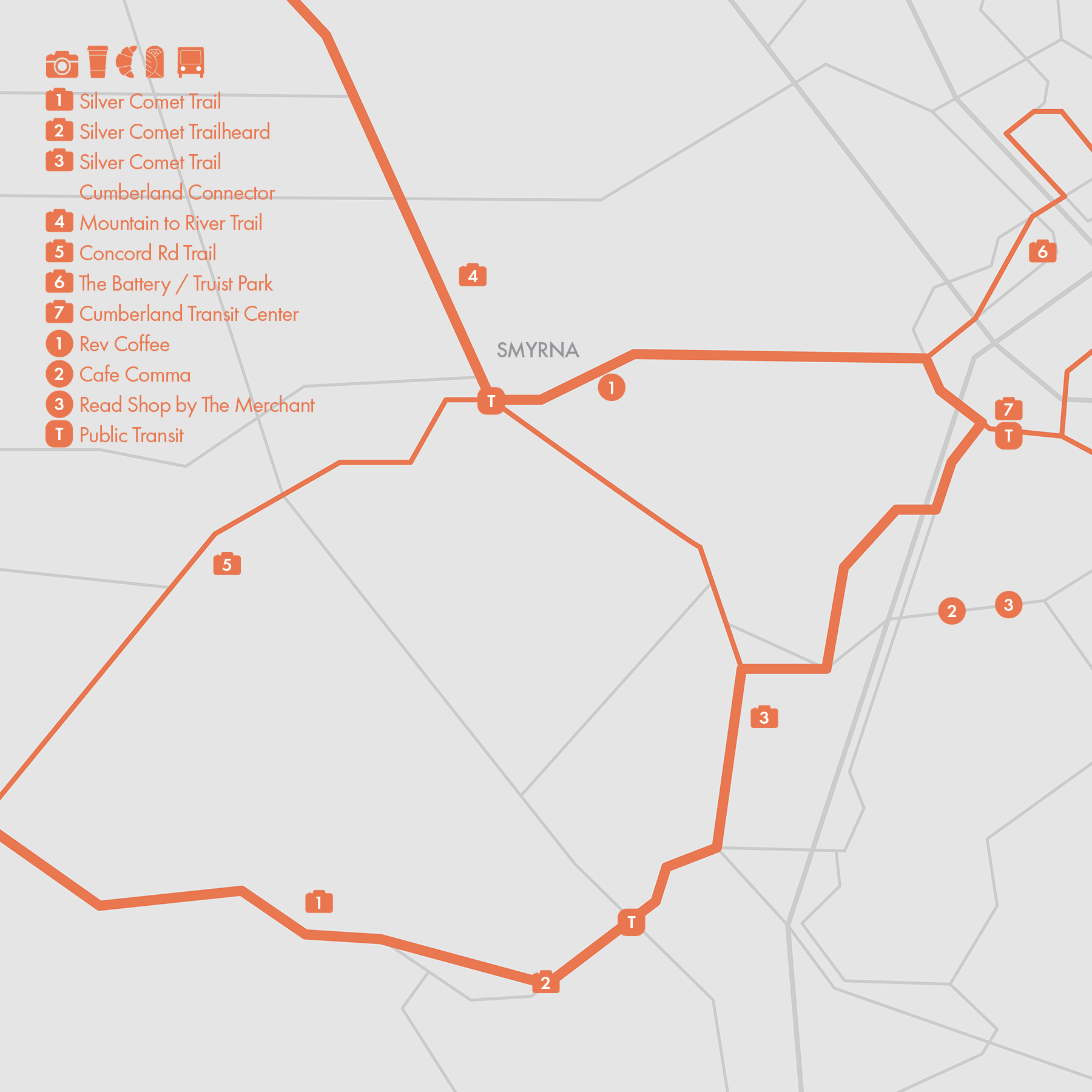
10. Silver Comet Trail
The Silver Comet Trail is a popular multi-use trail that begins in Smyrna, GA, near Atlanta, and stretches 62 miles westward to the Alabama state line. There, it meets the Chief Ladiga Trail, a 34-mile long multi-use path that extends from the Alabama-Georgia state line to Anniston, AL. The trail offers diverse scenery, ranging from suburban areas to scenic rural landscapes.
With its paved surface and multiple access points, the Silver Comet Trail is favored by runners and cyclists. Due to the lack of public transit in the area, runners typically drive to an access point and run out-and-back on the trail. Alternatively, they can link segments of the Silver Comet Trail with other local trails and streets.
The official start of the Silver Comet Trail is located at the end of Mavell Road in Smyrna, GA. A 4.7-mile connector trail links this trailhead to Cumberland, a vibrant area known for its blend of commercial, residential, and recreational amenities.
Also in this area is the Mountain to River (M2R) Trail, which connects Kennesaw Mountain National Battlefield Park to the Chattahoochee River. The 12.8-mile trail passes through Marietta and Smyrna and meets the Silver Comet Cumberland Connector near Cumberland Mall. The M2R Trail can also connect with the Silver Comet Trail via Concord Road.
Transit / The Cumberland Transit Center serves as a hub for Cobb County's CobbLinc buses. These buses provide service to Smyrna and Marietta and offer a connection between Cobb County and Atlanta (Arts Center Station) via routes 10 and Rapid 10.