Routes
The Twin Cities offer one of the most well-connected and scenic urban running infrastructures in the country, with Minneapolis and St. Paul each featuring a roughly 30-mile loop of parkways and trails. Minneapolis’s Grand Rounds links the Mississippi River, the Chain of Lakes, and numerous parks and natural areas. In addition, the Midtown Greenway provides a fast, protected east–west spine that connects the river to the lakes. Just outside the city, a network of regional trails in the western suburbs adds endless options for long, uninterrupted miles. Across the river in Saint Paul, a similarly scenic loop system, highlighted by the Sam Morgan Trail and loops around Lake Phalen and Como Lake, traces the city’s bluffs, parks, and riverfront. Additional long-distance routes such as the Bruce Vento Trail and the Gateway State Trail extend deep into the suburbs, offering more mileage on quiet, green corridors. While road runners enjoy the excellent infrastructure of multi-use paths, local trail runners flock to regional parks like Theodore Wirth Park in Minneapolis and Battle Creek Park in Saint Paul, both of which blend wooded singletracks, ski trails, and rolling terrain just minutes from downtown.

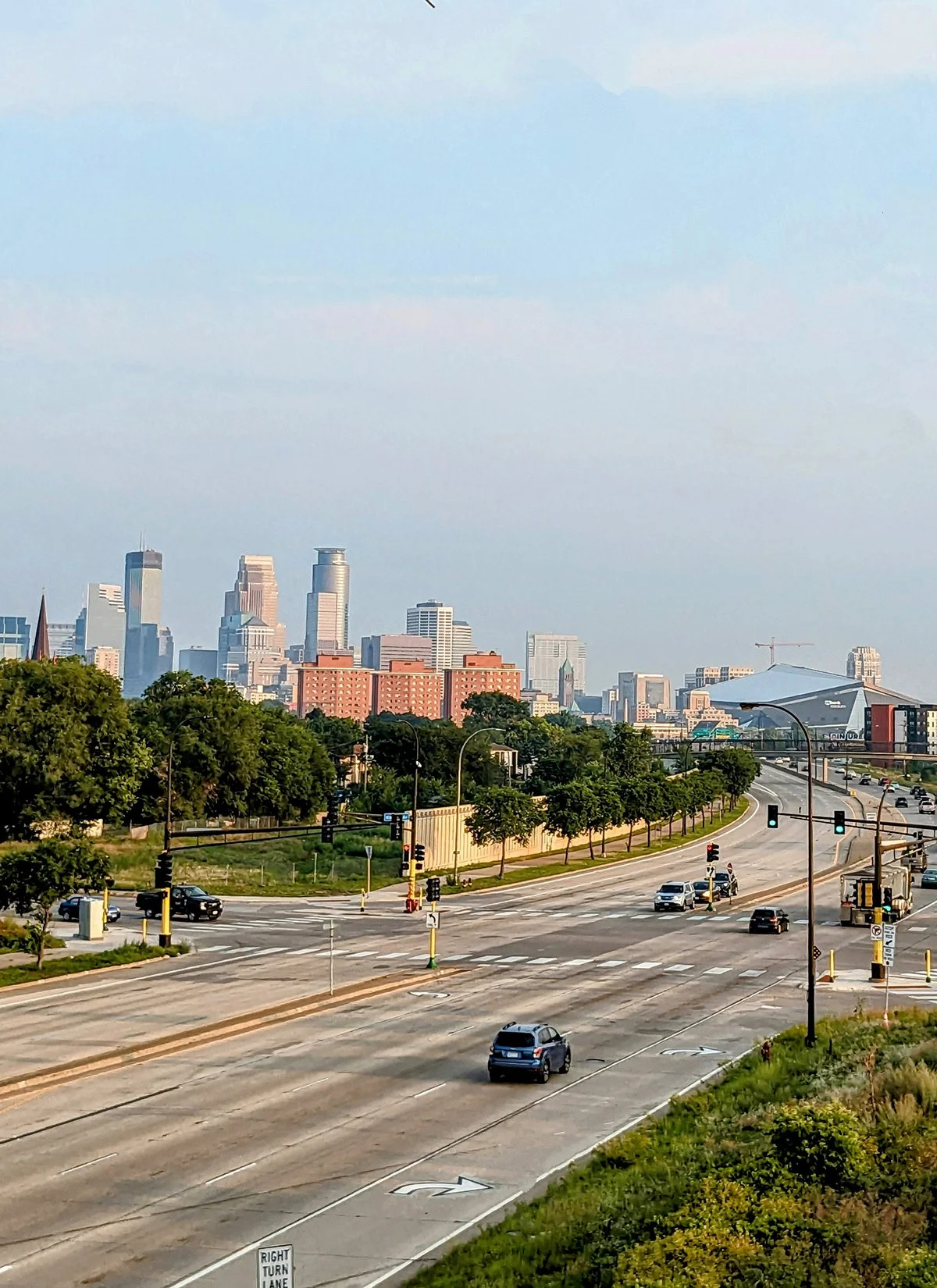
1. Downtown Riverfront

Minneapolis's downtown riverfront is a runner's paradise, featuring scenic trails on both sides of the Mississippi River. Eight bridges within a three-mile span connect these paths, offering endless running options. Instead of suggesting a specific route, here’s a list of places to explore along the downtown riverfront:
West Bank:
- Minneapolis' Downtown: a vibrant urban hub with rich cultural landmarks.
- Mill Ruins Park: Explore the remnants of Minneapolis’ historic flour milling industry.
- Gold Medal Park: A beautifully designed urban park named after the flour brand.
- Guthrie Theater: A cultural landmark that features striking architecture.
- Three major professional sports team stadiums: Target Field, Target Center, US Bank Stadium.
East Bank:
- St. Anthony Main: A charming historic district with cobblestone streets, dining, and entertainment options.
- Father Hennepin Bluff Park: Enjoy wooded trails and scenic vistas of the river and St. Anthony Falls.
- Boom Island Park: Another park featuring a marina, picnic areas, and walking trails.
- Mill City Running @millcityrunning : One of the best running stores and running communities in the country. Their weekly group runs is the best ways to explore the riverfront.
Bridges and Islands:
- Nicollet Island: A tranquil island with historic homes and scenic pathways.
- Broadway Bridge, Plymouth Bridge, Hennepin Bridge, Central Ave Bridge are three bridges with easy access to the trails.
- 10th Ave Bridge, Dinkytown Greenway Bridge, and UM Bridge require a detour from the riverfront trails.
- Last but not least, the iconic and historic pedestrian and bicycle bridge, Stone Arch Bridge (P10) offers breathtaking views of the river and skyline. It is currently closed due to renovation.
Cafes / There are an abundance of good cafes on both sides of the downtown riverfront.
Transit / On the west bank, Metro Transit light rails run along 5th St; Hennepin Ave, Nicollet Ave and Washington Ave are the main transit corridors. On the east bank, frequent bus services are on Hennepin Ave, Central Ave, and U

2. Mississippi River

• Start & Finish: anywhere along the loop
• Course Profile: 11.8 miles loop, 380 ft+, dedicated multi-use path, occasional street crossing
Running along the Mississippi River is one of the most iconic and accessible ways to explore and enjoy the city. Paved trails run along both sides of the river throughout the Twin Cities and extend into the suburbs. This particular route covers the section of the river trails between Bohemian Flats/UM in the north and Minnehaha Park/Ford Pkwy in the south. It seamlessly connects to the Downtown Riverfront section of the Grand Rounds (Route 1) and Minnehaha Park (Route 10).
On the west bank, the route follows W River Pkwy and is connected to the Midtown Greenway (Route 8). It also features an additional trail on the lower riverbank. The 3.2-mile Winchell Trail runs between E 24th St and E 44th St, with multiple access points along W River Pkwy.
On the east bank, the route follows E River Pkwy, with a short trail running on the lower riverbank from East River Flats Park. There are a couple of scenic overlooks along the trail, and a monument stands at the intersection of E River Pkwy and Summit Ave.
Along this route, five bridges connect the two riverbanks. The Franklin Bridge, Lake Street Bridge, and Ford Bridge can be accessed directly or via short ramps. The UM Bridge and the Dinkytown Greenway pedestrian bridge require short detours, as they do not have direct access to the trails.
Saint City Running @saintcityrunning is a couple blocks away from Ford Bridge. If you are in the area, definitely stop by the shop and join their Monday group runs along the river.
Both riverbanks are also part of the Twin Cities Marathon, which turns onto Summit Ave before finishing in front of the State Capitol in St. Paul.
Cafes / There aren't any cafes right on the riverfront trails, but there are many scattered in the neighborhoods along the river.
Transit / Metro Transit Blue and Green Line light rails have several stations within a mile from the riverbanks. For bus services, Franklin Ave, Lake St, and Ford Pkwy are the transit corridors.

3. Minnehaha Creek
In my opinion, Minneapolis has the best urban trail system, not only for its extensive mileage but also for its excellent connectivity. The Mississippi Riverfront (Route 2) and the Chain of Lakes (Route 4) are two most popular running spots in the city, and they are seamlessly connected by two other trails: the Midtown Greenway (Route 7) in the north, and the Minnehaha Creek Trail in the south.
Minnehaha Creek Trail
• Start & Finish: Lake Harriet South Beach, Minnehaha Falls Regional Park
• Course Profile: 5.75 miles one-way, mostly flat, dedicated multi-use path, some street crossings with traffic light
The Minnehaha Creek Trail runs along the meandering Minnehaha Creek between Lake Harriet (Route 4, P7) and Minnehaha Regional Park (Route 10), where the creek flows over Minnehaha Falls before entering the Mississippi River. Some sections of the trail feature a single path shared by walkers, runners, and cyclists, while other parts have separate walking and biking paths. There are also segments with multiple paths along the creek. Regardless, you'll be fine as long as you follow the creek. Cyclists on this trail tend to be understanding about runners on their path.
---
Lake Nokomis Loop
• Start & Finish: anywhere along the loop
• Course Profile: 2.85 miles loop, mostly flat, dedicated multi-use path
Lake Nokomis and Lake Hiawatha are two lakes located near the Minnehaha Creek Trail. Lake Hiawatha has a walking trail on just one side, but Lake Nokomis offers a scenic loop, making it an excellent spot for running on its own or as an add-on for those on the Minnehaha Creek Trail.
---
Both Minnehaha Pkwy and Lake Nokomis are on the Twin Cities Marathon course.
Cafes / Cafes are scattered throughout the neighborhoods that the trail traverses. While they are not directly on the trail, the walk to them is usually short and pleasant.
Transit / Along the trail, many intersecting streets are transit corridors with frequent service to Downtown Minneapolis, including Lyndale Ave, Chicago Ave, Bloomington Ave. Moreover, Light Rail Blue Line's 46 St Station is near the trail too.

4. Chain of Lakes

The Chain of Lakes is a series of urban lakes connected by parkways in southwest Minneapolis. The scenic, well-connected and largely uninterrupted trail network is one of my all-time favorite places to run.
The chain of lakes consists of five lakes:
- Bde Maka Ska: the largest of the five lakes, Bde Maka Ska means "White Earth Lake" in the Dakota language. The lake features a 3.1-mile loop. Bde Maka Ska and Lake Harriet are connected by William Berry Parkway, a half-mile stretch featuring the only small hill and the only traffic light and street crossing along the lakes.
- Lake Harriet: features a 2.8-mile loop, a bandshell with live music during the summer, and two public beaches. Located at the northeast corner of the park is the Lyndale Park, which boasts beautiful gardens and fountains. The south side of the lake is connected to Minnehaha Creek Trail (Route 3).
- Lake of the Isles: this irregular shaped lake features a 2.65-mile loop, two islands, and Kenwood Park at its north tip. Lake of the Isles and Bde Maka Ska are connected by a quarter-mile path that goes under the Midtown Greenway (Route 8) and Lake St.
Running along these three lakes makes a perfect 10-mile loop.
- Cedar Lake: a 1.7-mile trail runs along Cedar Lake Pkwy on the west side of the lake, connecting Theodore Wirth Pkwy (Route 5), North Cedar Lake Trail (Route 11), and Dean Pkwy, which is the gateway to South Cedar Lake Trail (Route 11), the Midtown Greenway (Route 8), Lake of the Isles, and Bde Maka Ska.
- Brownie Lake: the smallest lake of the chain, Brownie Lake has a one-mile loop of dirt trail, accessible from the north off Theodore Wirth Pkwy.
The chain of lakes is a major part of the Twin Cities Marathon and City of Lakes Half Marathon.
Cafes / Great cafes are plentiful around the lakes, particularly in the Uptown neighborhood. One of my all-time favorites is Black Walnut Bakery near Bde Maka Ska.
Transit / While this area doesn't have a light rail, bus routes 4, 6, and 17 provide frequent service between the lakes and Downtown Minneapolis.

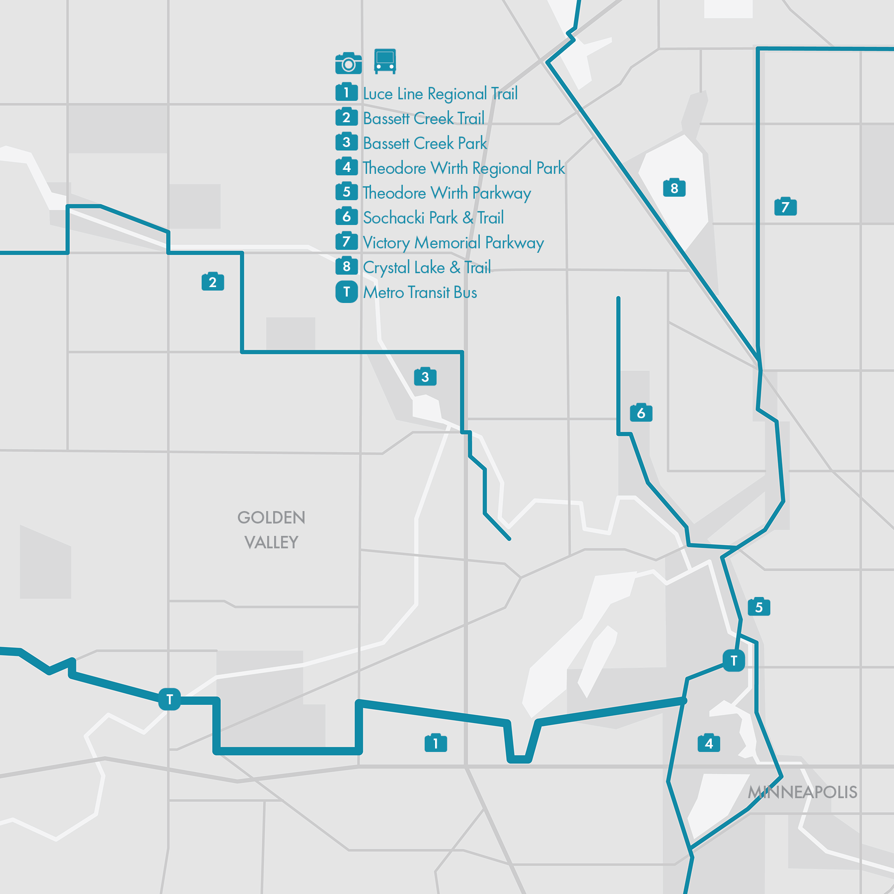
5. Theodore Wirth Park

• Start & Finish: Theodore Wirth Pkwy, from Broadway to I-394
• Course Profile: 3.6 miles one way, 149 ft+, multi-use path
Spanning over 740 acres, Theodore Wirth Park is one of the largest parks in Minneapolis and accommodates a plethora of outdoor activities. Besides running, Theodore Wirth Park is a popular destination for cycling and mountain biking; water sports on Wirh Lake in the summer, as well as cross country skiing in the winter.
Our recommended route follows Theodore Wirth Parkway in the heart of the park. However, the running possibilities within the park extend well beyond the Parkway. You'll discover a myriad of scenic trails meandering through dense woodlands, open meadows, and along the tranquil shores of Wirth Lake. For those seeking a more adventurous run, explore the network of dirt trails around the Golf Course or Eloise Butler Wildflower Garden and Bird Sanctuary. Thirsty Thursday Theo Trail Runners (they are on Facebook) is a friendly trail running group that meets every Thursday at Utepils Brewing for some trail miles and post run beers.
There are several other notable trail connections in the area.
• To the north, the route is connected with the Victory Memorial section of the Grand Rounds (Route 6), and Crystal Lake Regional Trail.
• To the South, the route is connected with Cedar Lake Pkwy, which leads to Cedar Lake Trail (Route 11) and the Chain of Lakes section of the Grand Rounds (Route 4)
• Luce Line Regional Trail (Route 12) starts in Theodore Wirth Park, with the trailhead right on the parkway.
• There is a paved trail along Bassett Creek that connects Theodore Wirth Park and Bryn Mawr Park, the trailhead is on Glenwood Ave just outside the park. From Bryn Mawr Park, overpasses will help you get ontp Cedar Lake Trail.
• Sochacki Park, while modest in size, boasts lush greenery and a tranquil 1.5-mile paved path through the woods.
Cafes / Check out Misfit Coffee in the Bryn Mawr neighborhood.
Transit / There are several bus stops along the parkway, with Bus 7, 9 and 14 connecting different parts of the park with Downtown Minneapolis

6. Victory Memorial
• Start & Finish: Victory Memorial Pkwy at Broadway, Webber Pkwy at Lyndale Ave
• Course Profile: 3.3 miles one way, flat, dedicated multi-use path, infrequent street crossings
Victory Memorial Parkway is a historic and scenic parkway in Northwest Minneapolis, designed and named as a tribute to the Hennepin County soldiers who lost their lives in World War I. The boulevard style Parkway is shaped like an upside-down L shape, featuring an excellent multi-use walk/bike path separated from auto traffic by green belts on both sides.
To the south, the path seamlessly transitions into the Theodore Wirth Trail (P5) following a multi-street intersection at Broadway, making the border of the Theodore Wirth section of the Grand Rounds (Route 5). To the East, the path extends into Webber Park after crossing 45th Ave, and ends near the Mississippi River. Along the river is the North Mississippi Regional Park, and the Northeast section of the Grand Rounds is just across the river.
Besides this route, there are several other notable trails in the area.
• Shingle Creek Trail, as detailed in Route 13, is a scenic regional trail that winds along the creek northward to Palmer Park and beyond.
• Crystal Lake Trail and Twin Lakes Trail are located west of Victory Memorial, these two regional trails each span approximately 2 miles and offer serene lakefront views and provide options to connect with other trails to create a loop route.
• Sochacki Park, while modest in size, boasts lush greenery and a tranquil 1.5-mile paved path through the woods.
More over, Run Minnesota's annual Victory Races are held on this parkway.
Cafes / Though cafes may be sparse in this area, the Get Down Coffee Company is a great spot conveniently located near the path and Metro D Line.
Transit / Metro C and D Lines are frequent bus routes that connect this area with Downtown Minneapolis. Bus 14 is another frequent route serving this area, running along Broadway.
7. Northeast Minneapolis

• Start & Finish: Camden Bridge, Stinson Pkwy at Como Ave
• Course Profile: 5.5 miles one way, 240 ft+, raised multi-use path on city streets
Northeast Minneapolis is a dynamic and culturally rich area known for its historic charm, artistic community, and vibrant neighborhoods. It is regarded as a highly livable and desirable area, particularly renowned for its thriving arts scene.
The Northeast section of the Grand Rounds is a raised bike path that follows St. Anthony Pkwy/Blvd and Stinson Pkwy from the Mississippi riverfront to Hillside Cemetery. The start of this route is connected to the Victory Memorial section of the Grand Rounds (Route 6). The end of this route is a little over a mile away from the Mississippi River, where you'll find the Downtown Riverfront and Mississippi River sections of the Ground Rounds (Route 1 and 2).
Besides this route, there are several other notable trails in the area.
• Columbia Park, which the route passes through, has a 2.25-mile paved loop, complete with a challenging hill at its northeast corner.
• The Diagonal Trail, a serene 1.5-mile pathway bordering Hillside Cemetery, offers a tranquil retreat, wholly detached from car traffic.
• Ridgeway Pkwy, also tracing along Hillside Cemetery, features an excellent vista of the Minneapolis skyline.
• Silver Lake is another gem in Nordeast, offering a scenic 2-mile loop seamlessly connected to Stinson Blvd NE.
• Great Northern Greenway, a raised bike path running along NE 18th Ave (except for an interruption around Monroe St NE), serves as a vital link between the Mississippi River Pkwy and the Diagonal Trail.
• Dinkytown Greenway, though short, is an important connector between the river and UM Track, which is open to the public.
Cafes / Some of my favorite cafes in Northeast include Marty's Deli (great sandwiches), The Briar (great coffee and vibes), Dogwood Coffee (great space) and Al's Breakfast, a 14-seat, cash-only institution of the city.
Transit / There are bus stops along the majority of this route and all the buses go to Downtown Minneapolis.
8. Midtown Greenway

• Start & Finish: Midtown Greenway end to end, from W River Pkwy to Dean Pkwy
• Course Profile: 5.5 miles one way, mostly flat, paved
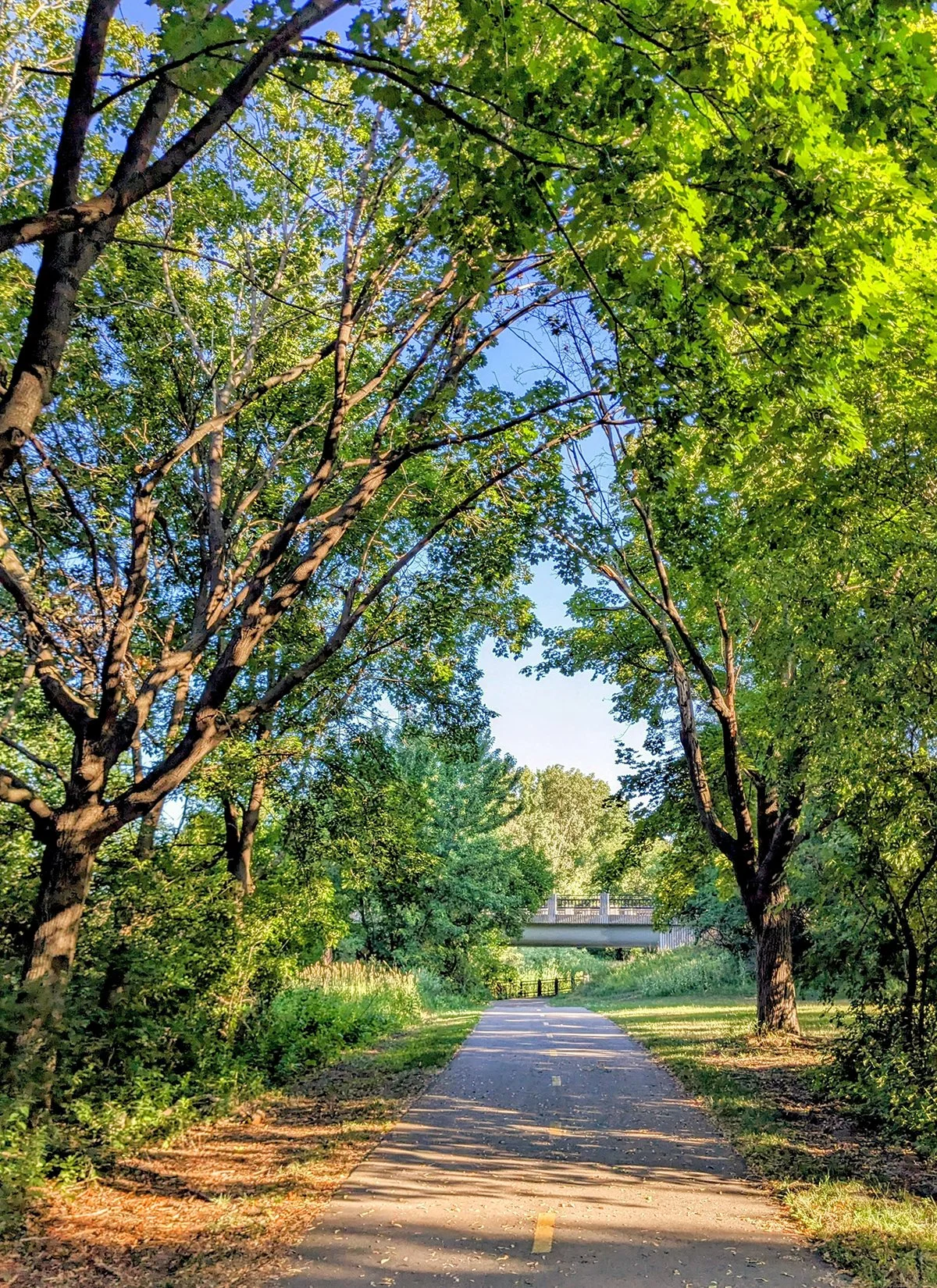
The Midtown Greenway is a vibrant walking and cycling trail running east-west through the heart of Minneapolis, tracing its path along a former railroad corridor. A significant portion of the trail, particularly west of Hiawatha Ave, is grade-separated from city streets, passing beneath bridges that carry street traffic. The Greenway opens 24/7, it is plowed in the winter and lit at night, offering a fantastic uninterrupted experience to across the city on foot or bike.
Midtown Greenway is one of my favorite running routes in Minneapolis, especially for tempo runs, because it's mostly flat and uninterrupted, with easy connections to other great running routes on both ends. Moreover, while the trail is usually quiet and calm, it is one block away from Lake St, where both dining and transit options are plenty.
• More running options:
- On the east end, the route meets the Mississippi River Parkway (Route 2)
- On the west end, the route can seamlessly transition to the Chain of Lakes (route 4) and the south branch of Cedar Lake Trail (Route 11)
- The route intersects with the Hiawatha LRT Trail (Route 9)
Cafes / There is no shortage of cafes and eateries along Midtown Greenway, including food courts in Midtown Global Market and Eat Street on Nicollet St. Two of my favorite bakeries are a short walk away from the Greenway too: Laune Bread near the river, and Black Walnut Bakery near the lakes.
Transit / Midtown Greenway runs parallel to Lake St, which is a bus corridor with frequent service of Bus Route 21 (the future Metro B Line). Along Lake St, major transfer points include Uptown Transit Center for multiple buses, Highway 35 for Metro Orange Line, Chicago Ave for Metro D Line, and Hiawatha Ave for Metro Light Rail Blue Line, all of which go to Downtown Minneapolis.

9. Hiawatha LRT Trail
• Start & Finish: U.S. Bank Stadium, Minnehaha Regional Park
• Course Profile: 4.86 miles one way, mostly flat, paved
This route runs along the Metro Transit Blue Line LRT corridor. It extends diagonally from Downtown Minneapolis at 3rd St near the U.S. Bank Stadium to Minnehaha Pkwy (48th St) near Minnehaha Regional Park. The entire path is paved and shared between walkers and cyclists.
From the U.S. Bank Stadium to the intersection with Midtown Greenway near 28th St, the trail is separated from city streets, ensuring a safe and uninterrupted journey. South of 28th St, the trail transitions to a raised path on the sidewalk of Hiawatha Ave, with several street crossings along the way.
Overall the Hiawatha LRT Trail is urban and not particularly scenic, it is, however, centrally located and transit friendly.
• More running options:
- On the north end, the route terminates a few blocks away from the Mississippi and can be linked up with with Downtown Riverfront (Route 1)
- On the south end, the route is connected to Minnehaha Creek Trail (route 3) and Minnehaha Regional Park (Route 10)
- The route intersects with Midtown Greenway (Route 8)
Transit / Since the trail runs along the Light Rail Blue Line, there are light rail stations on the route every half to one mile. All of these stations offer transfers to bus routes; in particular, Route 21 at Lake St station and Metro A Line at 46th St station are two frequent bus services.

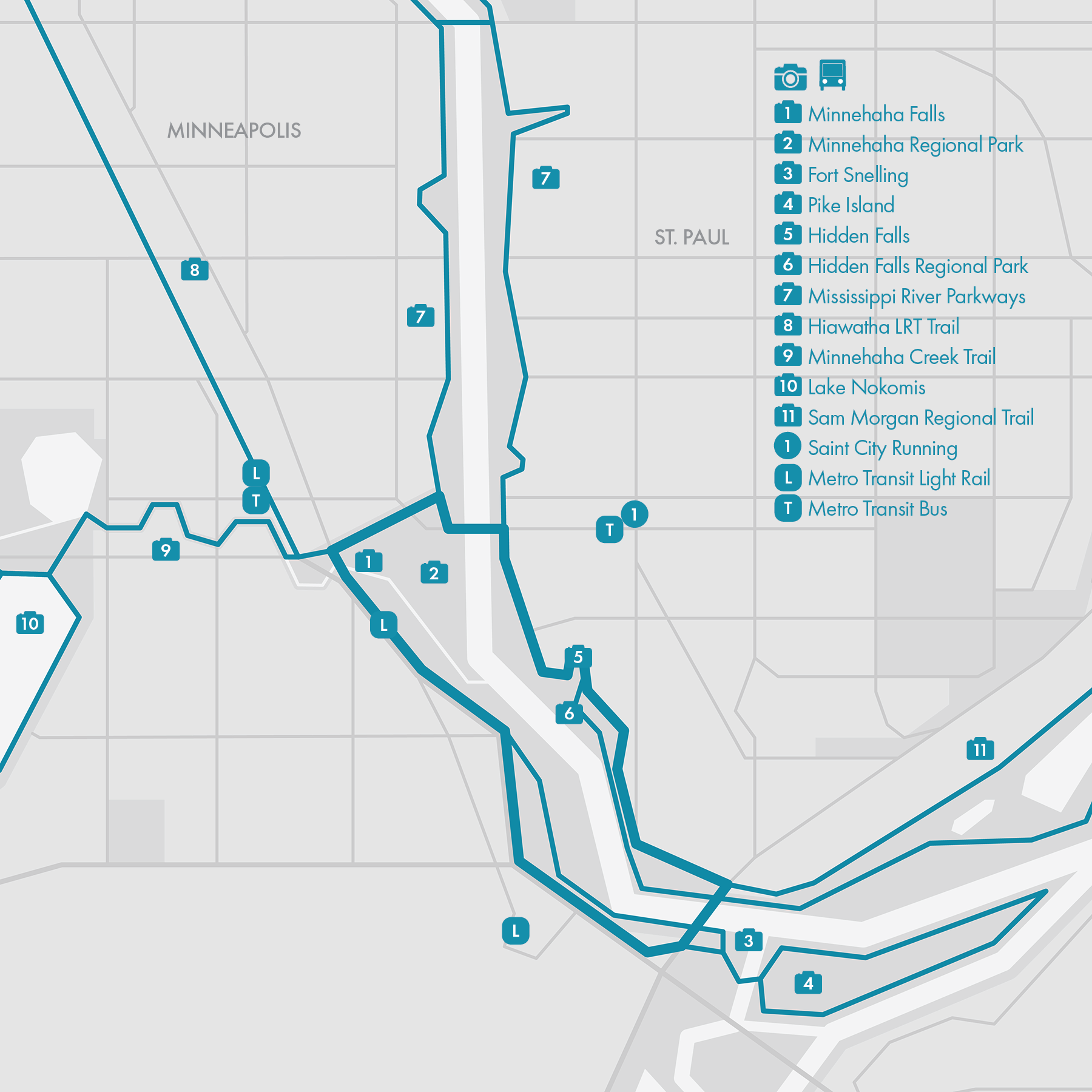
10. Minnehaha Falls - Hidden Falls

• Start & Finish: Minnehaha Falls
• Course Profile: 6 miles loop, 175 ft+, multi-use, paved
This route explores two scenic regional parks: Minnehaha Falls Regional Park in Minneapolis, located on the west bank of the Mississippi River, and Hidden Falls Regional Park in St. Paul, situated on the east bank. These parks are linked by two bridges spanning the river: the Ford Pkwy Bridge to the north and the Hwy 5 Bridge to the south.
The centerpiece of Minnehaha Regional Park is the Minnehaha Falls (cover, video), which plunges 53ft (16m) over a limestone cliff into the gorge below. South of the Minnehaha Regional Park, Historic Fort Snelling overlooks the confluence of Minnesota River and Mississippi River. This route follows a paved path that connects the falls and the fort, with a staircase down to the Hwy 5 Bridge; Minnehaha Trail is an alternative trail that runs closer to the river and goes under the Hwy 5 Bridge to the back of Fort Snelling.
On the other side of the Mississippi, this route follows the paved path next to the Mississippi River Parkway, again with a staircase providing access to the Hwy 5 Bridge. En route, a few scenic overlooks dot the parkway, and the Hidden Falls concealed beneath a sharp turn. Hidden Falls Regional Park lies on the lower grounds along the path, offering a tranquil sand beach and additional trails that are accessible when water levels are low.
• More running options:
- On the Minneapolis side, this route seamlessly integrates with Mississippi River Parkways (Route 2), Minnehaha Creek Trail (Route 3) and Hiawatha LRT Trail (Route 9).
- From Fort Snelling, runners can also cross the Minnesota River to Mendota (Route 15), or explore Pike Island and Fort Snelling State Park.
- On the St. Paul side, this route is connected with the Mississippi River Parkways (Route 2) and Sam Morgan Regional Trail (Route 14).
Transit / Light Rail Blue Line runs along the west edge of the Minnehaha Regional Park. 46th St light rail station is also a bus hub with multiple bus routes going to both Minneapolis and St. Paul.
11. Cedar Lake Trail

The Cedar Lake Trail consists of three sections: the North Branch runs north of Cedar Lake, beginning near Dunwoody Blvd close to the Sculpture Garden and stretching all the way to Hopkins Depot. The South Branch winds its way south of Cedar Lake, commencing at the west end of the Midtown Greenway and also terminating at Hopkins Depot, where it meets the North Branch. While some sections of the South Branch trail may be closed due to ongoing light rail construction nearby and require occasional detours, the Cedar Lake Trail remains a popular running destination.
North Cedar Lake Trail
• Start & Finish: Dunwoody Blvd, Hopkins Depot
• Course Profile: 6.85 miles one way, 130 ft+, multi-use, paved
South Cedar Lake Trail
• Start & Finish: Dean Pkwy, Hopkins Depot
• Course Profile: 4.75 miles one way, 115 ft+, multi-use, paved
The third part of the Cedar Lake Trail is the Downtown Connector, linking the Mississippi River Parkway to the North Branch Cedar Lake Trail. Currently, this connector extends only to Glenwood Blvd, requiring a detour between Glenwood Blvd and Dunwoody Blvd.
• More running options:
- To the west, Cedar Lake Trail extends to Hopkins, serving as a gateway to a network of regional trails. From there, runners can easily transition to the Lake Minnetonka Regional Trail, Minnesota River Bluffs Regional Trail, and Nine Mile Creek Regional Trail (Route #20).
- On the eastern side, Cedar Lake Trail offers seamless connectivity to the Minneapolis Grand Round, opening up a myriad of running possibilities. Runners can explore iconic destinations such as the Chain of Lakes (Route #4), Theodore Wirth Park (Route #5), and Midtown Greenway (Route #8).
Cafe / A few good bakeries can be found near the east end of Cedar Lake Trail, including Rustica, Honey & rye, and Black Walnut Bakery.
Transit / The area along the Cedar Lake Trail is served by two Metro Transit bus routes: Bus 17 (Minnetonka Blvd) and Bus 612 (Excelsior Blvd).
Hopkins Depot is slated to serve as a future light rail station for the Metro Transit Green Line extension, connecting the area with both Minneapolis and St. Paul.


12. Luce Line Trail & Medicine Lake

Luce Line Trail
• Start & Finish: Theodore Wirth Reguonal Park, Downtown Wayzata
• Course Profile: 11 miles one way, 367 ft+, multi-use, mostly paved.
The Luce Line Regional Trail is a multi-use path that starts in Theodore Wirth Park in Minneapolis and runs westward along the former Luce Line Railroad. 9 miles later it becomes Luce Line State Trail in Plymouth, MN and continues 63 miles to Thompson Lake near Cosmos, MN.
This route covers the 9-mile paved Regional Trail and goes one mile further west, before turning south and finishing at the lakefront of Wayzata Downtown (outside the maps). For the most part, it closely follows the railroad tracks, with the exception of a detour around Golden Valley Country Club. The route traverses a mix of residential, industrial, and natural areas.
---
Medicine Lake Loop
• Start & Finish: East Medicine Lake Park
• Course Profile: 7.5 miles loop, 300 ft+, multi-use on the east side, sidewalks on the west side.
Located 5 miles west of Theodore Wirth Park is the expansive 902-acre Medicine Lake. Encircling this tranquil body of water and the French Regional Park on the north shore of the lake is a 7.5-mile loop trail, which shares 1 mile with the Luce Line Trail.
---
• More running options:
- Theodore Wirth Park has an excellent trail system (both paved paths and single-rack dirt trail), and is part of the Minneapolis Grand Round.
- Bassett Creek Trail is a less visited trail and can be used to connect Medicine Lake and Theodore Wirth Park to form a loop if you don't want to go out-and-back on Luce Line Trail.
- While this suggested route ends in Wayzata, one can continue on the Luce Line State Trail (like, forever), or switch to the paved and scenic Dakota Rail Trail at Wayzata Downtown.
Transit / There are several express bus routes connecting this region with Downtown Minneapolis. Route and schedule info can be found on Metro Transit website.

13. Shingle Creek Regional Trail
• Start & Finish: Webber Park, Brookdale Park
• Course Profile: 7.7 miles one way, 126 ft+, multi-use paths, mostly paved
Shingle Creek Regional Trail is a scenic urban trail that winds its way through the cities of Brooklyn Center and Brooklyn Park, both suburbs located to the north of Minneapolis.
The trail starts at Webber Park on the Minneapolis Grand Rounds (Route #1-7), situated between Victory Memorial Parkway and the Mississippi River. Following the flow of Shingle Creek northward, the trail meanders through quiet suburban landscape, weaving its way through a series of parks, including Shingle Creek Park, Centerbrook Golf Course, and Centennial Park.
Upon reaching Palmer Lake Nature Area, a 200-acre large natural environmental preserve, the trail diverges and creates a 3.1-mile loop around the sprawling park. Two branches of the trail converge again on the opposite side of the park, continuing their path southwestward for 1.5 miles through Brookdale Park before ending at Brooklyn Blvd.
• More running options:
- Somewhat parallel to Shingle Creek Trail is the Mississippi River Trail (MRT), which utilizes West and East River Rd.
- On its south end, Shingle Creek Trail is connected to Twin Lakes Trail and Victory Memorial Parkway (Route #6)
- There are additional short trails inside Centennial Park and Brookdale Park.
Transit / Brooklyn Center Transit Center is located near Centennial Park, about halfway along the route. Bus Route C, D, and 5 provide frequent services to Minneapolis.
14. Sam Morgan Regional Trail

• Start & Finish: Hwy 5 Bridge at Shepard Rd, Johnson Pkwy at Burns Ave
• Course Profile: 8.8 miles one way, about 250 ft gain going north, multi-use paths, mostly paved
Sam Morgan Regional Trail starts at Hwy 5 Bridge. Two Rivers Overlook at the start of the trail offers great views of the two major rivers in the Twin Cities: the Mississippi River and the Minnesota River.
Sam Morgan Regional Trail is a raised multi-use path that largely follows Shepard Rd all the way to Downtown St Paul, where Shepard Rd becomes Great River Rd. The trail then continues alongside Great River Rd until just before its end at US-10.
The most interesting and scenic part of the trail is around St Paul Downtown, with several notable landmarks:
- Irvine Park (cover): the charming park is one of the oldest parks in Minnesota, featuring well-preserved Victorian-era architecture and design elements.
- Cathedral of St. Paul: the architectural masterpiece is one of the most iconic and significant landmarks in the city.
- Rice Park: centrally located in Downtown St Paul, surrounded by several notable buildings.
- Indian Mounds Regional Park: Nestled along the bluffs of the Mississippi River, this park is a sacred burial site. Its trails offer panoramic views of the Mississippi River and St. Paul skyline.
• More running options:
- There is a dirt trail on the lower level of Mississippi riverfront, connecting Hidden Falls Regional Park and Crosby Farm Regional Park.
- Big Rivers Regional Trail (Route #15) runs on the other side of the Mississippi.
- From Hwy 5 Bridge, one can continue to Mississippi River Pkwys (Route #1) and Minnehaha Falls Regioal Park (Route #9).
- From Downtown St Paul, one can continue to Johnson Parkway, Battle Creek Regional Park (Route #17), Bruce Vento Regional Trail (Route #18), Gateway State Trail (Route #19).
Transit / Downtown St Paul is a transit hub for travels to all directions, including the light rail to Minneapolis (P10). Along the route, you are most likely to catch a bus on 7th St.


15. Big Rivers Regional Trail

• Start & Finish: Mendota Bridge to Wabasha Street Bridge
• Course Profile: 5.7 miles one way, about 100 ft drop going north, multi-use paths, mostly paved
While I use the term "Big Rivers Regional Trail" loosely, this route actually comprises a few connected trails on the south/east side of the Mississippi River. The route commences at the southern end of the Mendota Bridge, where the bike path along the bridge meets the Big Rivers Regional Trail, originating further south in Eagan, MN.
Traversing northward from the trailhead, the route follows the Big Rivers Regional Trail, tracing the Minnesota River before reaching its confluence with the Mississippi River. Further north, it passes through three scenic regional parks along the river: Lilydale Regional Park, Cherokee Regional Park, and Harriet Island Regional Park.
Exiting Harriet Island Regional Park, the route ends beneath the Wabasha Street Bridge, where a footpath crosses the Mississippi River, leading to Raspberry Island and onward to Downtown Saint Paul.
• More running options:
- All regional parks along this route offer additional hiking and running trails in addition to the main path.
- This route connects to the River to River Greenway at the south entrance of Lilydale Regional Park.
- Four bridges spanning the Mississippi River along this route—Mendota Bridge, Lexington Bridge, High Bridge (cover, accessible via detour), and Wabasha Street Bridge—all feature multi-use paths that link to the Sam Morgan Regional Trail (Route #14) on the opposite bank.
- Furthermore, the Mendota Bridge provides access to the historic Fort Snelling, Pike Island, and Minnehaha Regional Park (Route #9).
Transit / The southwest side of the Mississippi, being in a different country than both Minneapolis and Saint Paul, is poorly served by public transit. The better option is to cross the Mississippi to Saint Paul.

16. Lake Phalen - Como Lake

• Course Profile
- Lake Phalen: 3 miles loop, mostly flat and paved.
- Lake Como: 1.65 miles loop, mostly flat and paved.
- Connector: 5 miles one way, paved, raised multi-use path along Wheelock Parkway.
Lake Phalen is one of the largest lakes in Saint Paul. The lake is known for its natural beauty and scenic shoreline, surrounded by wooded areas, parkland, and walking trails. Phalen Beach is a popular swimming area, featuring a sandy beach and amenities such as restrooms and concessions.
On the east lakeshore, you can find Saint Paul - Changsha China Friendship Garden and a statue of Olympic gold medalist Sunisa Lee, who is the first Hmong-American Olympian.
Lake Como is another significant body of water in Saint Paul, and part of the larger Como Park area, which includes several attractions such as the Como Park Zoo and Conservatory. Besides the path around the lake, there are additional trails in the Como Park. Run Minnesota @run.minnesota1961 organizes a series of relay races in Como Park in the summer.
Connecting the two lakes is Wheelock Parkway. A raised multi-use path runs along the street, offering a more pleasant experience for runners and cyclists, although frequent street crossings are still present.
• More running routes:
A few other significant trails are present in this area, including
- Gateway State Trail (Route 19), which intersects Wheelock Pkwy bike path
- Bruce Vento Regional Trail (Route 18) and Johnson Parkway, both meet at the southern end of Lake Phalen
- Take any of the above trails south, you'll find Downtown St. Paul, Sam Morgan Trail (Route 14), and Indian Mount Regional Park.
Just north of Lake Phalen, Keller Regional Park also has a lakefront trail connected to the Lake Phalen loop.
Transit / Thanks to the central location of these lakes, you'll find several bus stops along this route, with services of Metro Transit Bus 3 (to Minneapolis and St. Paul); 61, 62, 64, 68, 71 (all to St. Paul).


17. Battle Creek Regional Park
• Start & Finish: Trailhead on Upper Afton Rd at Battle Creek Pl
• Course Profile: Several routes available. 2-3 miles one-way to Indian Mount Regional Park & Johnson Pkway, paved multi-use path; 2 miles one way to Easter Trails Area, paved multi-use path.
Situated approximately 2 miles east of Downtown St. Paul, Battle Creek Park stands as one of the largest green spaces in St. Paul. Encompassing 1,840 acres, Battle Creek Park comprises four distinct areas, each offering its own array of attractions:
- Bluff Corridor: a 1.4-mile paved trail links the Great River Road/Sam Morgan Regional Trail to the park's southwest entrance off Highway 61. Continuing north(east)ward for 2 miles, the paved path concludes at McKnight Road.
- Winthrop Recreation Area: this section features rolling hills and an extensive network of dirt trails, ideal for hiking, trail running, and mountain biking.
- Pavilion Area: offering a blend of leisure and recreation, this area boasts walking trails, a playground, a small water park, and a picnic shelter.
- Eastern Trails Area: this area features a dog park, and an approximately 2-mile paved loop, complemented by a series of soft surface trails. This area and the Winthrop area are both great for trail running. There is also a multi-use path along Lower Afton Rd on the south border of the park, brushing both areas.
* More route options
Battle Creek Park is connected with a few other paths and trails including Sam Morgan Trail (Route 14) and Indian Mount Regional Park, as well as Johnson Pkwy which leads to Lake Phalen (Route 17).
Transit / Metro Transit Bus 70 serves part of Upper After Rd although the service is infrequent.


18. Bruce Vento Regional Trail
• Start & Finish: Vento Sanctuary, Maplewood Mall
• Course Profile: 7.55 miles one-way, 274 ft+, paved
Bruce Vento Regional Trail is a multi-use path starting near downtown St. Paul and goes north to Maplewood Mall.
The start of Bruce Vento Trail is in Vento Sanctuary just east of Downtown St. Paul. This area is separated from the city by multiple highways and can seem a little sketchy. An alternative access point is on E 7th St. The trail runs through Swede Hollow Park (cover), a tranquil wooded area, before merging onto the sidewalks of Phalen Blvd. The trail follows Phalen Blvd and Johnson Pkwy to Lake Phalen, then it departs from city streets again and travels through a residential area with infrequent street crossings.
* More route options
Bruce Vento Regional Trail is connected with a few other paths and trails including Sam Morgan Trail (Route 14), Johnson Pkwy, Lake Phalen (Route 17) as well as Gateway Trail (Route 19).
Cafe / Caydence Records & Coffee near Eastside Heritage Park is a hidden gem of a cafe.
Transit / At various points along the trail, you may catch a bus back to Downtown St. Paul. In particular, Route 54 and 64 connect Maplewood Mall with St. Paul.

19. Gateway State Trail

• Start & Finish: trailhead near Cayuga Park, Stillwater riverfront
• Course Profile: 20.2 miles one-way, 490 ft+, paved
St. Croix Crossing Loop (add-on)
• Start & Finish: Stillwater Riverfront (Lift Bridge)
• Course Profile: 4.8 miles loop, 200 ft+, paved
The Gateway State Trail is a scenic multi-use trail stretching 18 miles from St. Paul to Pine Point Regional Park. This route starts at the trailhead near Cayuga Park and follows the Gateway Trail for 14 miles till Duluth Junction. At the juncture, switch to the Brown's Creek State Trail, continue for 6 more miles, and you'll arrive at the Stillwater riverfront. Stillwater sits along the St. Croix River with a well-preserved historic downtown and Wisconsin on the other side of the river.
The first couple of miles of the Gateway Trail can be confusing with trails on both sides of I-35E (you can cross I-35E on either Maryland Ave or Arlington Ave, P5-6) but once past Wheelock Pkwy, the rest is easy to follow. The first half of this route in St. Paul and North St. Paul is somewhat urban, but the second half has no nearby amenities. The last stop to fuel up and use restrooms is the gas stations off Hwy 36 at Hadley Ave, about 9 miles into this route.
* More route options *
In St. Paul, Gateway Trail intersects with other paths and trails including Wheelock Pkwy and Lake Phalen (Route 17) as well as Bruce Vento Trail (Route 18).
In Stillwater, there is a popular 5-mile loop connecting Stillwater riverfront and Wisconsin across the river, using the historic Stillwater Lift Bridge and the modern St. Croix Crossing Bridge. The loop includes a steep climb in Wisconsin right after crossing the lift bridge.
Transit / For a short run on the trail, you have options to catch a bus back to Downtown St. Paul at various points.
If you run all the way to Stillwater, the Express Bus goes back to St. Paul runs once a day in the afternoon and during weekdays only. When I did this run on the weekend, I took an Uber to Maplewood Shopping Center where I can ride a bus back to St. Paul.
20. Beyond Twin Cities

Minneapolis-Saint Paul metropolitan area has a truly impressive regional trail system. This post is a list of some of the best and most accessible trails and parks for running outside the Twin Cities. More information about them can be easily found online.
NORTH
• Mississippi River Trail (MRT)
• Rush Creek Regional Trail
• Elm Creek Park Reserve
WEST
• Medicine Lake Regional Trail
• Dakota Rail Trail
• Lake Minnetonka LRT Regional Trail
• Minnesota River Bluffs LRT Regional Trail
SOUTH
• Nine Mile Creek Regional Trail
• Hyland Lake Park Reserve
• Minnesota Valley State Trail
EAST
• Robert Piram Regional Trail
• River to River Greenway
One city that holds a special place in my heart is Hopkins, MN The city in Minneapolis western suburbs is a trail hub where several different trails converge to and connect with each other, including
- Cedar Lake Trail (two branches, both to Minneapolis),
- Lake Minnetonka Regional Trail (to Minnetonka and Carver Park Reserve),
- Minnesota River Bluffs Regional Trail (to Eden Prairie and Chaska),
- Nine Mile Creek Regional Trail (to Edina and Richfield).
You can also take McGinty Rd to Wayzata and hop on
- Luce Line State Trail and Dakota Rail Trail.
The annual Hopkins Main Street Mile during the Raspberry Festival is Minnesota's fastest mile and a lot of fun!
Cafe / There are a few coffee shops I enjoy in this area:
- The Lobby Coffee & Leisure (P10) in Excelsior is on the Lake Minnetonka Trail.
- Smith Coffee & Cafe in Eden Prairie is on the Minnesota River Bluffs Trail
- FRGMNT Coffee and 7 Corners Coffee are in Eden Prairie and somewhat close to the Minnesota River Bluffs Trail, the Nine Mile Creek Trail and Hyland Lake Park.
Transit / Metro Transit Bus 612 runs between Hopkins and Minneapolis Uptown Transit Center, and Bus 17 connects St. Louis Park with Downtown Minneapolis.
Green Line Light Rail extension is expected to open in 2027, connecting Downtown Hopkins to Downtown Minneapolis.
